Somerset County is a county located in the north-central part of the U.S. state of New Jersey. As of the 2020 census, the county was the state's 13th-most-populous county, with a population of 345,361, its highest decennial count ever and an increase of 21,917 (+6.8%) from the 2010 census count of 323,444. Somerset County constitutes part of the New York metropolitan area. Its county seat is Somerville. The most populous place in the county was Franklin Township, with 68,364 residents at the time of the 2020 census, while Hillsborough Township, with 55.00 square miles (142.4 km2), covered the largest total area of any municipality. The county is part of the Central Jersey region of the state.

Mercer County is a county located in the U.S. state of New Jersey. Its county seat is Trenton, also the state capital, prompting its nickname The Capital County. Mercer County alone constitutes the Trenton–Princeton metropolitan statistical area and is considered part of the New York combined statistical area by the U.S. Census Bureau, but also directly borders the Philadelphia metropolitan area and is included within the Federal Communications Commission's Philadelphia Designated Media Market Area. The county is part of the Central Jersey region of the state.

Hunterdon County is a county located in the western section of the U.S. state of New Jersey. At the 2020 census, the county was the state's 4th-least populous county, with a population of 128,947, an increase of 598 (+0.5%) from the 2010 census count of 128,349. Its county seat is Flemington. The county is part of the Central Jersey region of the state.

East Windsor is a township in Mercer County, in the U.S. state of New Jersey. Located at the cross-roads between the Delaware Valley region to the southwest and the Raritan Valley region to the northeast, the township is an outer-ring suburb of New York City in the New York Metropolitan area, as defined by the United States Census Bureau, but directly borders the Philadelphia metropolitan area and is part of the Federal Communications Commission's Philadelphia Designated Market Area. Since East Windsor is situated at the confluence of several major highways that serve both the major cities of New York City and Philadelphia, and even the local commercial hubs of nearby Freehold, Princeton, and the state capital of Trenton, the community has been a longtime residential, commercial, and industrial hub in the heart of Central New Jersey.

Hightstown is a borough in Mercer County, in the U.S. state of New Jersey. Nestled within the Raritan Valley region, Hightstown is an historic, commercial, and cultural hub of Central New Jersey, along with being a diverse outer-ring commuter suburb of New York City in the New York Metropolitan Area. As of the 2020 United States census, the borough's population was 5,900, its highest decennial count ever and an increase of 406 (+7.4%) from the 5,494 recorded at the 2010 census, which in turn reflected an increase of 278 (+5.3%) from the 5,216 counted in the 2000 census.

Hopewell Township is a township in Mercer County, in the U.S. state of New Jersey. Located at the cross-roads between the Delaware Valley region to the southwest and the Raritan Valley region to the northeast, the township considered an exurb of New York City in the New York metropolitan area as defined by the United States Census Bureau, while also directly bordering the Philadelphia metropolitan area, being a part of the Federal Communications Commission's Philadelphia Designated Market Area. As of the 2020 United States census, the township's population was 17,491, its highest decennial count ever and an increase of 187 (+1.1%) from the 2010 census count of 17,304, which in turn reflected an increase of 1,199 (+7.4%) from the 16,105 counted in the 2000 census.

Robbinsville Township is a township in Mercer County, in the U.S. state of New Jersey. It is located on the border of the New York metropolitan area and the Philadelphia metropolitan area. As of the 2020 United States census, the township's population was 15,476, its highest decennial count ever. Inspired by its central geographical location within New Jersey, Robbinsville's motto is Be at the Center of it All.

West Windsor is a township in Mercer County, in the U.S. state of New Jersey. Located at the cross-roads between the Delaware Valley region to the southwest and the Raritan Valley region to the northeast, the township is considered to be an outer-ring suburb of New York City in the New York metropolitan area, as defined by the United States Census Bureau. As of the 2020 United States census, the township's population was 29,518, its highest decennial count ever and an increase of 2,353 (+8.7%) from the 27,165 recorded at the 2010 census, which in turn reflected an increase of 5,258 (+24.0%) from the 21,907 counted in the 2000 census.

Titusville is an unincorporated community and census-designated place (CDP) in Hopewell Township, Mercer County, in the U.S. state of New Jersey. As of the 2020 census, the population was 633. The area includes a post office with its own ZIP Code (08560), several restaurants, gas stations, a firehouse, and a small cluster of homes. Washington Crossing State Park, dedicated to George Washington's crossing of the Delaware River in 1776, is adjacent to the community.

Stony Brook, also known as Stoney Brook, is a tributary of the Millstone River in Hunterdon and Mercer counties, New Jersey, in the United States.

The Skylands Region is a region of New Jersey located in the northern and central parts of the state. It is one of seven tourism regions established by the New Jersey State Department of Tourism; the others are Gateway Region, Greater Atlantic City Region, the Southern Shore Region, the Delaware River Region, the Shore Region, and the Central Jersey Region.

County Route 518 is a county highway in the U.S. state of New Jersey. The highway extends 20.58 miles (33.12 km) from Route 29/Route 165 in Lambertville to Lincoln Highway in Franklin Township. It is also known as the Georgetown Franklin Turnpike.

Sourland Mountain is a 17 miles (27 km) long ridge in central New Jersey, U.S., extending from the Delaware River at Lambertville to the western end of Hillsborough Township near the community of Neshanic, through Montgomery Township and into Hopewell Township in Mercer County. It comprises the largest contiguous forest in Central Jersey, nearly 90 square miles (233 km2) in area. The highest point is only 568 feet (173 m) above sea level, but the way it rises steeply from the surrounding farmland has earned it the title of 'mountain'. The ridge itself sits within a larger area of rough terrain called The Sourlands.

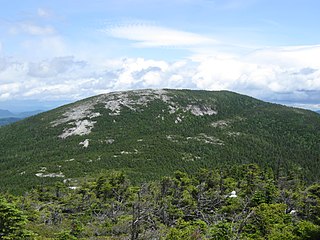
Baldpate Mountain is a mountain located in Oxford County, Maine. Baldpate has two prominent peaks; West Peak has 3,662 feet (1,116 m) of elevation, and stands 222 feet (68 m) above the col between them.

The Sourlands is a region in the central portion of the U.S. state of New Jersey that includes portions of Hunterdon County, Mercer County, and Somerset County. It is centered on Sourland Mountain and comprises parts of Lambertville, East Amwell, West Amwell, Hillsborough, Hopewell Boro, Hopewell Township, and Montgomery Township. The region is flanked by the Hopewell Fault to the south and Amwell Valley to the north that runs from Mount Airy to an area just west of Flagtown and a diabase formation running from Lambertville to Mount Airy. The Sourland also include a hilly area towards the southwest called Pleasant Valley, with a number of farms. Although much of the Sourlands is not conducive to farming, Pleasant Valley and the slopes on the surrounding ridges have a number of farms. The slopes of the ridge to the north are also home to Unionville Vineyard.

Rocky Hill Ridge, also known as the Mount Lucas-Rocky Hill Ridge, named after Lucas Voorhees, an 18th-century landowner, is a diabase trap rock ridge running west to east in the US State of New Jersey. Diabase intrusions form Baldpate Mountain and Pennington Mountain, the Mount Rose extension of the Mount Lucas-Rocky Hill ridge, and part of the Sourland Mountains. The Ridge is nine miles (14 km) long and continues across the Millstone River, just below The Georgetown Franklin Turnpike, as the Ten-Mile Run Mountain and Lawrence Brook Mountain. The western section of the ridge, which runs to the northwest to The Sourlands, is the Mount Rose section of the ridge.

Stony Brook Branch is a tributary of the Stony Brook in Mercer County, New Jersey in the United States.

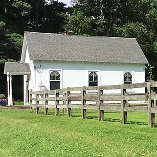
The Stoutsburg Sourland African American Museum (SSAAM) is a history museum located in the Skillman section of Montgomery Township, New Jersey, United States. The museum is located at the Mount Zion African Methodist Episcopal Church, an African Methodist Episcopal church constructed in 1899. The church was added to the National Register of Historic Places on June 7, 2021.

The Sourland Conservancy is a non-governmental, not-for-profit 501(c)(3) organization with a mission to protect, promote and preserve The Sourlands, a region encompassing Sourland Mountain in central New Jersey.
Baldpate Mountain may also refer to:


