Red Mountain (Birmingham)

Last updated

Red Mountain
Birmingham's skyline from it's highest point.jpg
Birmingham as viewed from the highest point along Red Mountain.
Highest point
Elevation 1,025 ft (312 m)
Coordinates 33°29′12″N86°48′23″W / 33.48667°N 86.80639°W / 33.48667; -86.80639 Coordinates: 33°29′12″N86°48′23″W / 33.48667°N 86.80639°W / 33.48667; -86.80639
Geography
Parent range Cahaba Ridges
Topo map USGS Birmingham South
Climbing
Easiest route Hike

Red Mountain is a long ridge running southwest-northeast and dividing Jones Valley from Shades Valley south of Birmingham, Alabama. It is part of the Ridge-and-Valley region of the Appalachian mountains. The Red Mountain Formation of hard Silurian rock strata lies exposed in several long crests, and was named "Red Mountain" because of the rust-stained rock faces and prominent seams of red hematite iron ore. The mountain was the site of the Sloss, Republic Steel, Woodward Iron and Tennessee Coal and iron mines which supplied ore to Birmingham's iron furnaces. The best displays of the mountain's geological strata occur at the Twentieth Street cut near the Vulcan statue and at the U.S. Route 31 highway cut leading into the suburb of Homewood. Most of Birmingham's television and radio stations have their transmission towers located on Red Mountain.

Contents

Red Mountain is also home to Red Mountain Park, one of the largest urban parks in the United States at 1,500 acres (6.1 km2).

Description

At Birmingham the lower 100 feet (30 m) is predominantly shaly and there is a 20-foot (6.1 m) bed of thick-layered sandstone 34 feet (10 m) above the bottom. Above this shaly part lies the Irondale ore bed, which is separated from the Big Seam of iron ore by a few feet of shale and of sandstone layers that carry large and small waterworn pebbles. Next above lies the Big seam, approximately 17 feet (5.2 m) thick, above which these is about 38 feet (12 m) of red sandstone that carries small quartz pebbles, the lower 14 feet (4.3 m) of which has yellow shale about equal in amount to sandstone. About 30 feet (9.1 m) still higher is the Pentamerus -bearing bed (Hickory Nut seam), a ferruginous sandstone full of casts of the interiors of the big brachiopod Pentamerus oblongus. There is still about 70 feet (21 m) more of sandstone, largely reddish, and shale to the top of the Red Mountain formation, making a total thickness in this part of Red Mountain of about 260 feet (79 m).
[...]The most interesting and valuable feature of the Red Mountain formation is its iron ore, which is the chief cornerstone of Alabama's industrial structure. Although ore of good quality and of workable thickness occurs elsewhere, as at Attalla, and on the Red Mountain along the west side of Murphrees Valley, the main deposit, the Big seam, lies under Shades Valley and the part of the Cahaba coal field southeast of that part of Red Mountain which extends from a point a mile or two southwest of Bessemer to Morrow Gap about 8 miles (13 km) northeast of Birmingham.
[...]The Red Mountain ores are known as a red fossil ore, because originally the iron accumulated in extensive beds of fragments of fossils, principally the hard parts of crinoids, bryozoans, and brachiopods. The iron, from solution in some form, was precipitated upon and within these beds of fossil fragments and thus the ore beds are simply a particular kind of sedimentary layers inclosed in ordinary sediments, shales, and sandstones, composing the bulk of the Red Mountain formation. As the fossil fragments were composed of calcium carbonate, which is the mineral that forms limestone, the iron ore beds at depth, where they are unweathered and where there has been no condition that permitted leaching of the lime content, carry a considerable percentage of lime, so that the ore is self-fluxing. Another type of ore is oolite ore, in which the iron oxide occurs in the form of small lenticular pellets. The precipitation of the iron that forms this ore started around some minute particle like a small grain of sand or fragment of fossil and built up a small lenticular body. The two kinds of ore are more or less mixed or one or the other may predominate in a particular layer of ore.Geology of Alabama (1926)

Neighborhood

There are many neighborhoods that are located along the 33 miles of Red Mountain, that stretches from Sparks Gap on the southwest to Trussville in the northeast. Some of these are Raimund, Muscoda, Lipscomb, Wenonah, Ishkooda, Greensprings, Irondale, Ruffner, and Trussville. Located just southeast of downtown Birmingham, on Red Mountain, is Redmont Park, which was developed in the 1920s by Robert Jemison. It was the home to Birmingham's early bankers and iron and steel industrialists. It became one of Birmingham's most prominent neighborhoods, home to the majority of the multimillion-dollar residences and estates that are located within the city proper. The prestigious Altamont School, a private school well known for its arts and science programs, is located in the neighborhood, as well as Saint Rose Academy, a Catholic parochial school run by Dominican sisters.

History

The proximity of Red Mountain's ore to nearby sources of coal and limestone was the impetus to develop and promote the Birmingham District as an industrial site. The mining of iron ore along Red Mountain began in the early 1860s as the Civil War created a demand for iron necessary to sustain the Confederate war efforts. The Union army destroyed the Oxmoor, Irondale and Tannehill furnaces in 1865 and at this point mining stopped along Red Mountain. After the Civil War the production of iron was again being renewed but this time on a commercial level. Under the leadership of such men as Debardeleben, Sloss, and Woodward the mining of iron ore along Red Mountain began again. The mountain developed a symbolic place as the source of wealth in the region and was even portrayed as a character in pageants sponsored by the steel companies in their company towns. In the Altamont and Redmont areas the abandoned mine sites served as the locations for large estates and upper-class developments which offered cool breezes and a panoramic view of the growing industrial city from above the constant layer of thick black smoke. Alex Harvey "Rick" Woodward's home is in this area along Altamont Road. His home is now owned and maintained by the University of Alabama at Birmingham and used as the residence of the University president.

As the steel furnaces modernized, labor cost rose, and geological faults in the local ore mines made the ore harder to reach, it became more economical to purchase pelletized ore from distant sources than to continue mining ore from Red Mountain. The last ore mine on Red Mountain closed in 1962 and was operated by US Steel. The last ore mine in the Birmingham district closed in 1972. It was the Pyne Mine off Highway 150 near Bessemer and was operated by the Woodward Iron Company.

In 1938, the giant cast-iron statue of the Roman god of the forge, Vulcan, which represented Birmingham in the 1904 St. Louis World's Fair was put on display atop a sandstone tower built by the Works Progress Administration. This is the world's largest cast-iron statue.

Red Mountain serves as a natural promontory for Birmingham's radio and television broadcast stations, and a setting for noteworthy private restaurant "The Club."

Red Mountain Expressway Cut

a portion of the Red Mountain Cut Red Mountain Expressway Cut.jpg
a portion of the Red Mountain Cut

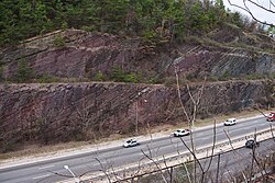
In 1970, the "Red Mountain Expressway" was completed after many years of work cutting through Red Mountain. This highway linked Birmingham with its southern suburbs and spurred suburban growth towards the south of Birmingham. The resultant cut exposed geological strata spanning millions of years, including the red ore seam that spurred Birmingham's development. A new species of Lower Silurian (middle Llandovery) phacopsid trilobite, Acaste birminghamensis, was first collected from exposures on Red Mountain [1]

Red Mountain Museum

A science museum, the Red Mountain Museum, was opened on the slope adjacent to the cut in 1971. Interpretive signage was installed along one of the terraces of the cut and guardrails and fencing installed to allow museum visitors to inspect the exposed rock close-up. From the late 1970s until 1994, the Red Mountain Museum was quite active in paleontological research, collecting fossil vertebrates and invertebrates from hundreds of localities throughout the state. The staff collected and cataloged tens of thousands of fossils, including many Cretaceous mosasaurs, Pleistocene ground sloths, and primitive Eocene archaeocete whales. Paleontologists, zoologists, geologists and archeologists once employed at the Red Mountain Museum, either as paid staff or as volunteers, include its first curator Whitman Cross, Gorden L. Bell, Jr., James P. Lamb, Winston C. Lancaster, Caitlín R. Kiernan, Susan Henson, and Amy Sheldon.

The Red Mountain Museum later formed a partnership with a nearby children's science museum, The Discovery Place, to form "Discovery 2000", which then moved away from Red Mountain to downtown Birmingham and became the McWane Science Center which opened on July 11, 1998. In 1987 the Red Mountain Expressway Cut was granted National Natural Landmark status by the National Park Service. Deemed unsafe because of the potential for rock slides, the interpretive trail has since been closed to the public. The extensive Red Mountain Museum collection is now stored at the McWane Science Center and once again available to scientists. As of October 2007, the former Red Mountain Museum building had been demolished, but plans for the site are unknown.

Literary allusions

The fantasy writer and paleontologist Caitlín R. Kiernan has used Red Mountain, particularly the area west of U.S. Route 31 and the Red Mountain cut, as the setting for four of her novels – Silk (1998), Threshold (2001), Low Red Moon (2003), and, to a much lesser extent, Murder of Angels (2004). The geography and geology of the mountain was integral to the plot of Threshold, and in a chapbook on the novel (Trilobite: The Writing of Threshold; Subterranean Press, 2003), Kiernan includes an afterword describing the geological history and paleontology of the Paleozoic strata of Red Mountain. Fannie Flagg's 2010 novel I Still Dream About You features Red Mountain prominently.

Related Research Articles

Shale Fine-grained, clastic sedimentary rock

Shale is a fine-grained, clastic sedimentary rock formed from mud that is a mix of flakes of clay minerals and tiny fragments of other minerals, especially quartz and calcite. Shale is characterized by its tendency to split into thin layers (laminae) less than one centimeter in thickness. This property is called fissility. Shale is the most common sedimentary rock.

Geology of the Grand Canyon area Aspect of geology

The geology of the Grand Canyon area includes one of the most complete and studied sequences of rock on Earth. The nearly 40 major sedimentary rock layers exposed in the Grand Canyon and in the Grand Canyon National Park area range in age from about 200 million to nearly 2 billion years old. Most were deposited in warm, shallow seas and near ancient, long-gone sea shores in western North America. Both marine and terrestrial sediments are represented, including lithified sand dunes from an extinct desert. There are at least 14 known unconformities in the geologic record found in the Grand Canyon.

Geology of the Grand Teton area

The geology of the Grand Teton area consists of some of the oldest rocks and one of the youngest mountain ranges in North America. The Teton Range, partly located in Grand Teton National Park, started to grow some 9 million years ago. An older feature, Jackson Hole, is a basin that sits aside the range.

Underground soft-rock mining Mining techniques used to extract minerals/materials from sedimentary rock

Underground soft-rock mining is a group of underground mining techniques used to extract coal, oil shale, potash, and other minerals or geological materials from sedimentary ("soft") rocks. Because deposits in sedimentary rocks are commonly layered and relatively less hard, the mining methods used differ from those used to mine deposits in igneous or metamorphic rocks. Underground mining techniques also differ greatly from those of surface mining.

Ruffner Mountain Nature Preserve

Ruffner Mountain Nature Preserve is a 1,038 acres (4.20 km2) nature preserve located in the eastern portion of Jefferson County, Alabama, in the City of Birmingham's historic South East Lake neighborhood. The preserve includes a visitor center containing native Alabama animals including raptors, snakes, turtles, and owls. The Ruffner Mountain area was home to iron ore mines and stone quarries, supplying the area's steel mills.

Laramie Formation

The Laramie Formation is a geologic formation of Late Cretaceous (Maastrichtian) age, named by Clarence King in 1876 for exposures in northeastern Colorado, in the United States. It was deposited on a coastal plain and in coastal swamps that flanked the Western Interior Seaway. It contains coal, clay and uranium deposits, as well as plant and animal fossils, including dinosaur remains.

Red Mountain Expressway Cut

The Red Mountain Expressway Cut, also known as the Red Mountain Geological Cut, is a section of Red Mountain that was blasted and removed in the 1960s to allow the Red Mountain Expressway to enter downtown Birmingham, Alabama. This highway links Birmingham with its southern suburbs of Homewood, Mountain Brook, and Vestavia Hills. It has spurred suburban growth towards the south of Birmingham. This section also provides the route for U.S. Route 31 (US 31) to the south and US 280 to the southeast.

The Woodward Iron Company was founded on December 31, 1881, by brothers William and Joseph Woodward. William was the company president and Joseph was the company secretary. The company operated iron and coal mines, quarries and furnaces; these were connected by a private industrial railroad based in Bessemer, Alabama. The company administrative office was located near Woodward Ore Mine #1, south of Paul's Hill in Bessemer.

The Pyne Mine was a vertical shaft iron ore mine operated by the Woodward Iron Company and located near the Lacey's Chapel community outside Bessemer, Alabama, in Shades Valley. It was, along with Woodward's Songo Mine, one of only two shaft mines dug in the Birmingham District, and the last ore mine to operate in the region, closing in 1971.

Pittsburgh coal seam

The Pittsburgh Coal Seam is the thickest and most extensive coal bed in the Appalachian Basin; hence, it is the most economically important coal bed in the eastern United States. The Upper Pennsylvanian Pittsburgh coal bed of the Monongahela Group is extensive and continuous, extending over 11,000 mi2 through 53 counties. It extends from Allegany County, Maryland to Belmont County, Ohio and from Allegheny County, Pennsylvania southwest to Putnam County, West Virginia.

Cleveland Ironstone Formation Geological formation in Cleveland and North Yorkshire, England

The Cleveland Ironstone Formation is a sequence of marine ironstone seams interbedded with shale and siltstone units which collectively form a part of the Lower Jurassic System of rocks underlying Cleveland in North Yorkshire. Exploitation of the ironstone seams became a major driving force behind the industrialisation of the Teesside district during the mid- to late-1800s.

Espada Formation

The Espada Formation is a sedimentary rock formation widespread in Santa Barbara County, California. Of late Jurassic to Cretaceous age, the unit consists primarily of shale with some interbedded thin layers of sandstone, conglomerate, and limestone.

Cathedral Formation

The Cathedral Formation is a stratigraphic unit in the southern Canadian Rockies of Alberta and British Columbia, on the western edge of the Western Canada Sedimentary Basin. It is a thick sequence of carbonate rocks of Middle Cambrian age. It was named for Cathedral Mountain in Yoho National Park by Charles Doolittle Walcott, the discoverer of the Burgess shale fossils.

Tonto Group Cambrian geologic unit in the Grand Canyon region, Arizona

The Tonto Group is a name for an assemblage of related sedimentary strata, collectively known by geologists as a Group, that comprises the basal sequence Paleozoic strata exposed in the sides of the Grand Canyon. As currently defined, the Tonto groups consists of the Sixtymile Formation, Tapeats Sandstone, Bright Angel Shale, Muav Limestone, and Frenchman Mountain Dolostone. Historically, it included only the Tapeats Sandstone, Bright Angel Shale, and Muav Limestone. Because these units are defined by lithology and three of them interfinger and intergrade laterally, they lack the simple layer cake geology as they are typically portrayed as having and geological mapping of them is complicated.

Benton Shale Geologic formation (shale) in Montana, Wyoming, and other states

The Benton Shale is a geologic formation name historically used in Montana, Wyoming, North Dakota, South Dakota, Colorado, Kansas, and Nebraska. In the "mile high" plains in the center of the continent, the named layers preserve marine fossils from the Late Cretaceous Period. The term Benton Limestone has also been used to refer to the chalky portions of the strata, especially the beds of the strata presently classified as Greenhorn Limestone, particularly the Fencepost limestone.

Abo Formation

The Abo Formation is a geologic formation in New Mexico. It contains fossils characteristic of the Cisuralian epoch of the Permian period.

Sliabh an Iarainn, anglicized Slieve Anierin, is a large hill in County Leitrim, Ireland. It rises to 585 metres (1,919 ft) and lies east of Lough Allen and northeast of Drumshanbo. Its present form evolved from the southwestward movement of ice age glaciers over millions of years, the morainic drift heaping thousands of drumlins in the surrounding lowlands. Historically there were many iron ore deposits and ironworks in the area. Irish mythology associates the mountain with the Tuatha Dé Danann, particularly the smith god Goibniu. Sliabh an Iarainn is an important natural heritage site with exposed marine and coastal fauna of paleontological interest

The geology of Morocco formed beginning up to two billion years ago, in the Paleoproterozoic and potentially even earlier. It was affected by the Pan-African orogeny, although the later Hercynian orogeny produced fewer changes and left the Maseta Domain, a large area of remnant Paleozoic massifs. During the Paleozoic, extensive sedimentary deposits preserved marine fossils. Throughout the Mesozoic, the rifting apart of Pangaea to form the Atlantic Ocean created basins and fault blocks, which were blanketed in terrestrial and marine sediments—particularly as a major marine transgression flooded much of the region. In the Cenozoic, a microcontinent covered in sedimentary rocks from the Triassic and Cretaceous collided with northern Morocco, forming the Rif region. Morocco has extensive phosphate and salt reserves, as well as resources such as lead, zinc, copper and silver.

The geology of South Dakota began to form more than 2.5 billion years ago in the Archean eon of the Precambrian. Igneous crystalline basement rock continued to emplace through the Proterozoic, interspersed with sediments and volcanic materials. Large limestone and shale deposits formed during the Paleozoic, during prevalent shallow marine conditions, followed by red beds during terrestrial conditions in the Triassic. The Western Interior Seaway flooded the region, creating vast shale, chalk and coal beds in the Cretaceous as the Laramide orogeny began to form the Rocky Mountains. The Black Hills were uplifted in the early Cenozoic, followed by long-running periods of erosion, sediment deposition and volcanic ash fall, forming the Badlands and storing marine and mammal fossils. Much of the state's landscape was reworked during several phases of glaciation in the Pleistocene. South Dakota has extensive mineral resources in the Black Hills and some oil and gas extraction in the Williston Basin. The Homestake Mine, active until 2002, was a major gold mine that reached up to 8000 feet underground and is now used for dark matter and neutrino research.

The geology of Utah includes rocks formed at the edge of the proto-North American continent during the Precambrian. A shallow marine sedimentary environment covered the region for much of the Paleozoic and Mesozoic, followed by dryland conditions, volcanism and the formation of the basin and range terrain in the Cenozoic. Utah is a state in the western United States.

References

  1. B. S. Norford, "Acaste birminghamensis, a new lower Silurian trilobite from Alabama", Journal of Paleontology; May 1972; v. 46; no. 3; p. 348-352

Further reading