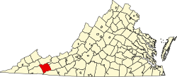
Atkins, Virginia | |
---|---|
Coordinates: 36°52′8″N81°24′36″W / 36.86889°N 81.41000°W Coordinates: 36°52′8″N81°24′36″W / 36.86889°N 81.41000°W | |
Country | United States |
State | Virginia |
County | Smyth |
Area | |
• Total | 5.4 sq mi (14.0 km2) |
• Land | 5.4 sq mi (14.0 km2) |
• Water | 0.0 sq mi (0.0 km2) |
Elevation | 2,297 ft (700 m) |
Population (2000) | |
• Total | 1,138 |
• Density | 210.6/sq mi (81.3/km2) |
Time zone | UTC−5 (Eastern (EST)) |
• Summer (DST) | UTC−4 (EDT) |
ZIP code | 24311 |
Area code | 276 |
FIPS code | 51-03512 [1] |
GNIS feature ID | 1481353 [2] |
Atkins is a census-designated place (CDP) in Smyth County, Virginia, United States. The population was 1,143 at the 2010 census.
The Old Stone Tavern was listed on the National Register of Historic Places in 1982. [3]
Atkins is located at 36°52′8″N81°24′36″W / 36.86889°N 81.41000°W (36.868967, −81.410030). [4]
According to the United States Census Bureau, the CDP has a total area of 5.4 square miles (14.0 km2), all of it land.
As of the census [1] of 2000, there were 1,138 people, 494 households, and 329 families residing in the CDP. The population density was 210.6 people per square mile (81.4/km2). There were 571 housing units at an average density of 105.7/sq mi (40.8/km2). The racial makeup of the CDP was 98.95% White, 0.09% Native American, 0.53% from other races, and 0.44% from two or more races. Hispanic or Latino of any race were 0.88% of the population.
There were 494 households, out of which 26.9% had children under the age of 18 living with them, 50.0% were married couples living together, 11.5% had a female householder with no husband present, and 33.2% were non-families. 29.1% of all households were made up of individuals, and 11.9% had someone living alone who was 65 years of age or older. The average household size was 2.30 and the average family size was 2.81.
In the CDP, the population was spread out, with 21.6% under the age of 18, 9.1% from 18 to 24, 28.4% from 25 to 44, 26.4% from 45 to 64, and 14.6% who were 65 years of age or older. The median age was 38 years. For every 100 females, there were 90.3 males. For every 100 females age 18 and over, there were 86.6 males.
The median income for a household in the CDP was $26,667, and the median income for a family was $30,625. Males had a median income of $23,274 versus $17,000 for females. The per capita income for the CDP was $17,516. About 5.6% of families and 9.6% of the population were below the poverty line, including 7.6% of those under age 18 and 6.5% of those age 65 or over.
Central Heights-Midland City is an unincorporated community and census-designated place (CDP) in Gila County, Arizona, United States. The area is home to the Pinal Cemetery which serves the community in gereneral but also contains Croatian and Serbian dedicated sections. The Gila County Health and Human Services offices are located within the region. One of the communities few nurseries is located along Golden Hill Road, a notable road in the Central Heights-Midland City area. The population was 2,534 at the 2010 census.
Fairview Shores is a census-designated place and an unincorporated area in Orange County, Florida, United States. The population was 10,239 at the 2010 census. It is part of the Orlando–Kissimmee–Sanford, Florida Metropolitan Statistical Area.
Sky Lake is a census-designated place (CDP) and an unincorporated area in Orange County, Florida, United States. The population was 6,153 at the 2010 census. It is part of the Orlando-Kissimmee, Florida Metropolitan Statistical Area.
Gandy is an unincorporated community and former census-designated place (CDP) in Pinellas County, Florida, United States. The population was 2,031 at the 2000 census. It is named after George Gandy and the Gandy Bridge which connects the area to Tampa across Old Tampa Bay.
Crooked Lake Park is a census-designated place (CDP) in Polk County, Florida, United States. The population was 1,682 at the 2000 census. It is part of the Lakeland–Winter Haven Metropolitan Statistical Area.
Hays is a census-designated place (CDP) in Wilkes County, North Carolina, United States. The population was 1,731 at the 2000 census. North Wilkes High School, one of Wilkes County's four public high schools, is located in Hays.
Millers Creek is a census-designated place (CDP) in Wilkes County, North Carolina, United States. The population was 2,112 at the 2010 census. West Wilkes High School, one of the four public high schools in Wilkes County, is located in Millers Creek.
Grandview is a census-designated place (CDP) in Hamilton County, Ohio, United States. The population was 1,466 at the 2010 census.
Pigeon Creek is a census-designated place (CDP) in Summit County, Ohio, United States. The population was 945 at the 2000 census. It is part of the Akron metropolitan statistical area.
Curtisville is a census-designated place (CDP) in Allegheny County, Pennsylvania, United States. The population was 1,064 at the 2010 census.
Rutherford is a census-designated place (CDP) in Swatara Township, Dauphin County, Pennsylvania, United States. The area is also known as Rutherford Heights. The population was 4,303 at the 2010 census, an increase over the figure of 3,859 tabulated in 2000. It is part of the Harrisburg–Carlisle Metropolitan Statistical Area.
Morrisville is a census-designated place (CDP) in Franklin Township, Greene County, Pennsylvania, United States. The population was 1,265 at the 2010 census.
Erda is a city in Tooele County, Utah, United States. The population was 4,642 at the 2010 census, a significant increase from the 2000 figure of 2,473. Erda was previously a Census Designated Place (CDP) and a township but officially received its incorporation certificate in January 2022.
Adwolfe is a census-designated place (CDP) in Smyth County, Virginia, United States. The population was 1,530 at the 2010 census.
Sugar Grove is a census-designated place (CDP) in Smyth County, Virginia, United States. The population was 758 at the 2010 census.
Max Meadows is a census-designated place (CDP) in Wythe County, Virginia, United States. The population was 562 at the 2010 census.
East Hill-Meridian is a former census-designated place (CDP) in King County, Washington. The population was 29,878 at the time of the 2010 census. The majority of the census area is now within the limits of Kent and Renton.
Plymouth is a census-designated place (CDP) in the town of Plymouth in Plymouth County, Massachusetts, United States. It is often referred to as Downtown Plymouth or Plymouth Center. The population was 7,494 at the 2010 census.
Oxford is a census-designated place (CDP) in the town of Oxford in Worcester County, Massachusetts, United States. The population was 6,103 at the 2010 census.
Madison is a census-designated place (CDP) in the town of Madison in Somerset County, Maine, United States. The population was 2,733 at the 2000 census.