
Washington County is a county located in the Commonwealth of Virginia. As of the 2020 census, the population was 53,935. Its county seat is Abingdon.

Smyth County is a county located in the U.S. state of Virginia. As of the 2020 census, the population was 29,800. Its county seat is Marion.

Marion is a town in, and the county seat of, Smyth County, Virginia, United States. It is positioned upon Interstate 81, in the Blue Ridge portion of the Southern Appalachian mountains in Southwest Virginia. The town is named for American Revolutionary War officer Francis Marion. The town limits had a population of approximately 6,000, per 2020 Census estimates. However, together with the neighborhoods, an additional 9,000 residents residing in unincorporated Smyth County have Marion mailing addresses, granting the Marion, VA ZIP code (24354) a total population of about 14,500, which is around half of the county's total population.
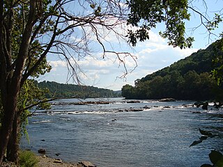
The New River Valley is a region along the New River in Southwest Virginia in the United States.

Whitetop Mountain is the second highest independent mountain in the U.S. state of Virginia, after nearby Mount Rogers. It is also the third highest named peak in Virginia, after Mount Rogers and its subsidiary peak, Pine Mountain. It is located at the juncture of Grayson, Smyth, and Washington Counties, and is also within the Mount Rogers National Recreation Area of the Jefferson National Forest. Whitetop was the location of the White Top Folk Festival from 1932 to 1939, with the exception of 1937. Like nearby Mount Rogers, it represents an ecological "island" of flora and fauna commonly found much farther north than Virginia, such as old growth red spruce and other northern softwoods.
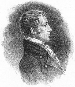
Alexander Smyth was an American lawyer, soldier, and politician from Virginia. Smyth served in the Virginia Senate, Virginia House of Delegates, United States House of Representatives and as a general during the War of 1812. Smyth County, Virginia, is named in his honor.

William Pat Jennings was a United States representative from Virginia.
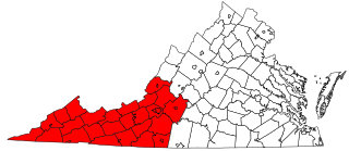
Southwest Virginia, often abbreviated as SWVA, is a mountainous region of Virginia in the westernmost part of the commonwealth. Located within the broader region of western Virginia, Southwest Virginia has been defined alternatively as all Virginia counties on the Appalachian Plateau, all Virginia counties west of the Eastern Continental Divide, or at its greatest expanse, as far east as Blacksburg and Roanoke. Another geographic categorization of the region places it as those counties within the Tennessee River watershed. Regardless of how borders are drawn, Southwest Virginia differs from the rest of the commonwealth in that its culture is more closely associated with Appalachia than the other regions of Virginia. Historically, the region has been and remains a rural area, but in the 20th century, coal mining became an important part of its economy. With the decline in the number of coal jobs and the decline of tobacco as a cash crop, Southwest Virginia is increasingly turning to tourism as a source of economic development. Collectively, Southwest Virginia's craft, music, agritourism and outdoor recreation are referred to as the region's "creative economy."

Thomas Alfred Smyth was a brigadier general in the Union Army during the American Civil War. He was the last Union general killed in the war. In March 1867, he was nominated and confirmed a brevet major general of volunteers posthumously to rank from April 7, 1865.

John Alexander Buchanan was a member of the United States House of Representatives from Virginia and a judge of the Supreme Court of Virginia.

Seven Mile Ford is a census-designated place (CDP) in Smyth County, Virginia, United States. The population as of the 2010 Census was 783. It obtained its current name as a result of being a river crossing seven miles from the Royal Oak Fort in Marion, Virginia. U.S. Hwy 11 passes through the center of the community, which is approximately 4 miles (6.4 km) from Chilhowie.
Redrock Mountain Natural Area Preserve is a 640-acre (260 ha) Natural Area Preserve located in Smyth County, Virginia. The preserve is named for the 4,413-foot (1,345 m) Redrock Mountain, which itself is named for its red siltstone cliffs. It supports a number of rare natural features, and two natural community types, including examples of "mountain/piedmont basic woodlands" upon the mountain's slopes, and "rich cove/slope forests" in the preserve's lowlands. Five rare plant species are found on the property, including spring blue-eyed Mary, fringed scorpion-weed, and Carey saxifrage.

This is a list of the National Register of Historic Places listings in Smyth County, Virginia.

The 2000 United States presidential election in Virginia took place on November 7, 2000, and was part of the 2000 United States presidential election. Voters chose 13 representatives, or electors to the Electoral College, who voted for president and vice president.

Benjamin Franklin Buchanan was an American lawyer and politician who served as the 21st Lieutenant Governor of Virginia from 1918 to 1922.
The 1996 United States presidential election in Virginia took place on November 5, 1996, as part of the 1996 United States presidential election. Voters chose 13 representatives, or electors to the Electoral College, who voted for president and vice president.
Groseclose is a populated place and unincorporated community in Smyth County, Virginia, United States.
Henry C. Groseclose was born on May 17, 1892. He lived in Ceres, Virginia for most of his life. Groseclose completed his junior college degree from Washington and Lee University in 1917. In his later years, he also received his bachelor’s degree, as well as his master’s degree, in agricultural education from Virginia Tech. While Groseclose was an agriculture teacher at the Virginia Polytechnic Institute, he, along with three other agriculture teachers, Walter Newman, Edmund Magill and Harry Sanders, decided to establish a club for the farm boys in the school. The organization was formed in 1925. Groseclose named the organization the Future Farmers of Virginia, or FFV for short.

Mountain Empire Airport is a public use airport in Smyth County, Virginia, United States. It located nine nautical miles northeast of the central business district of Marion and 13 nautical miles west of Wytheville. The airport is situated between Interstate 81 and U.S. Route 11, near Groseclose. It is owned by Smyth Wythe Airport Commission.


