Old Rag, Virginia

Last updated

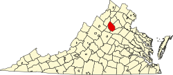
Old Rag (sometimes written Oldrag) [1] was an unincorporated community located in Madison County, Virginia, on Old Rag Mountain. Originally known as Weakley Valley, Old Rag was inhabited by white people in the 1770s. By 1900, Old Rag had a post office, [2] a school, two churches and two stores, [3] [4] and a cemetery. [5]

In 1936 the Old Rag post office, which was the last remaining post office in Shenandoah National Park, closed permanently. [6] Residents of Old Rag and several other communities were resettled to Ida Valley near the Madison Courthouse. [7] [3]

Related Research Articles

<span class="mw-page-title-main">Harpers Ferry, West Virginia</span> Town in West Virginia, United States

Harpers Ferry is a historic town in Jefferson County, West Virginia, United States, in the lower Shenandoah Valley. The population was 285 at the 2020 census. Situated at the confluence of the Potomac and Shenandoah rivers, where the U.S. states of Maryland, Virginia, and West Virginia meet, it is the easternmost town in West Virginia.

<span class="mw-page-title-main">Shenandoah County, Virginia</span> County in Virginia, United States

Shenandoah County is a county located in the Commonwealth of Virginia. As of the 2020 United States Census, the population was 44,186. Its county seat is Woodstock. It is part of the Shenandoah Valley region of Virginia.

<span class="mw-page-title-main">Rockingham County, Virginia</span> County in Virginia, United States

Rockingham County is a county located in the U.S. state of Virginia. As of the 2020 census, the population was 83,757. Its county seat is the independent city of Harrisonburg.

<span class="mw-page-title-main">Page County, Virginia</span> County in Virginia, United States

Page County is located in the Commonwealth of Virginia. As of the 2020 census, the population was 23,709. Its county seat is Luray. Page County was formed in 1831 from Shenandoah and Rockingham counties and was named for John Page, Governor of Virginia from 1802 to 1805.

<span class="mw-page-title-main">Shenandoah, Virginia</span> Town in Virginia, United States

Shenandoah is a town in Page County, Virginia, United States. The population was 2,373 at the 2010 census.

<span class="mw-page-title-main">Elkton, Virginia</span> Town in Virginia, United States

Elkton is an incorporated town in Rockingham County, Virginia, United States. It is included in the Harrisonburg Metropolitan Statistical Area. The population was 2,762 at the 2010 census. Elkton was named for the Elk Run stream.

<span class="mw-page-title-main">Strasburg, Virginia</span> Town in Virginia, United States

Strasburg is a town in Shenandoah County, Virginia, United States, which was founded in 1761 by Peter Stover. It is the largest town by population in the county and is known for its grassroots art culture, pottery, antiques, and American Civil War history. The population was 6,398 at the 2010 census.

<span class="mw-page-title-main">Shenandoah Valley</span> Region of Virginia and West Virginia

The Shenandoah Valley is a geographic valley and cultural region of western Virginia and the Eastern Panhandle of West Virginia in the United States. The valley is bounded to the east by the Blue Ridge Mountains, to the west by the eastern front of the Ridge-and-Valley Appalachians, to the north by the Potomac River and to the south by the James River. The cultural region covers a larger area that includes all of the valley plus the Virginia highlands to the west, and the Roanoke Valley to the south. It is physiographically located within the Ridge and Valley province and is a portion of the Great Appalachian Valley.

<span class="mw-page-title-main">Old Rag Mountain</span>

Old Rag Mountain is a 3,284 feet (1,001 m) mountain near Sperryville in Madison County, Virginia. A part of the Blue Ridge Mountains, the peak is located within Shenandoah National Park and is the most popular hiking destination within the park.

<span class="mw-page-title-main">Thornton Gap</span>

Thornton Gap is a wind gap located in the Blue Ridge Mountains in Virginia separating the Shenandoah Valley from the Piedmont region of the state.

<span class="mw-page-title-main">Big Meadows</span> United States historic place

Big Meadows is a recreational area of the Shenandoah National Park in Madison County and Page County, in the US state of Virginia. The meadow is located on the Skyline Drive at Milepost 51 and contains the park's Harry F. Byrd Visitor Center, a lodge, camp store, and camping area. Several hiking trails can be accessed from Big Meadows, including the Mill Prong Trail which leads to Rapidan Camp on the Rapidan River, the fishing retreat of President Herbert Hoover from 1929–1933, which is now restored to its 1930s configuration.

<span class="mw-page-title-main">Syria, Virginia</span> Settlement in Virginia, United States of America

Syria is an unincorporated village in Madison County, Virginia, United States. It lies along the Old Blue Ridge Turnpike, adjoining the southeast border of the Shenandoah National Park. Its ZIP Code is 22743.

<span class="mw-page-title-main">Etlan, Virginia</span> Unincorporated community in Virginia, United States

Etlan is an unincorporated community in Madison County, Virginia, United States. It is located near Old Rag Mountain.

<span class="mw-page-title-main">Shenandoah National Park</span> 195,000 acres in Virginia (US) maintained by the National Park Service

Shenandoah National Park is an American national park that encompasses part of the Blue Ridge Mountains in the Commonwealth of Virginia. The park is long and narrow, with the Shenandoah River and its broad valley to the west, and the rolling hills of the Virginia Piedmont to the east. Skyline Drive is the main park road, generally traversing along the ridgeline of the mountains. Almost 40% of the park's land—79,579 acres —has been designated as wilderness areas and is protected as part of the National Wilderness Preservation System. The highest peak is Hawksbill Mountain at 4,051 feet (1,235 m).

<span class="mw-page-title-main">Hughes River (Virginia)</span> River in the United States

The Hughes River is a 14.0-mile-long (22.5 km) river in Madison, Rappahannock, and Culpeper counties in the U.S. state of Virginia. The river rises on the east slope of Stony Man mountain in Shenandoah National Park and flows southeast past the village of Nethers to join the Hazel River west of Boston, Virginia. Via the Hazel River and the Rappahannock River, the Hughes River is part of the Chesapeake Bay watershed.

<span class="mw-page-title-main">Stony Man Mountain</span>

Stony Man Mountain, also known as Stony Man, is a mountain in Shenandoah National Park, Virginia and is the most northerly 4,000 foot peak in the Blue Ridge Mountains. Its maximum elevation is 4,011 feet or 1,223 meters above sea level with a clean prominence of 651 feet. The mountain is co-located in Madison and Page counties and is easily accessed from Skyline Drive by hiking trails. Along with Hawksbill Mountain, it is only one of two peaks in the park higher than 4,000 feet. The shortest route to the summit is from the Skyland Resort and gains less than 400 vertical feet in about 1 kilometer. A longer, more challenging, route is from the Skyline Drive trail head at about milepost 39 of the Skyline Drive and gains almost 800 feet. The peak sits just southeast of the Appalachian Trail (AT) but the summit is accessible from the AT by previously mentioned spur trails. On the upper slopes of Stony Man one can see a few red spruce and balsam fir trees which typically grow in more northerly latitudes. The mountain is composed of ancient basalt which was metamorphosed into Greenstone through heat and pressure.

Nineveh is an unincorporated community in Warren County, Virginia, on the main road between Winchester, Virginia, and Front Royal, Virginia. Prior to the creation of Warren County in 1836, Nineveh was in Frederick County, Virginia. A post office at Nineveh operated from the early 1800s until closing in 1954.

<span class="mw-page-title-main">Beldore Hollow, Virginia</span>

Beldore Hollow, Virginia is an extinct unincorporated community in Rockingham County, Virginia.

<span class="mw-page-title-main">Beahm, Virginia</span>

Beahm, Virginia is an extinct unincorporated community in Page County, Virginia.

References

  1. "He surveys the Old Rag Racecourse". Richmond Times-Dispatch. June 11, 1952. p. 18 via newspapers.com.
  2. "Postmaster at Old Rag, Shenandoah National Park, Virginia". Library of Congress, Washington, D.C. 20540 USA.
  3. 1 2 "Mountain Settlements (U.S. National Park Service)". www.nps.gov.
  4. "Oldrag, Va Minister explains conditions prevailing in highlands". Evening Star. September 1, 1929. p. 2 via newspapers.com.
  5. Horning, Audrey J. (January 2000). "Shenandoah's Secret History". Archaeology. 53 (1): 49. JSTOR   41779445 . Retrieved September 26, 2023.
  6. "Old Rag, Virginia. Post office closed". Evening Star. January 23, 1936. p. 14.
  7. "Byrd leads trot to top of old rag". Evening Star. October 24, 1960. p. 25.

38°33′25″N78°19′59″W / 38.55694°N 78.33306°W / 38.55694; -78.33306