Fishers Gap

Last updated
Fishers Gap
2016-10-25 10 38 42 View northwest from the Fishers Gap Overlook along Shenandoah National Park's Skyline Drive on the border of Page County, Virginia and Madison County, Virginia.jpg
View northwest from Fishers Gap Overlook
Elevation 3,064 ft (934 m) [1]
Location Madison / Page counties, Virginia, United States
Range Blue Ridge Mountains
Coordinates 38°32′00″N078°25′15″W / 38.53333°N 78.42083°W / 38.53333; -78.42083 [1]

Fishers Gap is a wind gap of the Blue Ridge Mountains located on the border of Madison County and Page County in Virginia in the Shenandoah National Park. Both Skyline Drive and the Appalachian Trail pass across the gap.

Contents

Geography

The gap is approximately 2,000 feet (610 m) above the surrounding countryside. The gap is nearly 1,000 feet (300 m) below Hawksbill Mountain, the tallest in the park, to the north and 300 feet (91 m) below Big Meadows and Stony Man Mountain to the south. The Rose River flows down the hollow on the gap's east face and Little Hawksbill creek does the same down its west face.

History

Fishers Gap is named for a Stephen Fisher who received a Northern Neck Land Grant for 216 acres at the gap on 4 August 1778. His grant reads: "....do give, grant and confirm unto Stephen Fisher of Culpeper County a certain Tract of Waste & ungranted land near Milam's Pass on the Blue Ridge in Culpeper and Shenandoah Counties bounded as by Survey thereof made by Richard Young." [2] Deeds recording subsequent sales of this 216 acres can be traced to Isaac N. Long's sale to the Virginia State Commission on Conservation on 8 July 1931. [3] The National Park Service then acquired the land for the Shenandoah National Park which labeled it: Madison County, Tract I. N. Long 141. [4] The 1932 U. S. Geological Survey for the park shows that Madison County Tract 141 is exactly at their labeled Fisher's Gap.

The reference to "Milam's Pass" in Fisher's original Grant is also found in Fisher's 1770 land survey as well as in all later deeds including Isaac Long's 1894 purchase deed: "....to wit: The tract of 216 acres more or less of land lying in the counties of Madison & Page near what is known as Milam's pass or Milam's gap on the Blue Ridge Mountains being the same land adjoining what is known as the Meadows Tract...." [5] The phrase is again found in Capt. Thomas Bohannon's 1805 land Grant: "....nigh a path called Milan's pass, on the North side of Double Top {Mountain}...." [6] These references are to an early settler on Double Top Mountain named Thomas Milam who lived just east of Bohannon's land from the 1740s to 1760 and who most probably first discovered this path or pass across the Blue Ridge Mountains to the Shenandoah Valley which for so long bore his name. [7]

Fisher's Gap doesn't appear on any map of the area until after the Gordonsville New Market Turnpike was completed in the Spring of 1853. It was constructed by the Blue Ridge Turnpike Company which was incorporated in 1848. Jedediah Hotchkiss, topographic engineer to General Thomas J. (Stonewall) Jackson, described the turnpike and his ride across Fisher's Gap in a letter to his wife in early November 1862: ".....Monday was a fine day, and I had a nice ride across the Blue Ridge, by the crookedest road I have ever seen -- 19 miles across -- but the road is a fine one -- I stopped for the night at the foot of the Mountain. Tuesday I came on to New Market....” [8] Two weeks later, during the American Civil War, Confederate General Thomas (Stonewall) Jackson led most of his army across the Gordonsville New Market Turnpike en route to Fredericksburg, where he played a significant role in the Battle of Fredericksburg a month later.

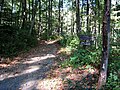
The sad end of the Gordonsville Newmarket Turnpike was recounted in the Blue Ridge Turnpike Company records of June, 1867: "....the road was used by both armies....whole organization was broken down and the {toll} Gates discontinued...." And on 5 June 1867: “....owing to the late war the Blue Ridge Turnpike Company has been disorganized...." [9] Within the Shenandoah National Park, the 105 mile long Skyline Drive was constructed between 1933 and 1939. Just north of the Big Meadows rest center - near mile marker 50 - there is the Fisher's Gap Overlook (3140 Feet Altitude). The remnants of the Gordonsville New Market Turnpike survive today as the Rose River and Redgate fire roads within the park.

Related Research Articles

<span class="mw-page-title-main">Rappahannock County, Virginia</span> County in Virginia, United States

Rappahannock County is a county located in the northern Piedmont region of the Commonwealth of Virginia, US, adjacent to Shenandoah National Park. As of the 2020 Census, the population was 7,348. Its county seat is Washington. The name "Rappahannock" comes from the Algonquian word lappihanne, meaning "river of quick, rising water" or "where the tide ebbs and flows." The county is included in the Washington-Arlington-Alexandria, DC-VA-MD-WV Metropolitan Statistical Area.

<span class="mw-page-title-main">Washington, Virginia</span> Town in Virginia

The town of Washington, Virginia, is a historic village located in the eastern foothills of the Blue Ridge Mountains near Shenandoah National Park. The entire town is listed on the National Register of Historic Places as a historic district, Washington Historic District. It is the county seat of Rappahannock County, Virginia.

<span class="mw-page-title-main">Gordonsville, Virginia</span> Town in Virginia, United States

Gordonsville is a town in Orange County in the Commonwealth of Virginia in the United States. Located about 19 miles northeast of Charlottesville and 65 miles northwest of Richmond, the population was 1,496 at the 2010 census.

<span class="mw-page-title-main">U.S. Route 522</span> Highway in the United States

U.S. Route 522 is a spur route of US 22 in the states of Virginia, West Virginia, Maryland, and Pennsylvania. The U.S. Highway travels in a north-south direction, and runs 308.59 miles (496.63 km) from US 60 near Powhatan, Virginia, to its northern terminus at US 11 and US 15 near Selinsgrove, Pennsylvania. US 522 serves many small cities and towns in the Piedmont, Blue Ridge Mountains, and northern Shenandoah Valley of Virginia. The highway serves the Virginia communities of Goochland, Mineral, Culpeper, the town of Washington, and Front Royal and the independent city of Winchester. US 522 then follows the Ridge-and-Valley Appalachians north and then east through the Eastern Panhandle of West Virginia, a 2-mile-wide (3.2 km) stretch of Western Maryland, and South Central Pennsylvania to its terminus in the Susquehanna Valley. The highway serves Berkeley Springs, West Virginia; Hancock, Maryland; and the Pennsylvania communities of McConnellsburg, Mount Union, Lewistown, and Middleburg.

<span class="mw-page-title-main">Battle of Cedar Mountain</span> 1862 battle of the American Civil War

The Battle of Cedar Mountain, also known as Slaughter's Mountain or Cedar Run, took place on August 9, 1862, in Culpeper County, Virginia, as part of the American Civil War. Union forces under Maj. Gen. Nathaniel P. Banks attacked Confederate forces under Maj. Gen. Thomas J. "Stonewall" Jackson near Cedar Mountain as the Confederates marched on Culpeper Court House to forestall a Union advance into central Virginia. After nearly being driven from the field in the early part of the battle, a Confederate counterattack broke the Union lines resulting in a Confederate victory. The battle was the first combat of the Northern Virginia campaign.

<span class="mw-page-title-main">Skyline Drive</span> National Scenic Byway in Shenandoah National Park, Virginia, USA

Skyline Drive is a 105-mile (169 km) National Parkway that runs the entire length of the National Park Service's Shenandoah National Park in the Blue Ridge Mountains of Virginia, generally along the ridge of the mountains. The drive's northern terminus is at an intersection with U.S. Route 340 (US 340) near Front Royal, and the southern terminus is at an interchange with US 250 near Interstate 64 (I-64) in Rockfish Gap, where the road continues south as the Blue Ridge Parkway. The road has intermediate interchanges with US 211 in Thornton Gap and US 33 in Swift Run Gap. Skyline Drive is part of Virginia State Route 48, which also includes the Virginia portion of the Blue Ridge Parkway, but this designation is not signed.

<span class="mw-page-title-main">Amissville, Virginia</span> Unincorporated community in Virginia, United States

Amissville is an unincorporated community in Rappahannock County in the U.S. state of Virginia. It is located on U.S. Route 211 about halfway between Warrenton and the small town of Washington, Virginia.

Swift Run Gap is a wind gap in the Blue Ridge Mountains located in the U.S. state of Virginia.

<span class="mw-page-title-main">Thornton Gap</span>

Thornton Gap is a wind gap located in the Blue Ridge Mountains in Virginia separating the Shenandoah Valley from the Piedmont region of the state.

<span class="mw-page-title-main">Ashby Gap</span>

Ashby Gap, more commonly known as Ashby's Gap is a wind gap in the Blue Ridge Mountains on the border of Clarke County, Loudoun County and Fauquier County in Virginia. The gap is traversed by U.S. Route 50. The Appalachian trail also passes across the gap.

<span class="mw-page-title-main">Sperryville, Virginia</span> Census-designated place in Virginia, United States

Sperryville is a census-designated place (CDP) located in the western section of Rappahannock County, Virginia, United States, near Shenandoah National Park. It consists of a village with two main streets along the two branches of the Thornton River, together with surrounding pasture- and farmland. The population as of the 2010 Census was 342.

<span class="mw-page-title-main">U.S. Route 50 in Virginia</span>

U.S. Route 50 is a transcontinental highway which stretches from Ocean City, Maryland to West Sacramento, California. In the U.S. state of Virginia, US 50 extends 86 miles (138 km) from the border with Washington, D.C. at a Potomac River crossing at Rosslyn in Arlington County to the West Virginia state line near Gore in Frederick County.

<span class="mw-page-title-main">U.S. Route 33 in Virginia</span> Section of interstate highway in Virginia

U.S. Route 33 is a part of the U.S. Highway System that runs from Elkhart, Indiana to Richmond, Virginia. In Virginia, the U.S. Highway runs 135.60 miles (218.23 km) from the West Virginia state line near Rawley Springs east to its eastern terminus at SR 33 in Richmond. US 33 is the primary east–west highway of Rockingham County, which lies in the Shenandoah Valley. The highway connects the independent city of Harrisonburg, the town of Elkton, and an entrance to Shenandoah National Park. East of the Blue Ridge Mountains, US 33 connects the Piedmont communities of Stanardsville, Gordonsville, and Louisa. The U.S. Highway is a major suburban and urban route in the Richmond metropolitan area. Within Richmond, US 33 runs concurrently with US 250. SR 33 continues from US 33's eastern terminus as a state-numbered extension of the U.S. Highway that connects Richmond with Virginia's Middle Peninsula.

<span class="mw-page-title-main">Virginia State Route 231</span>

State Route 231 is a primary state highway in the U.S. state of Virginia. The state highway runs 49.82 miles (80.18 km) from SR 22 in Cismont north to U.S. Route 522 near Sperryville. SR 231 forms part of the connection between Charlottesville and Gordonsville, where the highway meets US 15 and US 33. The state highway also serves as the main north–south highway of Madison County, connecting the county seat of Madison, where the highway intersects US 29, with Gordonsville to the south and passing through the foothills of the Blue Ridge Mountains to the north.

<span class="mw-page-title-main">U.S. Route 250 in Virginia</span>

U.S. Route 250 is a part of the U.S. Highway System that runs from Sandusky, Ohio to Richmond, Virginia. In Virginia, the highway runs 166.74 miles (268.34 km) from the West Virginia state line near Hightown east to its eastern terminus at US 360 in Richmond. US 250 is the main east–west highway of Highland County, which is known as Virginia's Little Switzerland; the highway follows the path of the 19th century Staunton and Parkersburg Turnpike. From Staunton east to Richmond, the highway serves as the local complement to Interstate 64 (I-64), roughly following the 18th century Three Notch'd Road through Waynesboro and Charlottesville on its way through the Shenandoah Valley, its crossing of the Blue Ridge Mountains at Rockfish Gap, and the Piedmont. In the Richmond metropolitan area, US 250 is known as Broad Street, a major thoroughfare through the city's West End and downtown areas.

The Snicker's Gap Turnpike was a turnpike road in the northern part of the U.S. state of Virginia. Part of it is now maintained as State Route 7, a primary state highway, but the road between Aldie and Bluemont in Loudoun County, via Mountville, Philomont, and Airmont, is a rural Virginia Byway known as Snickersville Turnpike, and includes the about 180-year-old Hibbs Bridge over Beaverdam Creek. This turnpike replaced, in part, the first toll road in the United States, which consisted of two roads from Alexandria northwest into the Shenandoah Valley.

<span class="mw-page-title-main">Snickers Gap</span>

Snickers Gap, originally William's Gap, is a wind gap in the Blue Ridge Mountain on the border of Loudoun County and Clarke County in Virginia. The gap is traversed by Virginia State Route 7. The Appalachian Trail also passes across the gap. Bear's Den and Raven Rocks are adjacent to the gap.

<span class="mw-page-title-main">Fairfax Line</span> Surveyors line

The Fairfax Line was a surveyor's line run in 1746 to establish the limits of the "Northern Neck land grant" in colonial Virginia.

<span class="mw-page-title-main">Shenandoah National Park</span> 195,000 acres in Virginia (US) maintained by the National Park Service

Shenandoah National Park is an American national park that encompasses part of the Blue Ridge Mountains in the Commonwealth of Virginia. The park is long and narrow, with the Shenandoah River and its broad valley to the west, and the rolling hills of the Virginia Piedmont to the east. Skyline Drive is the main park road, generally traversing along the ridgeline of the mountains. Almost 40% of the park's land—79,579 acres —has been designated as wilderness areas and is protected as part of the National Wilderness Preservation System. The highest peak is Hawksbill Mountain at 4,051 feet (1,235 m).

<span class="mw-page-title-main">McPherson Ridge</span>

McPherson Ridge is a landform used for military engagements during the 1863 Battle of Gettysburg, when the I Corps of the Union Army had a headquarters on the ridge and was defeated by the Confederate division of Major General Henry Heth. The ridge has terrain above ~530 ft (160 m) and is almost entirely a federally protected area except for township portions at the southern end and along Pennsylvania Route 116, including a PennDOT facility. The northern end is a slight topographic saddle point on the west edge of Oak Ridge, and summit areas above 560 ft (170 m) include 4 on/near the Lincoln Highway, a broader summit south of the Fairfield Road, and the larger plateau at the northern saddle.

References

  1. 1 2 "Fishers Gap". Geographic Names Information System . United States Geological Survey, United States Department of the Interior.
  2. Commonwealth of Virginia, Northern Neck Grants, Culpeper County, Book Q (4 August 1778), 319.
  3. Commonwealth of Virginia, Madison County Deed Book 50 (8 July 1931), 398.
  4. Reed L. Engle and Caroline Janney, A Database of Shenandoah National Park Land Records (Shenandoah National Park, National Park Service, U.S. Dept. of the Interior, 1997), 68.
  5. Commonwealth of Virginia, Madison County Deed Book 32 (22 Feb 1894), 286 - 287.
  6. Commonwealth of Virginia, Northern Neck Grants, Madison County, Book A2 (19 Aug 1805), 122 - 123.
  7. Commonwealth of Virginia, Culpeper County, Deed Book C (17 Aug 1760), 373 - 376.
  8. Jedediah Hotchkiss to Sara A. Hotchkiss, 12 Nov 1862 (Jedediah Hotchkiss Collection, Reel 4, Manuscripts Division, Library of Congress, Washington, D.C.)
  9. Library of Virginia, Board of Public Records, Blue Ridge Turnpike Company, Items # 215 and # 549