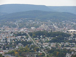
Altoona is a city in Blair County, Pennsylvania, United States. The population was 43,963 at the time of the 2020 census, making it the 18th-most populous city in Pennsylvania. It is the principal city of the Altoona metropolitan area, which includes all of Blair County and was recorded as having a population of 122,822 at the 2020 census.
Logan Township is a township in Blair County, Pennsylvania, United States. It is part of the Altoona, PA Metropolitan Statistical Area. It is the most populous township in Blair County, with a population of 12,413 at the 2020 census. Logan Township is home to Horseshoe Curve, a National Historic Landmark.
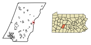
Gallitzin is a borough in Cambria County, Pennsylvania, United States. It is bordered by Gallitzin Township and Tunnelhill, all of which sit astride the Eastern continental divide. Tunnel Hill and Gallitzin both are pierced by railroad tunnels shortening the necessary ascent for rails crossing the Allegheny Front onto the Allegheny Plateau which encompasses the towns' terrains. Topping the gaps of the Allegheny, the area is one of only five major breaks in the Appalachians allowing east–west transportation corridors before the advent of 20th century technologies.

The Great Appalachian Valley, also called The Great Valley or Great Valley Region, is one of the major landform features of eastern North America. It is a gigantic trough, including a chain of valley lowlands, and the central feature of the Appalachian Mountains system. The trough stretches about 1,200 miles (1,900 km) from Quebec in the north to Alabama in the south and has been an important north–south route of travel since prehistoric times.

The Kittanning Path was a major east-west Native American trail that crossed the Allegheny Mountains barrier ridge connecting the Susquehanna River valleys in the center of Pennsylvania to the highlands of the Appalachian Plateau and thence to the western lands beyond drained by the Ohio River. Kittanning Village was the first major Delaware (Lenape) Indian settlement along the descent from the Allegheny Plateau.

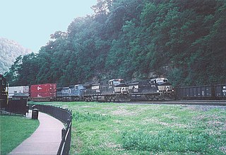
The Horseshoe Curve is a three-track railroad curve on Norfolk Southern Railway's Pittsburgh Line in Blair County, Pennsylvania. The curve is roughly 2,375 feet (700 m) long and 1,300 feet (400 m) in diameter. Completed in 1854 by the Pennsylvania Railroad as a way to reduce the westbound grade to the summit of the Allegheny Mountains, it replaced the time-consuming Allegheny Portage Railroad, which was the only other route across the mountains for large vehicles. The curve was later owned and used by three Pennsylvania Railroad successors: Penn Central, Conrail, and Norfolk Southern.

The Allegheny Portage Railroad was the first railroad constructed through the Allegheny Mountains in central Pennsylvania. It operated from 1834 to 1854 as the first transportation infrastructure through the gaps of the Allegheny that connected the midwest to the eastern seaboard across the barrier range of the Allegheny Front. Approximately 36 miles (58 km) long overall, both ends connected to the Pennsylvania Canal, and the system was primarily used as a portage railway, hauling river boats and barges over the divide between the Ohio and the Susquehanna Rivers. Today, the remains of the railroad are preserved within the Allegheny Portage Railroad National Historic Site operated by the National Park Service.
The Allegheny Front is the major southeast- or east-facing escarpment in the Allegheny Mountains in southern Pennsylvania, western Maryland, eastern West Virginia, and western Virginia. The Allegheny Front forms the boundary between the Ridge-and-Valley Appalachians to its east and the Appalachian Plateau to its west. The Front is closely associated with the Appalachian Mountains' Eastern Continental Divide, which in this area divides the waters of the Ohio/Mississippi river system, flowing to the Gulf of Mexico, from rivers flowing into Chesapeake Bay and from there into the Atlantic Ocean.
There are many historic trails and roads in the United States which were important to the settlement and development of the United States including those used by American Indians.

A horseshoe curve is a class of climbing curve in a roadbed that reverses turn direction (inflection) twice on either side of a single tight curve that varies through an angle of about 180 degrees or more.

The Mid State Trail (MST) is a 327-mile (526 km) linear hiking trail located in the Appalachian Mountains and Allegheny Plateau of central Pennsylvania, United States. It is the longest hiking trail in Pennsylvania, and one of just three to traverse the state from one border to another. A portion of the Mid State Trail is also part of the Great Eastern Trail.

The Great Indian Warpath (GIW)—also known as the Great Indian War and Trading Path, or the Seneca Trail—was that part of the network of trails in eastern North America developed and used by Native Americans which ran through the Great Appalachian Valley. The system of footpaths extended from what is now upper New York to deep within Alabama. Various Native peoples traded and made war along the trails, including the Catawba, numerous Algonquian tribes, the Cherokee, and the Iroquois Confederacy. The British traders' name for the route was derived from combining its name among the northeastern Algonquian tribes, Mishimayagat or "Great Trail", with that of the Shawnee and Delaware, Athawominee or "Path where they go armed".

Brownsville Road is a road between Pittsburgh, at Eighteenth Street and South Avenue in Allegheny County, Pennsylvania eastwards through Mount Oliver and generally highlands situated along or near the hilltops often overlooking the Monongahela River. It has had several names over its history, and was also known at the Red Stone Road and the period it was a Plank Road managed as a toll road, the Brownsville Plank Road, or the Brownsville Turnpike, or locally, as the area grew into a city, Southern Avenue.
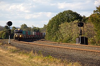
The Pittsburgh Line is the Norfolk Southern Railway's primary east–west artery in its Pittsburgh Division and Harrisburg Division across the U.S. state of Pennsylvania and is part of the Keystone Corridor, Amtrak-Norfolk Southern's combined rail corridor.
The Kittanning Run is one of the several streams draining the Allegheny Plateau, each one cutting an abrupt valley, one of the gaps of the Allegheny— one of several climbing valleys used for centuries by the Amerindian native peoples to pass East-to-West through the Allegheny Front escarpment, a barrier ridge separating the flat highlands plateau, the Appalachian Plateau—from the many barrier ridges making up the local Ridge-and-Valley Appalachians in the Central Pennsylvania heartland.
Blair Gap, one of the gaps of the Allegheny, is a water gap along the eastern face atop the Allegheny Front escarpment. Like other gaps of the Allegheny, the slopes of Blair Gap were amenable to foot travel, pack mules, and possibly wagons allowing Amerindians, and then, after about 1778–1780 settlers, to travel west into the relatively depopulated Ohio Country decades before the railroads were born and tied the country together with steel.
The gaps of the Allegheny, meaning gaps in the Allegheny Ridge in west-central Pennsylvania, is a series of escarpment eroding water gaps along the saddle between two higher barrier ridge-lines in the eastern face atop the Allegheny Ridge or Allegheny Front escarpment. The front extends south through Western Maryland and forms much of the border between Virginia and West Virginia, in part explaining the difference in cultures between those two post-Civil War states. While not totally impenetrable to daring and energetic travelers on foot, passing the front outside of the water gaps with even sure footed mules was nearly impossible without navigating terrain where climbing was necessary on slopes even burros would find extremely difficult.
Conestoga Road, also called "Conestoga Pike" or "Allegheny Path", is a historic road dating from at least 1684 in what is now the U.S. state of Pennsylvania. It starts as Allegheny Avenue in Philadelphia to the west through Morgantown, Harrisburg and west towards the Allegheny Valley. Originally the road was a walking path that was 12-18 inches in width. During the era of horse drawn Conestoga wagons, the road was widened. During most of its existence as a turnpike, it served as the alternate route to the Lancaster Pike and Ridge Road. The route gained notoriety as the shortest route from Philadelphia to Harrisburg.
Carson Valley is an unincorporated community and census-designated place (CDP) in Blair County, Pennsylvania, United States. It was first listed as a CDP prior to the 2020 census.


