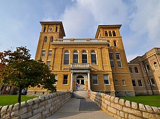
Wise County is a county located in the U.S. state of Virginia. The county was formed in 1856 from Lee, Scott, and Russell Counties and named for Henry A. Wise, who was the Governor of Virginia at the time.

The Great Appalachian Valley, also called The Great Valley or Great Valley Region, is one of the major landform features of eastern North America. It is a gigantic trough, including a chain of valley lowlands, and the central feature of the Appalachian Mountains system. The trough stretches about 1,200 miles (1,900 km) from Quebec in the north to Alabama in the south and has been an important north–south route of travel since prehistoric times.

The Transylvania Colony, also referred to as the Transylvania Purchase, was a short-lived, extra-legal colony founded in early 1775 by North Carolina land speculator Richard Henderson, who formed and controlled the Transylvania Company. Henderson and his investors had reached an agreement to purchase a vast tract of Cherokee lands west of the southern and central Appalachian Mountains through the acceptance of the Treaty of Sycamore Shoals with most leading Cherokee chieftains then controlling these lands. In exchange for the land the tribes received goods worth, according to the estimates of some scholars, about 10,000 British pounds. To further complicate matters, this frontier land was also claimed by the Virginia Colony and a southern portion by Province of North Carolina.
Trans-Appalachia is an area in the United States bounded to the east by the Appalachian Mountains and extends west roughly to the Mississippi River. It spans from the Midwest to the Upper South. The term is used most frequently when referring to the area as a frontier in the 18th and 19th century. During this period, the region gained its own identity, defined by its isolation and separation from the rest of the United States to the east. It included much of Ohio Country and at least the northern and eastern parts of the Old Southwest. It was never an organized territory or other political unit. Most of what was referred to by this name became the states of western Pennsylvania, Ohio, West Virginia, Kentucky, Tennessee and western Virginia. It is still a vague and little used place name today.

The Ridge-and-Valley Appalachians, also called the Ridge and Valley Province or the Valley and Ridge Appalachians, are a physiographic province of the larger Appalachian Highlands division. The physiographic province is divided into three sections: the Hudson Valley, the Central, and the Tennessee.
The Wilderness Road was one of two principal routes used by colonial and early national era settlers to reach Kentucky from the East. Although this road goes through the Cumberland Gap into southern Kentucky and northern Tennessee, the other is sometimes called the "Cumberland Road" because it started in Fort Cumberland in Maryland. Despite Kentucky Senator Henry Clay's advocacy of this route, early in the 19th century, the northern route was selected for the National Road, connecting near Washington, Pennsylvania into the Ohio Valley of northern Kentucky and Ohio.
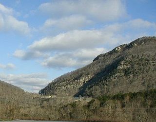
The Cumberland Gap is a pass in the eastern United States through the long ridge of the Cumberland Mountains, within the Appalachian Mountains and near the tripoint of Kentucky, Virginia, and Tennessee. At an elevation of 1,631 feet (497 m) above sea level, it is famous in American colonial history for its role as a key passageway through the lower central Appalachians.

U.S. Route 25E (US 25E) is the eastern branch of US 25 from Newport, Tennessee, where US 25 splits into US 25E and US 25W, to North Corbin, Kentucky, where the two highways rejoin. The highway, however, continues as US 25E for roughly two miles (3.2 km) until it joins Interstate 75 (I-75) in the Laurel County community of North Corbin at exit 29. The highway serves the Appalachia regions of Kentucky's Cumberland Plateau and the Ridge-and-Valley section of East Tennessee, including the urbanized areas of Corbin and Middlesboro in Kentucky and Morristown in Tennessee.

U.S. Route 421 (US 421) is a part of the U.S. Highway System that runs from Fort Fisher, North Carolina to Michigan City, Indiana. In Virginia, the U.S. Highway runs 69.23 miles (111.41 km) from the Tennessee state line between the twin cities of Bristol, Tennessee and Bristol, Virginia north and west to the Kentucky state line near St. Charles. Between its endpoints, US 421 has lengthy concurrencies with US 23 and US 58 during its course through Bristol, Weber City, Gate City, Duffield, and Pennington Gap in Southwest Virginia.

U.S. Route 23 (US 23) is a part of the United States Numbered Highway System that runs from Jacksonville, Florida, to Mackinaw City, Michigan. In Virginia, the U.S. Highway runs 60.80 miles (97.85 km) from the Tennessee state line near Weber City north to the Kentucky state line near Pound. US 23, which is known as Orby Cantrell Highway for most of its course, is a four-lane divided highway that follows Corridor B of the Appalachian Development Highway System through Southwest Virginia. The U.S. Highway serves as the main east–west highway of Scott County and the primary north–south highway of Wise County. US 23 runs concurrently with US 58 from Weber City to Duffield and with US 58 Alternate between Big Stone Gap and the independent city of Norton.

The Sycamore Shoals of the Watauga River, usually shortened to Sycamore Shoals, is a rocky stretch of river rapids along the Watauga River in Elizabethton, Tennessee. Archeological excavations have found Native Americans lived near the shoals since prehistoric times, and Cherokees gathered there. As Europeans began settling the Trans-Appalachian frontier, the shoals proved strategic militarily, as well as shaped the economies of Tennessee and Kentucky. Today, the shoals are protected as a National Historic Landmark and are maintained as part of Sycamore Shoals State Historic Park.

Clinch Mountain is a mountain ridge in the U.S. states of Tennessee and Virginia, lying in the ridge-and-valley section of the Appalachian Mountains. From its southern terminus at Kitts Point, which lies at the intersection of Knox, Union and Grainger counties near Blaine, Tennessee, it runs in a generally east-northeasterly direction to Garden Mountain near Burke's Garden, Virginia. It separates the Clinch River basin to the north and the Holston River basin to the south.
Powell Mountain is a mountain ridge of the Ridge-and-valley Appalachians of the Appalachian Mountains. It is a long and narrow ridge, running northeast to southwest, from about Norton, Virginia, to near Tazewell, Tennessee. It separates the Clinch River basin and the Powell River basin of Powell Valley. It was named for an 18th-century explorer.

A longhunter was an 18th-century explorer and hunter who made expeditions into the American frontier for as much as six months at a time.

U.S. Route 58 Alternate is an 87.40-mile-long (140.66 km) alternate route to US 58 in western Virginia. The route is a northern bypass to US 58 which stays closer to the Tennessee border and serves Gate City and Bristol.

The Great Indian Warpath (GIW)—also known as the Great Indian War and Trading Path, or the Seneca Trail—was that part of the network of trails in eastern North America developed and used by Native Americans which ran through the Great Appalachian Valley. The system of footpaths extended from what is now upper New York to deep within Alabama. Various Native peoples traded and made war along the trails, including the Catawba, numerous Algonquian tribes, the Cherokee, and the Iroquois Confederacy. The British traders' name for the route was derived from combining its name among the northeastern Algonquian tribes, Mishimayagat or "Great Trail", with that of the Shawnee and Delaware, Athawominee or "Path where they go armed".
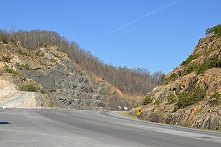
The Pound Gap of Pine Mountain is on the Virginia/Kentucky border between Jenkins, Kentucky and Pound, Virginia. It served as a passage for early settlers to cross into Kentucky from Virginia. Today, U.S. Route 23 passes through the gap.
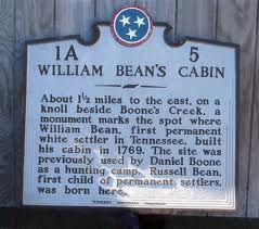
William Bean was an American pioneer, longhunter, and Commissioner of the Watauga Association. He is accepted by historians as the first permanent European American settler of Tennessee.

The Path Grant Deed is a document regarded as a first step toward the American westward migration across the Appalachian Mountains, resulting from negotiations at Sycamore Shoals in March 1775. The land acquired within the boundaries of the Path Grant allowed Daniel Boone to develop the Wilderness Road free from attack or claims by the Cherokee. The Path Grant was recorded on November 15, 1794, by the Hawkins County, Tennessee registrar in Deed Book #1, pages 147-151

The East Tennessee Crossing Byway is a 83-mile (134 km) National Scenic Byway in the U.S. state of Tennessee. Established in 2009, it is one of the newest byways in the National Scenic Byway system. The scenic byway traverses mostly along an unsigned concurrency of U.S. Route 25E/State Route 32 (US 25E/SR 32) in East Tennessee.

