River, Kentucky | |
|---|---|
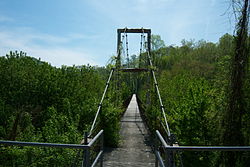 The Forrest and Maxie Preston Memorial Bridge | |
 River  River | |
| Coordinates: 37°51′39.57″N82°43′34.43″W / 37.8609917°N 82.7262306°W | |
| Country | United States |
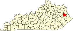
| State | Kentucky |
| County | Johnson |
| Elevation | 633 ft (193 m) |
| Time zone | UTC-5 (Eastern (EST)) |
| • Summer (DST) | UTC-5 (EDT) |
| ZIP code | 41254 |
| Area code | 606 |
| GNIS feature ID | 501977 [1] |
River is an unincorporated community in Johnson County, Kentucky, United States. The post office was first established on September 6, 1890, and its current ZIP code is 41254. Its telephone area code is 606. [2] [3] Its geographic coordinates are (37.86102 N, 82.72623 W).