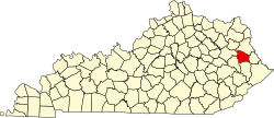
Elna, Kentucky | |
---|---|
Coordinates: 37°54′30″N82°57′42″W / 37.90833°N 82.96167°W | |
Country | United States |
State | Kentucky |
County | Johnson |
Elevation | 876 ft (267 m) |
Time zone | UTC-5 (Eastern (EST)) |
• Summer (DST) | UTC-4 (EDT) |
GNIS feature ID | 507934 |
Elna is an unincorporated community in Johnson County, Kentucky, United States. It is located at an elevation of 876 feet (267 m). [1] Elna is located in the ZIP Code Tabulation Area for ZIP code 41219. [2]
Hager Hill (also Hagerhill) is an unincorporated community in Johnson County, Kentucky, United States. Hager Hill is located approximately four miles south of Paintsville, the county seat of Johnson County.
Varney is an unincorporated community in Pike County, Kentucky, United States. Its ZIP Code is 41571; the population of the 41571 ZIP Code Tabulation Area (ZCTA) was 543 at the 2000 census.
Elizaville is a census-designated place and unincorporated community in Fleming County, Kentucky, United States. Its population was 181 as of the 2010 census. Elizaville is located at the junction of Kentucky Route 32 and Kentucky Route 170, 5 miles (8.0 km) west of Flemingsburg. Elizaville has a post office with ZIP code 41037.
Flat Gap is an unincorporated community in Johnson County, Kentucky, United States. The community was named after the "flat gap" formed at the divide between the Lower Laurel and Mudlick Creeks. Flat Gap's first post office was established on February 26, 1873, with Henry Jayne as postmaster. Its ZIP code is 41219.
Drift, Kentucky is an unincorporated community and coal town in Floyd County, Kentucky, United States. As of the census of 2000, there were 569 people living in the ZIP Code Tabulation Area (ZCTA) for Drift's ZIP code (41619).
Redbush is an unincorporated community in Johnson County, Kentucky, United States. The community's first post office opened in 1904, with William A. Williams as postmaster. Williams also named Redbush after several small pin oaks that turned red in the fall near his post office. The community's ZIP code is 41219.
Volga is an unincorporated community in Johnson County, Kentucky, United States. Its ZIP Code is 41219. Volga is located at an elevation of 718 feet.
Fuget is an unincorporated community in Johnson County, Kentucky, United States. Fuget is located at an elevation of 823 feet. It is located in the ZIP Code Tabulation Area for ZIP code 41219.
Sitka is an unincorporated community with U.S. Post Office centered on KY Route 201, in Johnson County, Kentucky, United States. It is located at an elevation of 712 feet. Sitka's ZIP code is 41255.
Winifred is an unincorporated community in Johnson County, Kentucky, United States. It is located at an elevation of 840 feet. Winifred is located in the ZIP Code Tabulation Area for ZIP code 41219, which includes the nearby community of Flat Gap.
Odds is an unincorporated community in Johnson County, Kentucky, United States. It is located at an elevation of 640 feet. Odds is located in the ZIP Code Tabulation Area for ZIP code 41265.
Nero is an unincorporated community in Johnson County, Kentucky, United States. It is located at an elevation of 628 feet. Nero is located in the ZIP Code Tabulation Area for ZIP code 41265.
Sip is an unincorporated community in Johnson County, Kentucky, United States. It is located at an elevation of 837 feet. Its ZIP code is 41219.
Hargis is an unincorporated community in Johnson County, Kentucky, United States. It is located at an elevation of 915 feet. It is located in the ZIP Code Tabulation Area (ZCTA) for ZIP code 41238.
Burnaugh, Kentucky is an unincorporated community located in Boyd County, Kentucky along U.S. Route 23. Being located between the Burgess Station, a former C&O Freight and passenger terminal and Kavanaugh, it takes its name from the combination of the two communities. It is located on both the former Mayo Trail and present-day U.S. Route 23. Burnaugh is located within the ZIP Code Tabulation Area for zip code 41129, which includes the nearby city of Catlettsburg.
Durbin, Kentucky is an unincorporated community situated along Kentucky Route 752 and Durbin Creek in southern Boyd County, Kentucky. The post office was established on March 5, 1900, with Robert Struther as postmaster, and was named for Amos Durbin, an early explorer. It is located within the ZIP Code Tabulation Area for zip code 41129, which includes the city of Catlettsburg.
Pruden is an unincorporated community located partly in Bell County, Kentucky and partly in Claiborne County, Tennessee, in the southeastern United States. It is located along Tennessee State Route 90 and Kentucky Route 74, which intersect at the state line, in the upper Clearfork Valley.
Vancleve is an unincorporated community in Breathitt County, Kentucky. Vancleve is located at the junction of Kentucky Route 15 and Kentucky Route 205 5.4 miles (8.7 km) north-northwest of Jackson. Vancleve has a post office with ZIP code 41385, which opened on November 6, 1903. Kentucky Mountain Bible College is located in Vancleve.
Lejunior is an unincorporated community in Harlan County, Kentucky, United States. The community is located along Kentucky Route 38 and the Cumberland River 4.3 miles (6.9 km) northeast of Evarts. Lejunior has a post office with ZIP code 40849.
Jetson is an unincorporated community in Butler County, Kentucky, United States.