Kerz, Kentucky | |
|---|---|
 Kerz  Kerz | |
| Coordinates: 37°55′00″N82°50′23″W / 37.91667°N 82.83972°W | |
| Country | United States |
| State | Kentucky |
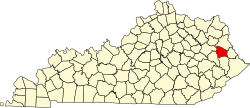
| County | Johnson |
| Elevation | 843 ft (257 m) |
| Time zone | UTC-5 (Eastern (EST)) |
| • Summer (DST) | UTC-4 (EDT) |
| ZIP codes | 41255 |
| GNIS feature ID | 508383 |
Kerz is an unincorporated community in Johnson County, Kentucky, United States. It is located at an elevation of 843 feet (257 m). [1] Its ZIP code is 41255.