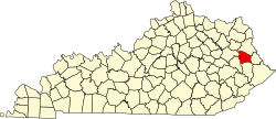
Wittensville, Kentucky | |
---|---|
Coordinates: 37°51′46″N82°47′59″W / 37.86278°N 82.79972°W | |
Country | United States |
State | Kentucky |
County | Johnson |
Elevation | 692 ft (211 m) |
Population (2000) | |
• Total | 624 |
Time zone | UTC-5 (Eastern (EST)) |
• Summer (DST) | UTC-4 (EDT) |
ZIP codes | 41274 |
GNIS feature ID | 509395 |
Wittensville is an unincorporated community in Johnson County, Kentucky, United States. It has a United States Postal Service and its ZIP code is 41274.
Wittensville has an elevation of 692 feet. [1] It was first resided in 1843.
As of the census of 2000, [2] there were 624 people, 250 households, and 192 families residing in the ZIP Code Tabulation Area (ZCTA for Wittensville's ZIP code. The racial makeup of the ZCTA was 98.6% White, 0.2% African American, and 0.5% Asian.
There were 250 households, out of which 39.6% had children under the age of 18, 51.2% were married couples living together, 8.5% had a female householder with no husband present, and 22.6% were non-families. 18.8% of all households were made up of individuals. The average household size was 2.50 and the average family size was 2.79.
The median income for a household in the ZCTA was $14,635, and the median income for a family was $18,750. Males had a median income of $25,948 and $18,274 for females. The per capita income was $7,517. 34.7% of the families in the community were below the poverty line.
Most students living in Wittensville attend: [3]
Johnson County is a county located in the U.S. state of Kentucky. As of the 2020 census, the population was 22,680. Its county seat is Paintsville. The county was formed in 1843 and named for Richard Mentor Johnson, a colonel of the War of 1812, United States Representative, Senator, and Vice President of the United States.
Martin Township is a civil township of Allegan County in the U.S. state of Michigan. The population was 2,723 at the 2020 census.
Campbell Township is a civil township of Ionia County in the U.S. state of Michigan. Its population was 2,243 at the 2000 census.
Lyon Charter Township is a charter township of Oakland County in the U.S. state of Michigan. The population was 14,545 at the 2010 census.
Highland Township is a civil township of Osceola County in the U.S. state of Michigan. The population was 1,207 at the 2000 census.
Custer Township is a civil township of Sanilac County in the U.S. state of Michigan. The population was 893 at the 2020 census.
Elk Township is a civil township of Sanilac County in the U.S. state of Michigan. The population was 1,522 at the 2020 census.
Watertown Township is a civil township of Sanilac County in the U.S. state of Michigan. The population was 1,376 at the 2000 census.
Watertown Township is a civil township of Tuscola County in the U.S. state of Michigan. The population was 2,202 at the 2010 Census.
Westway is a census-designated place (CDP) in El Paso County, Texas, United States. The population was 4,188 at the 2010 census. It is part of the El Paso Metropolitan Statistical Area. It is located east of Interstate 10, approximately 2 miles (3 km) from the New Mexico - Texas state line. The ZIP Code encompassing the CDP area is 79835.
Deepwater is an unincorporated community located within Pennsville Township, in Salem County, in the U.S. state of New Jersey. The community is located at the east end of the Delaware Memorial Bridge. Deepwater is the location of the United States Postal Service area covering ZIP code 08023. At the 2000 census, the ZCTA had a population of 345.
Lewistown is an unincorporated community and census-designated place (CDP) in central Washington Township, Logan County, Ohio, United States. As of the 2020 census, the population was 202.
Redwood Valley is a census-designated place (CDP) in Mendocino County, California, United States. It is located 9 miles (14 km) north of Ukiah, the county seat, at an elevation of 722 feet (220 m), and comprises the northern portion of the Ukiah Valley. It is about 15 miles (24 km) southeast of Willits. Potter Valley is to the east and Calpella to the south. The ZIP Code is 95470, and the community is in area code 707. The population of the CDP was 1,843 at the 2020 census.
Van Lear is an unincorporated community and coal town in Johnson County, Kentucky, United States.
Hager Hill (also Hagerhill) is an unincorporated community in Johnson County, Kentucky, United States. Hager Hill is located approximately four miles south of Paintsville, the county seat of Johnson County.
Oil Springs is an unincorporated community in Johnson County, Kentucky, United States. It lies along Route 40 west of the city of Paintsville, the county seat of Johnson County. It has a post office with the ZIP code 41238.
Tutor Key is an unincorporated community in Johnson County, Kentucky, United States about 4.5 miles northeast of Paintsville. Tutor Key was originally known as Mingo.
Staffordsville is an unincorporated community in Johnson County, Kentucky, United States. The community was originally named Frew and the first post office was established on July 14, 1882, with Millard F. Rule as postmaster but in 1893, postmistress Jessie Stafford changed the post office's name to "Staffordsville" in order to honor her family. Staffordsville's ZIP code is 41256.
Thealka is an unincorporated community in Johnson County, Kentucky, United States. It was created by the North East Coal Company in 1906.and was originally called Muddy Branch. In 1911, it was renamed "Thealka" after the steamboat known by the same name. Both the community and the steamboat were named after John C.C. Mayo's wife, Alice Jane Mayo, who was given the nickname "Alka". Thealka is in the 41240 ZIP Code Tabulation Area, which includes the nearby city of Paintsville.
Flat Gap is an unincorporated community in Johnson County, Kentucky, United States. The community was named after the "flat gap" formed at the divide between the Lower Laurel and Mudlick Creeks. Flat Gap's first post office was established on February 26, 1873, with Henry Jayne as postmaster. Its ZIP code is 41219.