Asa, Kentucky | |
|---|---|
 Asa  Asa | |
| Coordinates: 37°46′04″N82°54′15″W / 37.76778°N 82.90417°W | |
| Country | United States |
| State | Kentucky |
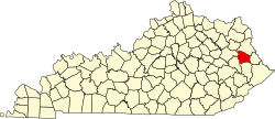
| County | Johnson |
| Elevation | 772 ft (235 m) |
| Time zone | UTC-5 (Eastern (EST)) |
| • Summer (DST) | UTC-4 (EDT) |
| GNIS feature ID | 507419 |
Asa is an unincorporated community in Johnson County, Kentucky, United States. It is located at an elevation of 772 feet (220 m). [1] Asa is located in the 41222 ZIP Code Tabulation Area. Weekly happenings in Asa are chronicled in Elaine Brown's Asa Creek News column in The Paintsville Herald .