
Southeast Alaska, colloquially referred to as the Alaska(n) Panhandle, is the southeastern portion of the U.S. state of Alaska, bordered to the east and north by the northern half of the Canadian province of British Columbia. The majority of Southeast Alaska's area is part of the Tongass National Forest, the United States' largest national forest. In many places, the international border runs along the crest of the Boundary Ranges of the Coast Mountains. The region is noted for its scenery and mild, rainy climate.

Kentucky, officially the Commonwealth of Kentucky, is a state in the Southeastern region of the United States and one of the states of the Upper South. It borders Illinois, Indiana, and Ohio to the north, West Virginia to the northeast, Virginia to the east, Tennessee to the south, and Missouri to the west. Its northern border is defined by the Ohio River. Its capital is Frankfort, and its two largest cities are Louisville and Lexington. Its population was approximately 4.5 million in 2020.

Bourbon is a type of barrel-aged American whiskey made primarily from corn. The name derives from the French Bourbon dynasty, although the precise source of inspiration is uncertain; contenders include Bourbon County in Kentucky and Bourbon Street in New Orleans, both of which are named after the dynasty. The name bourbon was not applied until the 1850s, and the Kentucky etymology was not advanced until the 1870s.

Totem poles are monumental carvings found in western Canada and the northwestern United States. They are a type of Northwest Coast art, consisting of poles, posts or pillars, carved with symbols or figures. They are usually made from large trees, mostly western red cedar, by First Nations and Indigenous peoples of the Pacific Northwest Coast including northern Northwest Coast Haida, Tlingit, and Tsimshian communities in Southeast Alaska and British Columbia, Kwakwaka'wakw and Nuu-chah-nulth communities in southern British Columbia, and the Coast Salish communities in Washington and British Columbia.

Sitka is a unified city-borough in the southeast portion of the U.S. state of Alaska. It was formerly known as New Archangel while under Russian rule from 1799 to 1867. The city is situated on the west side of Baranof Island and the south half of Chichagof Island in the Alexander Archipelago of the Pacific Ocean. As of the 2020 census, Sitka had a population of 8,458, the fifth-most populated city in the state.

Johnson County is a county located in the U.S. state of Kentucky. As of the 2020 census, the population was 22,680. Its county seat is Paintsville. The county was formed in 1843 and named for Richard Mentor Johnson, War of 1812 general, United States Representative, Senator, and Vice President of the United States. Johnson County is classified as a moist county, which is a county in which alcohol sales are not allowed, but containing a "wet" city, in this case Paintsville, where alcoholic beverage sales are allowed.
Port Alexander is a city at the southeastern corner of Baranof Island in Prince of Wales-Hyder Census Area, Alaska, United States. At the 2010 census the population was 52, down from 81 in 2000.
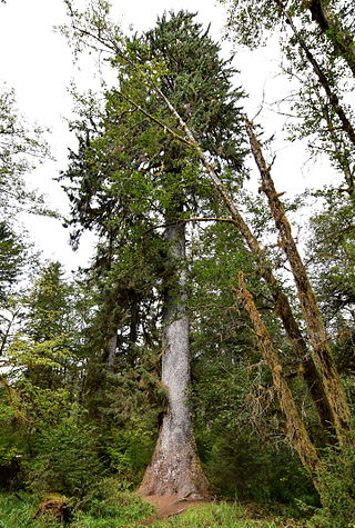
Picea sitchensis, the Sitka spruce, is a large, coniferous, evergreen tree growing to almost 100 meters (330 ft) tall, with a trunk diameter at breast height that can exceed 5 m (16 ft). It is by far the largest species of spruce and the fifth-largest conifer in the world, and the third-tallest conifer species. The Sitka spruce is one of the few species documented to exceed 90 m (300 ft) in height. Its name is derived from the community of Sitka in southeast Alaska, where it is prevalent. Its range hugs the western coast of Canada and the US, continuing south into northernmost California.

Alaska Day is a legal holiday in the U.S. state of Alaska, observed on October 18. It is the anniversary of the formal transfer of territories in present-day Alaska from the Russian Empire to the United States, which occurred on Friday, October 18, 1867.

Sitka National Historical Park is a national historical park in Sitka in the U.S. state of Alaska. It was redesignated as a national historical park from its previous status as national monument on October 18, 1972. The park in its various forms has sought to commemorate the Tlingit and Russian experiences in Alaska.
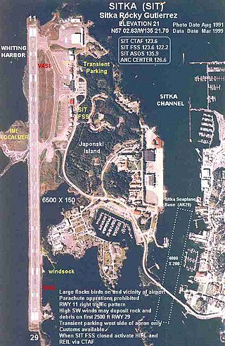
Sitka Rocky Gutierrez Airport is a state-owned, public-use airport located west of the central business district of Sitka, a city and borough in the U.S. state of Alaska.
The Saint Lazaria Wilderness or St. Lazaria Island is a nesting bird colony located twenty miles (32 km) west of Sitka, Alaska and is a part of the Gulf of Alaska unit of the Alaska Maritime National Wildlife Refuge. It is located in Sitka Sound, just south of Kruzof Island, and within the limits of the City and Borough of Sitka, Alaska. The island's name is Kanasx'ée in the Tlingit language.

Blue Lake is a 3 miles (4.8 km) long reservoir located 6 miles (9.7 km) east of the town of Sitka, on the west side of Baranof Island, in the Alexander Archipelago of Southeast Alaska.

USCGC Maple (WLB-207) is a Juniper-class seagoing buoy tender operated by the United States Coast Guard. She was based at Sitka, Alaska for 16 years and is currently homeported at Atlantic Beach, North Carolina. Her primary mission is maintaining aids to navigation, but she also supports search and rescue, law enforcement, oil spill response, and other Coast Guard missions.
Cape Meares National Wildlife Refuge is a National Wildlife Refuge of the Oregon Coast. It is one of six National Wildlife Refuges in the Oregon Coast National Wildlife Refuge Complex. Located on Cape Meares, the refuge was established in 1938 to protect a remnant of coastal old-growth forest and the surrounding habitat used by breeding seabirds. The area provides a home for a threatened bird species, the marbled murrelets. Peregrine falcons, once at the brink of extinction, have nested here since 1987. The refuge, with the exception of the Oregon Coast Trail, was designated a Research Natural Area in 1987.

Castle Hill also known as the American Flag-Raising Site and now as the Baranof Castle State Historic Site, is a National Historic Landmark and state park in Sitka, Alaska. The hill, providing a commanding view over the city, is the historical site of Tlingit and Russian forts, and the location where Russian Alaska was formally handed over to the United States in 1867. It is also where the 49-star United States flag was first flown after Alaska became a state in 1959.
Montgomery Pike Berry was a collector of customs for the United States Department of the Treasury, and from June 14, 1877, to August 13, 1877, was the highest-ranking federal official in the Department of Alaska, making him the de facto governor of the territory.
Sitka, Alaska is a unified city-borough in the southeast portion of the U.S. state of Alaska.
Sitka Seaplane Base is a public use seaplane base owned by and located in Sitka, a city and borough in the U.S. state of Alaska. It is included in the National Plan of Integrated Airport Systems for 2011–2015, which categorized it as a general aviation facility. This seaplane base is located near the Sitka Rocky Gutierrez Airport.
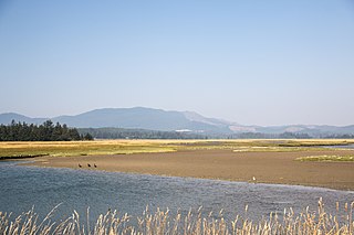
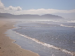
Sitka Sedge State Natural Area is an estuary and beach on the north coast of the U.S. state of Oregon in Tillamook County. Sitka Sedge consists of 357 acres (144 ha) of tidal marsh, mudflats, dunes, forested wetlands, and uplands at the south end of the Sand Lake estuary, north of Tierra Del Mar.


