
Johnson County is a county located in the U.S. state of Kentucky. As of the 2020 census, the population was 22,680. Its county seat is Paintsville. The county was formed in 1843 and named for Richard Mentor Johnson, a colonel of the War of 1812, United States Representative, Senator, and Vice President of the United States.
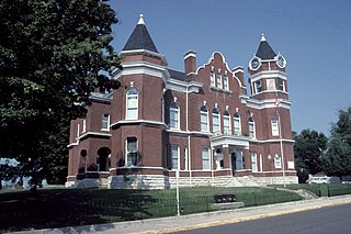
Fulton County is the westernmost county in the U.S. state of Kentucky, with the Mississippi River forming its western boundary. As of the 2020 census, the population was 6,515. Its county seat is Hickman and its largest city is Fulton. The county was formed in 1845 from Hickman County, Kentucky and named for Robert Fulton, the inventor of the steamboat.
Mayfield is a town in Fulton County, New York, United States, northeast of Gloversville and Johnstown. The town contains a village also named Mayfield. The population of the town was 6,495 at the 2010 census.

Jackson is a town in Washington County, Wisconsin, United States. The population was 3,516 at the 2000 census. The Village of Jackson is located partially within the town. The unincorporated community of Kirchhayn is also located in the town.

Jackson is a village in Washington County, Wisconsin, United States. The population was 7,185 at the 2020 census. The village is adjacent to the Town of Jackson.

The University of Kentucky is a public land-grant research university in Lexington, Kentucky. Founded in 1865 by John Bryan Bowman as the Agricultural and Mechanical College of Kentucky, the university is one of the state's two land-grant universities and the institution with the highest enrollment in the state, with 30,545 students as of fall 2019.
Jane Elliott is an American diversity educator. As a schoolteacher, she became known for her "Blue eyes/Brown eyes" exercise, which she first conducted with her third-grade class on April 5, 1968, the day after the assassination of Martin Luther King Jr. The publication of compositions which the children had written about the experience in the local newspaper led to much broader media interest in it.
Neatsville is an unincorporated community in Adair County, in the U.S. state of Kentucky. It is located at the junction of Kentucky Route 206 and Kentucky Route 76. Its elevation is 705 feet (215 m). For unknown reasons, the town's name was spelled as Neetsville from 1876 until 1886, when the town's post office closed. In its early history from around the 1810s to 1900, Neatsville progressively grew to become a well-established, incorporated town. It has been relocated twice through the years, once due to flooding circa 1900–1902, which decimated the town, and once in the 1960s when the Green River was impounded to make way for the Green River Reservoir.
Saint-Hilaire is a civil parish in Madawaska County, New Brunswick, Canada.
The Corn Bowl Conference was a high school athletic conference in based north central Iowa. The conference is made up of 1A and 2A schools, the two smallest classification of schools in Iowa.
Barthell is a former coal town in McCreary County, Kentucky, United States. It was established in 1902 and was the first of 18 mining camps to be built by the Stearns Coal and Lumber Company. It now serves as an open-air history museum, which is open from April through Thanksgiving.
Riceville is an unincorporated community in Pittsylvania County, in the U.S. state of Virginia.

Riceville is an unincorporated community and census-designated place (CDP) in McMinn County, Tennessee, United States. It is located some 60 miles southwest of Knoxville, and midway between Knoxville and Chattanooga, and in closer proximity, between Athens and Calhoun. Its population was 688 as of the 2020 census.
Raymond Milton Conger was an American middle-distance runner. He held the world record for the 1,000 yards and the American record for the 1,500 metres. In the U.S. national championships, Conger was a three-time winner in both the 1,000 yd and the mile run. At the 1928 Summer Olympics in Amsterdam, he won his qualifying heat for the 1,500 m but did not finish in the final.
Riceville is an unincorporated community in Fulton County, Kentucky, United States.
Riceville is an unincorporated community in Crawford County, Indiana, in the United States.
Riceville is an unincorporated community and census-designated place (CDP) in Cascade County, Montana, United States. It is in the southeastern part of the county, along U.S. Route 89 in the valley of Belt Creek, at the northern edge of the Little Belt Mountains. Via US-89, Riceville is 13 miles (21 km) south of Belt, 34 miles (55 km) southeast of Great Falls, and 64 miles (103 km) north of White Sulphur Springs.
Bailey was a community in Wayne Township, Mitchell County, Iowa, United States. Founded in 1886 as a whistle stop, it was briefly known as Wapsie. The community lay north of the Wapsipinicon River.


