Flat Gap, Kentucky

Last updated

Flat Gap, Kentucky
USA Kentucky location map.svg
Red pog.svg
Flat Gap
Usa edcp location map.svg
Red pog.svg
Flat Gap
Coordinates: 37°56′03″N82°53′15″W / 37.93417°N 82.88750°W / 37.93417; -82.88750
Country United States
State Kentucky
County Johnson
Elevation
815 ft (248 m)
Population
 (2000)
  Total1,920
Time zone UTC-5 (Eastern (EST))
  Summer (DST) UTC-4 (EDT)
ZIP codes
41219

Flat Gap (historically spelled Flatgap) is an unincorporated community in Johnson County, Kentucky, United States. The community was named after the "flat gap" formed at the divide between the Lower Laurel and Mudlick Creeks. Flat Gap's first post office was established on February 26, 1873, with Henry Jayne as postmaster. [1] Its ZIP code is 41219.

Contents

Geography

Flat Gap has an elevation of 815 feet (248 m). [2]

On June 2, 1990, one of the only tornadoes in Johnson County's history, touched down in Flat Gap at 1900. CST (7:00 p.m.) eastern time. The F1 tornado was 69 feet (23 yds) wide and created a one-mile (1.6 km) path of destruction. It caused an estimated $250,000 in damages. The only other recorded tornado happened on March 2, 2012, with widespread damage. [3]

Demographics

As of the census of 2000, [4] there were 1,920 people, 732 households, and 574 families residing in the ZIP Code Tabulation Area for Flat Gap's ZIP code. The racial makeup of the ZCTA was 99.4% White, 0.2% African American, 0.2% Alaska Native/American Indian, 0.1% from other races, and 0.2% from two or more races. Hispanic or Latino of any race were 0.5% of the population.

There were 732 households, out of which 21.7% had children under the age of 18 living with them, 66.5% were married couples living together, 8.2% had a female householder with no husband present, and 21.6% were non-families. 19.7% of all households were made up of individuals, and 26.9% had someone living alone who was 65 years of age or older. The average household size was 2.62 and the average family size was 3.00.

The median income for a household was $23,409, and the median income for a family was $27,729. Males had a median income of $28,531 versus $20,179 for females. The per capita income was $13,483. About 21.9% of the families were below the poverty line.

Education

Most students residing in Flat Gap attend: [5]

Related Research Articles

<span class="mw-page-title-main">Morgan County, Kentucky</span> County in Kentucky, United States

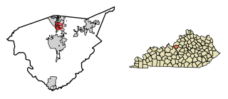
Morgan County is a county located in the U.S. state of Kentucky. As of the 2020 census, the population was 13,726. Its county seat is West Liberty. The county is among the dry counties, which means that the sale of alcohol is restricted or prohibited.

<span class="mw-page-title-main">Lincoln County, Kentucky</span> County in Kentucky, United States

Lincoln County is a county located in south-central Kentucky. As of the 2020 census, the population was 24,275. Its county seat is Stanford. Lincoln County is part of the Danville, KY Micropolitan Statistical Area.

<span class="mw-page-title-main">Fisher, Illinois</span> Village in Illinois, United States

Fisher is a village in Champaign County, Illinois, United States, that was founded in 1875. The population was 1,881 at the 2010 census.

<span class="mw-page-title-main">Henryville, Indiana</span> Census-designated place in Indiana, United States

Henryville is a census-designated place (CDP) in Monroe Township, Clark County, in the U.S. state of Indiana. The population was 1,905 at the 2010 census.

<span class="mw-page-title-main">Scottsburg, Indiana</span> City in Indiana, United States

Scottsburg is a city within Vienna Township and the county seat of Scott County, in the U.S. state of Indiana, about 30 miles (48 km) north of Louisville, Kentucky. The population of Scottsburg was 7,345 at the 2020 census.

<span class="mw-page-title-main">Fox Chase, Kentucky</span> City in Kentucky, United States

Fox Chase is a home rule-class city in Bullitt County, Kentucky, in the United States. It was formally incorporated by the state assembly in 1983. The population was 436 as of the 2020 census, down from 447 in the 2010 census.

<span class="mw-page-title-main">Mayfield, Kentucky</span> City in Kentucky, United States

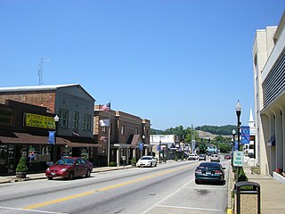
Mayfield is a home rule–class city and the county seat of Graves County, Kentucky, United States. The population was 10,017 as of the 2020 United States Census.

<span class="mw-page-title-main">Mortons Gap, Kentucky</span> City in Kentucky, United States

Mortons Gap is a home rule-class city in Hopkins County, Kentucky, in the United States. The population was 728 at the 2020 census, down from 863 at the 2010 census.

<span class="mw-page-title-main">West Liberty, Kentucky</span> City in Kentucky, United States

West Liberty is a home rule-class city in Morgan County, Kentucky, United States. It is the county seat of Morgan County. As of the 2020 census, the city population was 3,215. It is located along the Licking River at the junction of Kentucky Route 7 and U.S. Route 460.

<span class="mw-page-title-main">River Bluff, Kentucky</span> City in Kentucky, United States

River Bluff is a home rule-class city in Oldham County, Kentucky, United States. The population was 403 at the 2010 census.

<span class="mw-page-title-main">Kaplan, Louisiana</span> City in Louisiana, United States

Kaplan is a city in Vermilion Parish, Louisiana, United States. The population was 4,600 at the 2010 census, and 4,345 at the 2020 population estimates program. It is part of the Abbeville micropolitan statistical area in Acadiana.

<span class="mw-page-title-main">Greenfield, Minnesota</span> City in Minnesota, United States

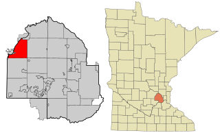
Greenfield is a city in northwestern Hennepin County, Minnesota. It has a population of 2,903 residents, according to the 2020 United States Census, and is located 26.5 miles northwest of Minneapolis. It is part of the Twin Cities Metropolitan Statistical Area.

<span class="mw-page-title-main">Fayetteville, Tennessee</span> City in Tennessee, United States

Fayetteville is a city and the county seat of Lincoln County, Tennessee, United States. The population was 6,994 at the 2000 census, and 6,827 at the 2010 census. A census estimate from 2018 showed 7,017.

Van Lear is an unincorporated community and coal town in Johnson County, Kentucky, United States.

Hager Hill (also Hagerhill) is an unincorporated community in Johnson County, Kentucky, United States. Hager Hill is located approximately four miles south of Paintsville, the county seat of Johnson County.

<span class="mw-page-title-main">Knox County, Kentucky</span> County in Kentucky, United States

Knox County is a county located in Appalachia near the southeastern corner of the U.S. state of Kentucky. As of the 2020 census, the population was 30,193. Its county seat is Barbourville. The county is named for General Henry Knox. It is one of the few coal-producing counties in Kentucky that has not suffered massive population loss. Knox County is included in the London, KY Micropolitan Statistical Area.

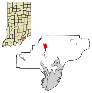
Oil Springs is an unincorporated community in Johnson County, Kentucky, United States. It lies along Route 40 west of the city of Paintsville, the county seat of Johnson County. It has a post office with the ZIP code 41238.

<span class="mw-page-title-main">Tutor Key, Kentucky</span> Unincorporated community in Kentucky, United States

Tutor Key is an unincorporated community in Johnson County, Kentucky, United States about 4.5 miles northeast of Paintsville. Tutor Key was originally known as Mingo.

Staffordsville is an unincorporated community in Johnson County, Kentucky, United States. The community was originally named Frew and the first post office was established on July 14, 1882, with Millard F. Rule as postmaster but in 1893, postmistress Jessie Stafford changed the post office's name to "Staffordsville" in order to honor her family. Staffordsville's ZIP code is 41256.

Wittensville is an unincorporated community in Johnson County, Kentucky, United States. Wittensville's ZIP code is 41274. It has a United States Postal Service, which stands besides a Dollar General which was constructed in June 2019. It also has an East Kentucky Realty estate agency.

References

  1. Rennick, Robert M. (1987). Kentucky Place Names. University Press of Kentucky. p. 102. ISBN   0813126312 . Retrieved April 28, 2013.
  2. www.tageo.com http://www.tageo.com . Retrieved June 3, 2009.{{cite web}}: Missing or empty |title= (help)[ title missing ]
  3. www4.ncdc.noaa.gov http://www4.ncdc.noaa.gov/cgi-win/wwcgi.dll?wwevent~ShowEvent~60075 . Retrieved January 28, 2010.{{cite web}}: Missing or empty |title= (help)[ title missing ]
  4. "U.S. Census website". United States Census Bureau . Retrieved January 31, 2008.
  5. www.johnson.k12.ky.us http://www.johnson.k12.ky.us/ . Retrieved June 3, 2009.{{cite web}}: Missing or empty |title= (help)[ title missing ]