Downtown Louisville

Last updated

The Louisville skyline Louisville Skyline 2021 (3).jpg
The Louisville skyline
400 West Market AEGON Center.JPG
400 West Market

Downtown Louisville is the largest central business district in the Commonwealth of Kentucky and the urban hub of the Louisville, Kentucky Metropolitan Area. Its boundaries are the Ohio River to the north, Hancock Street to the east, York and Jacob Streets to the south, and 9th Street to the west. As of 2015, the population of downtown Louisville was 4,700, although this does not include directly surrounding areas such as Old Louisville, Butchertown, NuLu, and Phoenix Hill.

Contents

The five main areas of the Central Business District consist of:

The tallest buildings in Kentucky are located in downtown Louisville and include 400 West Market designed by John Burgee, PNC Tower designed by Harrison & Abramovitz, PNC Plaza designed by Welton Becket, and the Humana Building designed by Michael Graves. Of the 16 buildings in Kentucky over 300 feet (91 m), 12 are in downtown Louisville. In addition, it is the center of local and regional government.

A glassed-in skywalk called the Louie Link stretches six city blocks and links together the Kentucky International Convention Center (KICC), Fourth Street Live!, three hotels (Galt House Hotel & Suites, Marriott and Hyatt Regency), and 2,300 hotel rooms. In 2010 it was extended from the Galt House to the new $16 million Skywalk Garage, an eight-level, 860-space parking facility on Third Street, and a second skywalk connects from the garage across Third Street to the new KFC Yum! Center.

History

The Richardsonian Romanesque Levy Building, built in 1893, an example of downtown Louisville's classic architecture and revitalization; the upper four floors have been converted to 23 loft condominiums Levy building louisville.jpg
The Richardsonian Romanesque Levy Building, built in 1893, an example of downtown Louisville's classic architecture and revitalization; the upper four floors have been converted to 23 loft condominiums

Downtown Louisville is the oldest part of the city of Louisville, whose initial development was closely tied to the Ohio River. The largest early fort, Fort Nelson, was built in 1781 near what is today the corner of 7th and Main streets. Many early residents lived nearby after moving out of the forts by the mid-1780s, although little remains of the earliest (mostly wood) structures.

Early plans of the city, such as William Pope's original plan in 1783, show a simple grid on an east–west axis along the river. The earliest streets, Main, Market and Jefferson retain their original names from the plan, while the smaller Green Street is now known as Liberty (it was renamed after Green Street acquired a seedy reputation due to its many burlesque theaters). Main Street was the city's initial commercial hub for nearly a century.

By 1830, Louisville passed Lexington as Kentucky's largest city, with a population over 10,000. The steamboat era saw the opening of the Louisville and Portland Canal just west of downtown, and local commerce picked up further with the founding of banks and manufacturing. Most of Louisville's population was packed into downtown, which by this time stretched as far south as Prather Street (later renamed Broadway). Many still-remaining buildings reveal what the area was like at this time, with narrow, two to four-story buildings packing the streets.

The area and the city continued to grow during the railroad era. However, the increased mobility of early trolleys, as well as the sheer number and diversity of people moving to Louisville, saw a shift in focus as areas like Phoenix Hill, Russell and what is now Old Louisville began to be built on the edges of downtown, particularly after the city annexed those areas in 1868. Railroads lead to a diminished role for the river in transportation, further reducing the importance of downtown in favor of areas on what was then the edge of the city, along rail lines.

In 1886, the first skyscraper, [1] the Kenyon Building, was completed on Fifth Street, followed in 1890 by the ten-story Columbia Building. The development of three large suburban parks and the electrified streetcar lead to the first true movement to the suburbs at this time. Some of downtown's business and industry followed people toward these areas. But by the 1920s the commercial center of Louisville was still nearby, at 4th and Broadway, dubbed the "magic corner" by the Herald-Post . The riverfront area of downtown was still being actively improved, such as with the building of what is now George Rogers Clark Memorial Bridge across the Ohio at Second Street in 1929.

After World War II, suburbanization increased and downtown began to decline as interstate highways further reduced the importance of its central location. Since the 1970s, downtown has been the subject of both urban renewal and historic preservation efforts. While many new buildings have been built, it has sometimes been at the expense of older landmarks, such as the Tyler Block.

Many buildings sat totally or mostly vacant at this time, and some became dilapidated to the point where they burned down or had to be razed. Many riverfront industrial sites were abandoned or saw limited use, many were eventually redeveloped into Louisville Waterfront Park. Other issues in the 1970s through the early 1990s included a former theater district on Jefferson Street that had become dubbed the "porno district". The businesses there were seen by the city as an eyesore since they were so close to the convention center, and most were demolished or burned down by the late 1990s. A few adult book stores and bars remained in the general area as of 2007.

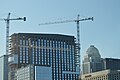
From the late 1970s to early 1990s, nine new high rises over 200 feet (61 m) in height were built in downtown. Unlike the city's previous tallest buildings, which were all set along the Broadway corridor, these new buildings were set closer to the riverfront along Main and Market Streets.

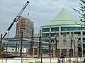
Since 2000, downtown has seen another major growth spurt, although this one not only includes new high rises, but also a large scale return of large scale residential and retail back to the city center. The completion of Louisville Slugger Field along with a mass expansion of the city's Waterfront Park, both completed in 1998, sparked new development along the eastern edge of downtown, with entire abandoned blocks rebuilt with new condominium units and shops. Also, new to Louisville is the 22,000-seat KFC Yum! Center at Second and Main Streets which was completed in 2010.

Residential

Example of an early downtown mansion, a Walnut Street mansion built by the Belknap family and used as the first clubhouse of the Pendennis Club before being razed Pendennis club c1906.jpg
Example of an early downtown mansion, a Walnut Street mansion built by the Belknap family and used as the first clubhouse of the Pendennis Club before being razed

Early residences outside of the forts, still mostly wood structures, were built along the modern street grid on early lots sold to settlers, but have all been demolished over time. What became the almost entirely office and parking-lot dominated downtown still had many solidly single family residential blocks on its fringes up until the early 20th century. Streets near Broadway, such as Chestnut, were lined with large mansions of the owners of businesses on Main and Market streets.

New development on East Main Street Louemaindev.jpg
New development on East Main Street

Though these houses were built of brick and other longer-lasting materials, none remained single family homes by the 21st century, although some had been converted for other uses, such as office space. The Brennan House at 631 S. Fifth, which is operated as a historic property with daily tours, shows a glimpse of downtown Louisville's residential past. A structure at 432 South Fifth Street is the only example of a pre-Civil War residence remaining downtown; built in 1829 it has been converted to commercial use. [2]

By the late 20th century, downtown Louisville had acquired a reputation as a place to work and visit during the week but which shuts down evenings and weekends. The first changes to this were the conversion of old warehouse and factory space to loft apartments in the late 1980s. By the late 1990s and early 2000s, new developments of luxury condominiums such as the 22-story Waterfront Park Place, and the $30 million project Fleur de Lis on Main, indicate increasing residential interest in downtown Louisville. On September 9, 2013, Mayor Greg Fischer joined groundbreaking ceremonies for the second phase of RiverPark Place, a marina apartment/condominium development covering 40 acres along River Road, with a walkway west to Waterfront Park. [3] In 1997, the Kentucky Towers was the largest residential building in downtown Louisville, [4] and in 2015, just south of downtown, The 800 Apartments started undergoing a more than $10 million modernization. [5] In 2007 downtown Louisville became Jefferson County's tenth Multiple Listing Service zone.

Liberty Greens will contain over 600 mixed-income housing units Loulibertygreens.jpg
Liberty Greens will contain over 600 mixed-income housing units

Housing units available downtown were expected to double between 2005 and 2010, from 1,800 to nearly 4,000, after increasing by only 900 units from 1985 to 2005. [6] This is both a result of new condominium construction and efforts to convert existing buildings into mixed usage, such as the $20 million redevelopment of the historic eight-story Henry Clay building at Third and Chestnut streets into a mix of residential, restaurant, retail and event space. The redevelopment also includes property that extends east to Fourth Street, which will become a public piazza, and the historic Wright-Taylor building, a two-story, 13,500-square-foot (1,250 m2) structure that faces Fourth Street and is located behind the Henry Clay, and is now an upscale restaurant that occupies the entire Wright-Taylor building.

Plans

Projects in the works include the construction of a wharf along the Riverwalk Trail, and the Ohio River Bridges Project, involving the reconstruction of Spaghetti Junction (the intersection of I-65, I-64 and I-71) along with the addition of a new bridge for northbound I-65 traffic. One recently completed project was the conversion of the former Big Four railroad bridge into a pedestrian and bicycle only bridge, which opened on the Kentucky side in 2013 and the Indiana side in 2014.

On August 19, 2007, city leaders and the Cordish Company, developers of 4th Street Live!, announced Center City, a $442 million, multi-year plan to develop 23 acres (93,000 m2), bounded by Second, Third and Liberty streets and Muhammad Ali Boulevard, that will include new housing, restaurants, a cinema and a boutique hotel. An estimated 500,000 square feet (46,000 m2) of floor space being created, including a 15-story structure. As the plan would require $130 million in local and state tax rebates for Cordish, it requires approval from the Louisville Metro Council and Kentucky General Assembly. There is no official start time for the project, as financing is still being secured by the Cordish Company. [7]

Also announced in 2007, the glass and steel $50 million shopping and office complex Iron Quarter was to be constructed within the Whiskey Row Historic District, but the project was delayed and eventually set aside when property owner Todd Blue made an agreement with the city of Louisville in January 2011 to demolish the seven original buildings. In May 2011, after all seven buildings had been landmarked, a new agreement was made with the city to save five of the seven buildings by donating one and selling the other four, with the remaining two to be demolished. Facades of all seven buildings are to be preserved. [8]

Attractions

Many attractions are located in downtown Louisville.

Images

Modern high rises

Tallest buildings in downtown Louisville

RankBuildingHeightFloorsYear completed/projectedStatus
1 400 West Market
(Capital Holding Center, Providian Center, AEGON Center)
549 ft (167 m)351993Completed
2 PNC Tower
(National City Tower)
512 ft (156 m)401972Completed
3 PNC Plaza
(Citizens Fidelity Plaza)
420 ft (128 m)311971Completed
4 (tie) Humana Building 417 ft (127 m)271984Completed
Omni Louisville Hotel302018Completed
6Waterfront Park Place364 ft (111 m)232004Completed
7 (tie)Meidinger Tower
(South Tower)
363 ft (110.6 m)261982Completed
Brown & Williamson Tower
(North Tower, Oxford Tower)
Completed
9 (tie)Waterfront Plaza I340 ft (103.6 m)251991Completed
Waterfront Plaza II1993Completed
11 LG&E Center
(One Corporate Plaza, LG&E Building)
328 ft (100 m)231989Completed
12 Galt House (West Tower)325 ft (99 m)251972Completed
13 Galt House (East Tower)322 ft (98 m)201985Completed
14 BB&T Building
(Louisville Trust Building, United Kentucky Building, Liberty Bank Building)
312 ft (95 m)241972Completed
15 The 800 Apartments 290 ft (88 m)291963Completed
16 (tie)Avenue Plaza Apartments
Metro Housing Authority
250 ft (76.2 m)181974Completed
Heyburn Building 171928Completed
18 (tie)J O Blanton House
U.S. Housing and Urban Development
246 ft (74.98 m)201972Completed
Hyatt Regency 181978Completed
Dosker Manor East and West
Metro Housing Authority
181968Completed
21Kentucky Home Life Building235 ft (71.6 m)191913Completed
22 (tie) Kentucky Towers 202 ft (61.5 m)181924Completed
Starks Building 141913Completed
24River View Place201 ft (61 m)191925
25Marriott Louisville200 ft (61 m)172005Completed
26 Brown Hotel 164 ft (49.99 m)161923Completed
27ZirMed Gateway Towers157.11 ft (47.89 m)122009Completed

See also

Related Research Articles

<span class="mw-page-title-main">Louisville, Kentucky</span> Largest city in Kentucky, United States

Louisville is the most populous city in the Commonwealth of Kentucky, sixth-most populous city in the Southeast, and the 27th-most-populous city in the United States. By land area, it is the country's 24th-largest city, although by population density, it is the 265th most dense city. Louisville is the historical county seat and, since 2003, the nominal seat of Jefferson County, on the Indiana border.

George Hargreaves is a landscape architect. Under his design direction, the work of his firm has received numerous national awards and has been published and exhibited nationally and internationally. He was an artist in residence at the American Academy of Rome in 2009. Hargreaves and his firm designed numerous sites including the master plan for the Sydney 2000 Olympics, The Brightwater Waste Water Treatment Facility in Seattle, Washington, and University of Cincinnati Master Plan.

<span class="mw-page-title-main">Downtown Pittsburgh</span> Neighborhood in Allegheny County, Pennsylvania, United States

Downtown Pittsburgh, colloquially referred to as the Golden Triangle, and officially the Central Business District, is the urban downtown center of Pittsburgh, Pennsylvania, United States. It is located at the confluence of the Allegheny River and the Monongahela River whose joining forms the Ohio River. The triangle is bounded by the two rivers.

<span class="mw-page-title-main">Downtown Kansas City</span> Place in Missouri, United States

Downtown Kansas City is the central business district (CBD) of Kansas City, Missouri and the Kansas City metropolitan area which contains 3.8% of the area's employment. It is between the Missouri River in the north, to 31st Street in the south; and from the Kansas–Missouri state line eastward to Bruce R. Watkins Drive as defined by the Downtown Council of Kansas City; the 2010 Greater Downtown Area Plan formulated by the City of Kansas City defines the Greater Downtown Area to be the city limits of North Kansas City and Missouri to the north, the Kansas–Missouri state line to the west, 31st Street to the south and Woodland Avenue to the east. However, the definition used by the Downtown Council is the most commonly accepted.

<span class="mw-page-title-main">Portland, Louisville</span>

Portland is a neighborhood and former independent town northwest of downtown Louisville, Kentucky. It is situated along a bend of the Ohio River just below the Falls of the Ohio, where the river curves to the north and then to the south, thus placing Portland at the northern tip of urban Louisville. In its early days it was the largest of the six major settlements at the falls, the others being Shippingport and Louisville in Kentucky and New Albany, Clarksville, and Jeffersonville on the Indiana side. Its modern boundaries are the Ohio River along the northwest, north, and northeast, 10th Street at the far east, Market Street on the south, and the Shawnee Golf Course at the far west.

<i>Belle of Louisville</i> Steamboat owned and operated by the city of Louisville, Kentucky

Belle of Louisville is a steamboat owned and operated by the city of Louisville, Kentucky, and moored at its downtown wharf next to the Riverfront Plaza/Belvedere during its annual operational period. The steamboat claims itself the "most widely traveled river steamboat in American history." Belle of Louisville's offices are aboard Mayor Andrew Broaddus, and also appears on the list of National Historic Landmarks.

<span class="mw-page-title-main">Downtown Memphis, Tennessee</span>

Downtown Memphis, Tennessee is the central business district of Memphis, Tennessee and is located along the Mississippi River between Interstate 40 to the north, Interstate 55 to the south and I-240 to the east, where it abuts Midtown Memphis.

<span class="mw-page-title-main">Galt House</span> Hotel in Louisville, Kentucky

TheGalt House Hotel is a 25-story, 1,300-room hotel in Louisville, Kentucky, established in 1972. It is named for a nearby historic hotel erected in 1835 and demolished in 1921. The Galt House is the city's only hotel on the Ohio River.

<span class="mw-page-title-main">Louisville Gardens</span> Arena in Kentucky, United States

Louisville Gardens is a multi-purpose, 6,000-seat arena, in Louisville, Kentucky, that opened in 1905, as the Jefferson County Armory. It celebrated its 100th anniversary as former city mayor Jerry Abramson's official "Family-Friendly New Years Eve" celebration location. It was added to the National Register of Historic Places in 1980.

<span class="mw-page-title-main">KFC Yum! Center</span> Multi-purpose indoor arena in Louisville, Kentucky, U.S.

The KFC Yum! Center is a multi-purpose indoor arena in Downtown Louisville, Kentucky, United States. It is named after the KFC restaurant chain and Yum! Brands, the parent company of KFC. Adjacent to the Ohio River waterfront, it is located on Main Street between 2nd and 3rd Streets and opened on October 10, 2010. The arena is part of a $450 million project that includes a 975-car parking structure and floodwall.

<span class="mw-page-title-main">Old Jeffersonville Historic District</span> Historic district in Indiana, United States

The Old Jeffersonville Historic District is located in Jeffersonville, Indiana, United States. It marks the original boundaries of Jeffersonville, and is the heart of modern-day downtown Jeffersonville. It was placed on the National Register of Historic Places in 1983. The area is roughly bounded by Court Avenue at the North, Graham Street on the east, the Ohio River at the south, and Interstate 65 at the west. In total, the district has 203 acres (0.8 km2), 500 buildings, 6 structures, and 11 objects. Several banks are located in the historic buildings in the district. The now defunct Steamboat Days Festival, held on the second weekend in September, used to be held on Spring Street and the waterfront. Jeffersonville's largest fire wiped out a block in the historic district on January 11, 2004, which destroyed the original Horner's Novelty store.

<span class="mw-page-title-main">West Main District, Louisville</span> United States historic place

The West Main District is one of the five districts of downtown Louisville, Kentucky. The district, or a portion of it, is listed in the National Register of Historic Places as West Main Street Historic District, due to its containment of some of the oldest structures in the city. The buildings of this district boast the largest collection of cast iron façades of anywhere outside New York's SoHo district. The district also features "Museum Row", a collection of several notable museums located within just a few blocks of each other.

<span class="mw-page-title-main">Downtown Columbus, Ohio</span> Neighborhood in Columbus, Ohio

Downtown Columbus is the central business district of Columbus, Ohio. Downtown is centered on the intersection of Broad and High Streets, and encompasses all of the area inside the Inner Belt. Downtown is home to most of the tallest buildings in Columbus.

<span class="mw-page-title-main">Downtown Norfolk, Virginia</span> Central Business District

Downtown Norfolk serves as the traditional center of commerce, government, and culture in the Hampton Roads region. Norfolk, Virginia's downtown waterfront shipping and port activities historically played host to numerous and often noxious port and shipping-related uses. With the advent of containerized shipping in the mid-19th century, the shipping uses located on Norfolk's downtown waterfront became obsolete as larger and more modern port facilities opened elsewhere in the region. The vacant piers and cargo warehouses eventually became a blight on downtown and Norfolk's fortunes as a whole. But in the second half of the century, Norfolk had a vibrant retail community in its suburbs; companies like Smith & Welton, High's, Colonial Stores, Goldman's Shoes, Lerner Shops, Hofheimer's, Giant Open Air, Dollar Tree and K & K Toys were regional leaders in their respective fields. Norfolk was also the birthplace of Econo-Travel, now Econo Lodge, one of the nation's first discount motel chains.

<span class="mw-page-title-main">Cityscape of Louisville, Kentucky</span>

Louisville, Kentucky is home to numerous structures that are noteworthy due to their architectural characteristics or historic associations, the most noteworthy being the Old Louisville neighborhood, the third largest historic preservation district in the United States. The city also boasts the postmodern Humana Building and an expanding Waterfront Park which has served to remove the former industrial appearance of the riverfront.

<span class="mw-page-title-main">Downtown Omaha</span> Central business district in Omaha

Downtown Omaha is the central business, government and social core of the Omaha–Council Bluffs metropolitan area, U.S. state of Nebraska. The boundaries are Omaha's 20th Street on the west to the Missouri River on the east and the centerline of Leavenworth Street on the south to the centerline of Chicago Street on the north, also including the CHI Health Center Omaha. Downtown sits on the Missouri River, with commanding views from the tallest skyscrapers.

The Clarksdale Housing Complex was a housing project located in Louisville, Kentucky directly east of downtown in the Phoenix Hill neighborhood.

The following is a timeline of the history of the city of Louisville, Kentucky, USA.

References

  1. Wiser, Stephen A. "History of Louisville Architectural Firms". AIA Central Kentucky. Archived from the original on February 8, 2012. Retrieved April 28, 2010.
  2. Louisville Guide (2004), p. 136
  3. "Officials Break Ground for Expanded River Park Place – Louisville.gov". September 9, 2013. Archived from the original on September 24, 2013.
  4. Nold, Chip; Bahr, Bob (1997). Insiders' Guide to Louisville, Kentucky & Southern Indiana, 2nd. Globe Pequot. p. 278. ISBN   978-1-57380-043-3 . Retrieved October 22, 2010.
  5. "Village Green CEO: 800 Apartments 'will be the best apartment building in Louisville'". Louisville Business First. June 19, 2015. Archived from the original on December 27, 2019. Retrieved June 3, 2016.
  6. "LouisvilleKy.gov - 2006 - Louisville's Downtown Alive with Development". louisvilleky.gov. October 1, 2006. Archived from the original on October 1, 2006. Retrieved December 6, 2011.
  7. Davis, Alex (August 19, 2007). "More in store for downtown". The Courier-Journal . Archived from the original on November 4, 2012. Retrieved July 6, 2017.
  8. "Fischer Announces Plans to Preserve Historic Whiskey Row". LouisvilleKY.gov. May 9, 2011. Archived from the original on September 20, 2011. Retrieved December 6, 2011.
  9. "SAR Genealogical Research Library". National Society Sons of the American Revolution. Archived from the original on October 9, 2015. Retrieved October 21, 2015.

Further reading

38°15′28.21″N85°45′41.99″W / 38.2578361°N 85.7616639°W / 38.2578361; -85.7616639