Related Research Articles
Fern Creek is a historic community in southeastern Jefferson County, Kentucky, United States. The population was 20,009 at the 2008 census. In 2003, The area was annexed to the city of Louisville as part of a merger between the city and Jefferson County's unincorporated communities. Fern Creek was formerly a census-designated place. It is now considered a neighborhood of Louisville. It is located about 12 miles from Downtown Louisville.

Spring Valley is a home rule-class city in Jefferson County, Kentucky, United States. The population was 654 at the 2010 census.
Valley Station is a former census-designated place in southwest Jefferson County, Kentucky, United States. It is known for housing the largest mobile home community in all of Jefferson County. The population was 22,946 at the 2000 census. When the government of Jefferson County merged with the city of Louisville, Kentucky in 2003, residents of Valley Station also became citizens of Louisville Metro. As a result, Valley Station is now a neighborhood within the city limits of Louisville. It was named for its location in the valley between Muldraugh Hill and the Knobs.
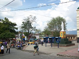
Santa Bárbara is a town and municipality in the Colombian department of Antioquia. Part of the subregion of Southwestern Antioquia. Santa Barbara is located in a valley about 2.5 hours drive from Medellín by car or bus.
Clifton Heights is a neighborhood two miles east of downtown Louisville, Kentucky USA. It was named because of its hilly location atop a ridge about 100 feet above the Ohio River floodplain, overlooking the adjacent community of Clifton. Though first planned in the 1890s as Summit Park, actual growth didn't begin until after World War I when automobiles made the hilly area accessible. Clifton Heights has had an African American presence since its founding, in 2000 they accounted for 21% of the population. Housing stock includes a variety of styles and time frames, from older shotgun houses and bungalows to suburban ranch homes built in the 1970s.
Audubon is a neighborhood in Louisville, Kentucky, United States. Its boundaries are Clarks Lane to the north, Poplar Level Road to the east, Preston Highway to the west, and the city of Audubon Park to the south. The smaller city of Parkway Village is surrounded by Audubon. George Rogers Clark Park, the site of a cabin owned by the parents of George Rogers Clark, is a prominent feature of the neighborhood.
Edgewood is a neighborhood on the south side of Louisville, Kentucky, United States. Its boundaries are Fern Valley Road to the south, I-65 to the west and Preston Highway to the north. Streets were laid out in the 1920s, but development was halted by the Great Depression. The area was also far from the city and had poor infrastructure. An improved sewage system after World War II and the large expansion of Standiford Field spurred development of Edgewood and its annexation by Louisville in 1957.
Hawthorne is a neighborhood in eastern Louisville, Kentucky, United States. Its boundaries are Taylorsville Road, Hawthorne Avenue, Bardstown Road and I-264. The land was once part of John Speed's Farmington estate, known for its plantation house built around 1815–16. The neighborhood is primarily residential and was first subdivided in 1909, but saw its fastest grown in the 1920s. It takes its name from Hawthorne Avenue, and most of the other streets are named after writers or poets. Sullivan University is located in the neighborhood.
Brownsboro-Zorn is a neighborhood in northeast Louisville, Kentucky, United States. Its boundaries are Brownsboro Road to the south, Birchwood Avenue to the west, Mellwood Avenue to the north, and Mockingbird Valley to the east. Residential development began in 1911 between Birchwood and Zorn Avenue, a wide street which bisects the neighborhood. The core of the neighborhood is residential, but there is substantial commerce along Brownsboro Road. The Veterans Affairs Medical Center is located along Zorn.

Louisville is a city in Jefferson County, in the U.S. state of Kentucky. It is located at the Falls of the Ohio River.
Waverly Hills is a neighborhood in Southwestern Louisville, Kentucky which is centered at Dixie Highway and Pages Lane. It is located in a hilly section of the city, which is part of the larger Knobs Region which extends into southeastern Kentucky. Its boundaries are roughly Stonestreet Road and 3rd Street Road to the south, Dixie Highway to the west, St Andrews Church Road to the north, and Auburndale to the east.
Bethany is a neighborhood of Louisville, Kentucky located on Dixie Highway by Bethany Cemetery.
Johnsontown is a neighborhood of Louisville, Kentucky located along Dixie Highway and Johnsontown Road.

Riverside Gardens is a neighborhood of Louisville, Kentucky centered along Campground Road and Lees Lane. In 2007, the first stretch of the proposed 110-mile Louisville Loop bike and pedestrian trail was completed to Lees Lane in Riverside Gardens from Riverview Park. The project included a $2 million bridge over Mill Creek. The concrete trail is expected to be connected to Shawnee Park by spring of 2008. In the future, a wharf and riverfront park is planned for Riverside Gardens.
Medora is a neighborhood of Louisville, Kentucky, centered along Pendleton Road and Medora Road.
Valley Village is a neighborhood of Louisville, Kentucky west of Dixie Highway and north of Bowen Avenue.
Sylvania is a neighborhood of Louisville, Kentucky located near Terry Road along Sylvania Road.
Valley Downs is a neighborhood of Louisville, Kentucky, USA located along Omar Khayyam Boulevard south of Johnsontown Road.
Valley High School is a high school in Louisville, Kentucky.
New Era is an unincorporated community in DeKalb County, Indiana, in the United States.
References
- ^ "HomeTownLocator" . Retrieved 2006-06-10.
Places in Louisville Metro | ||||||||||
|---|---|---|---|---|---|---|---|---|---|---|
| ||||||||||
City of Louisville and metro area | ||
|---|---|---|
| History |  | |
| Geography | ||
| Government |
| |
| Transportation | ||
| Other subject areas | ||
| Top subjects | ||
| National Historic Landmarks | ||
| Prominent suburbs (over 10K pop.) | ||
| | This Louisville-related article is a stub. You can help Wikipedia by expanding it. |
| | This Jefferson County, Kentucky state location article is a stub. You can help Wikipedia by expanding it. |