Keeneland, Lyndon, Kentucky

Last updated

Keeneland is also the name of a thoroughbred horse racing and sales complex in Lexington, Kentucky; for this complex, see Keeneland.
Keeneland
USA Kentucky location map.svg
Red pog.svg
Keeneland
Location within the state of Kentucky
Coordinates: 38°16′34″N85°33′59″W / 38.27611°N 85.56639°W / 38.27611; -85.56639
Country United States
State Kentucky
County Jefferson
Area
  Total
0.1 sq mi (0.2 km2)
  Land0.1 sq mi (0.2 km2)
  Water0.0 sq mi (0.0 km2)
Elevation
673 ft (205 m)
Population
 (2000)
  Total
383
  Density4,995.4/sq mi (1,928.7/km2)
Time zone UTC-5 (Eastern (EST))
  Summer (DST) UTC-4 (EDT)
FIPS code 21-41734
GNIS feature ID0495594

Keeneland is a former city in Jefferson County, Kentucky, United States, that was dissolved on January 1, 2001, and annexed by the neighboring City of Lyndon. Keeneland is now a neighborhood of Lyndon and also a part of Louisville Metro.

Contents

Geography

Keeneland is located at 38°16′34″N85°33′59″W / 38.27611°N 85.56639°W / 38.27611; -85.56639 (38.276020, -85.566448). [1]

According to the United States Census Bureau, the city has a total area of 0.1 square miles (0.26 km2), all of it land.

Demographics

As of the census [2] of 2000, there were 383 people, 156 households, and 104 families residing in the city. The population density was 4,995.3 inhabitants per square mile (1,928.7/km2). There were 157 housing units at an average density of 2,047.7 per square mile (790.6/km2). The racial makeup of the city was 95.56% White, 1.83% African American, 0.26% Asian, 0.52% from other races, and 1.83% from two or more races. Hispanic or Latino of any race were 1.57% of the population.

There were 156 households, out of which 35.3% had children under the age of 18 living with them, 52.6% were married couples living together, 14.1% had a female householder with no husband present, and 32.7% were non-families. 27.6% of all households were made up of individuals, and 9.0% had someone living alone who was 65 years of age or older. The average household size was 2.46 and the average family size was 3.03.

In the city the population was spread out, with 27.2% under the age of 18, 7.3% from 18 to 24, 36.0% from 25 to 44, 21.1% from 45 to 64, and 8.4% who were 65 years of age or older. The median age was 33 years. For every 100 females, there were 85.9 males. For every 100 females age 18 and over, there were 83.6 males.

The median income for a household in the city was $39,063, and the median income for a family was $41,667. Males had a median income of $28,500 versus $23,125 for females. The per capita income for the city was $18,248. About 6.9% of families and 6.8% of the population were below the poverty line, including 2.1% of those under age 18 and 9.3% of those age 65 or over.

Related Research Articles

<span class="mw-page-title-main">Hanceville, Alabama</span> City in Alabama, United States

Hanceville is a city in Cullman County, Alabama, United States. At the 2020 census, the population was 3,217.

<span class="mw-page-title-main">College Springs, Iowa</span> City in Iowa, United States

College Springs is a city in Page County, Iowa, United States. The population was 172 at the 2020 census.

<span class="mw-page-title-main">Lyndon, Kansas</span> City in Osage County, Kansas

Lyndon is a city in and the county seat of Osage County, Kansas, United States. As of the 2020 census, the population of the city was 1,037.

Cherrywood Village is a neighborhood and former city in Jefferson County, Kentucky, United States. Cherrywood Village was annexed by the City of St. Matthews in 2001. The population was 327 at the 2000 census.

Fairmeade is a neighborhood of St. Matthews, Kentucky. The population was 264 at the 2000 census.

<span class="mw-page-title-main">Moorland, Kentucky</span> City in Kentucky, United States

Moorland is a home rule-class city in Jefferson County, Kentucky, United States. The population was 431 as of the 2010 census.

Plymouth Village is a neighborhood of St. Matthews, Kentucky a city in Jefferson County, Kentucky, United States. The population was 201 at the 2000 census.

Whipps Millgate is a former city in Jefferson County, Kentucky, United States. The population was 415 at the 2000 census. The City of Whipps Millgate was incorporated on April 26, 1969, it was dissolved and annexed by the City of Lyndon, Kentucky on July 1, 2001.

<span class="mw-page-title-main">Wildwood, Kentucky</span> City in Kentucky, United States

Wildwood is a home rule-class city in Jefferson County, Kentucky, United States. The population was 261 at the 2010 census.

<span class="mw-page-title-main">Sunfish Lake, Minnesota</span> City in Minnesota, United States

Sunfish Lake is a city in Dakota County, Minnesota, United States. The population was 521 at the 2010 census. It was incorporated as a village in 1958.

<span class="mw-page-title-main">Twin Lakes, Freeborn County, Minnesota</span> City in Minnesota, United States

Twin Lakes is a city in Freeborn County, Minnesota, United States, near Albert Lea. The population was 134 at the 2020 census.

Carlisle Township is a township in Otter Tail County, Minnesota, United States. The population was 219 as of the 2000 census.

<span class="mw-page-title-main">Rockville, Missouri</span> City in Missouri, United States

Rockville is a city in Bates County, Missouri, and is part of the Kansas City metropolitan area within the United States. The population was 135 at the 2020 census.

<span class="mw-page-title-main">Asbury, Missouri</span> City in Missouri, United States

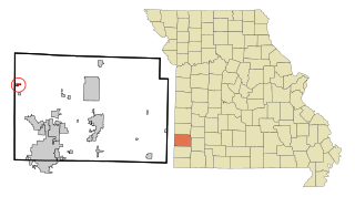
Asbury is a city in Jasper County, Missouri, United States. The population was 193 at the 2020 census. It is part of the Joplin, Missouri Metropolitan Statistical Area.

<span class="mw-page-title-main">Graham, Missouri</span> City in Missouri, United States

Graham is a city in southwestern Nodaway County, Missouri, United States. The population was 171 at the 2010 census.

<span class="mw-page-title-main">Nelson, Missouri</span> City in Missouri, United States

Nelson is a city in Saline County, Missouri, United States. The population was 152 at the 2020 census.

<span class="mw-page-title-main">Cooper Township, Montour County, Pennsylvania</span> Township in Pennsylvania, United States

Cooper Township is a township in Montour County, Pennsylvania, United States.

<span class="mw-page-title-main">President Township, Pennsylvania</span> Township in Pennsylvania, United States

President Township is a township in Venango County, Pennsylvania, United States. The population was 451 at the 2020 census, a decrease from 540 in 2010, which represented, in turn, a decrease from the figure of 543 at the 2000 census. It is located at the confluence of the Hemlock Creek and Allegheny River, and is largely made up of seasonal/recreational camps and cottages, which are situated near state gamelands.

<span class="mw-page-title-main">New Haven, West Virginia</span> Town in West Virginia, United States

New Haven is a town in Mason County, West Virginia, United States, along the Ohio River. The population was 1,485 at the 2020 census. It is part of the Point Pleasant, WV–OH Micropolitan Statistical Area.

<span class="mw-page-title-main">Fox Lake (town), Wisconsin</span> Town in Wisconsin, United States

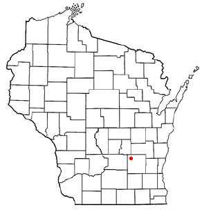
Fox Lake is a town in Dodge County, Wisconsin, United States. The population was 2,402 at the 2000 census. The City of Fox Lake is located within the town. The unincorporated communities of Delbern Acres, Fox Lake Junction, and Lyndon Dale are also located in the town.

References

  1. "US Gazetteer files: 2010, 2000, and 1990". United States Census Bureau. February 12, 2011. Retrieved April 23, 2011.
  2. "U.S. Census website". United States Census Bureau . Retrieved January 31, 2008.