Lewis and Clark Bridge | |
|---|---|
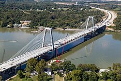
 The bridge in 2025 | |
| Coordinates | 38°20′34″N85°38′36″W / 38.3427°N 85.6433°W |
| Carries | 4 lanes of |
| Crosses | Ohio River |
| Locale | Prospect, Kentucky (Transylvania Beach) and Utica, Indiana – near Louisville, Kentucky |
| Maintained by | WVB East End Partners [1] |
| ID number | BH 57876 |
| Characteristics | |
| Design | Cable-stayed bridge |
| Total length | 2,500 ft (762 m) |
| Longest span | 1,200 ft (366 m) |
| History | |
| Opened | December 18, 2016 |
| Statistics | |
| Toll | |
| Location | |
 Interactive map of Lewis and Clark Bridge | |
The Lewis and Clark Bridge is a cable-stayed bridge that crosses the Ohio River northeast of downtown Louisville, Kentucky and is part of a ring road around the Louisville metropolitan area, connecting two previously disjointed segments of Interstate 265. It was known as the East End Bridge for 30 years since its conception and while under construction, and renamed by Indiana officials on the day of its opening, December 18, 2016. [2] The bridge provides for walking and bicycling. For motor vehicles, tolling began on December 30, 2016. [3]
Contents
The two "Clark" bridges in Louisville are named after different people: this bridge's name refers to William Clark of the Lewis and Clark Expedition, while the Clark Memorial Bridge in Downtown Louisville is named for his brother, George Rogers Clark. [4]