This article relies largely or entirely on a single source .(September 2019) |
Valley Downs is a neighborhood of Louisville, Kentucky, USA located along Omar Khayyam Boulevard south of Johnsontown Road.
This article relies largely or entirely on a single source .(September 2019) |
Valley Downs is a neighborhood of Louisville, Kentucky, USA located along Omar Khayyam Boulevard south of Johnsontown Road.
Valley Downs, Louisville is located at 38°6′50″N85°52′23″W / 38.11389°N 85.87306°W Coordinates: 38°6′50″N85°52′23″W / 38.11389°N 85.87306°W .
Valley Station is a former census-designated place in southwest Jefferson County, Kentucky, United States. It is known for housing the largest mobile home community in all of Jefferson County. The population was 22,946 at the 2000 census. When the government of Jefferson County merged with the city of Louisville, Kentucky in 2003, residents of Valley Station also became citizens of Louisville Metro. As a result, Valley Station is now a neighborhood within the city limits of Louisville. It was named for its location in the valley between Muldraugh Hill and the Knobs.

Meriwether is a neighborhood two miles southeast of downtown Louisville, Kentucky, USA, and just east of the University of Louisville. It was laid out by David Meriwether in 1871 and the first houses were built in 1891. Nearly all of the homes are shotgun houses.
Wilder Park is a neighborhood four miles south of downtown Louisville, Kentucky USA. The area was originally the site of Greenland race course, built in 1866, a sister track of Churchill Downs. Greenland track closed in 1888 and was subsequently used as a park.
Churchill Downs Incorporated is the parent company of Churchill Downs. The company has evolved from one racetrack in Louisville, Kentucky, to a multi American-state-wide, publicly traded company with racetracks, casinos and America‘s premier leading online wagering company among its portfolio of businesses.
Oakdale, occasionally called Wyandotte, is a neighborhood on the southside of Louisville, Kentucky, United States. Its modern boundaries are Longfield Avenue to the north, Taylor Boulevard to the west, I-264 to the south, and Southern Parkway to the east. The opening of Iroquois Park in the early 1890s created a huge demand for suburban homes south of Louisville. The Coleman-Bush company had begun selling lots in a subdivision called Oakdale in late 1890. Oakdale was one of many middle-class communities created at this time, facilitated by the southward extension of streetcar lines.

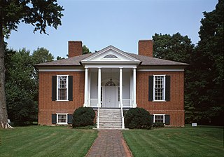
Hawthorne is a neighborhood in eastern Louisville, Kentucky, United States. Its boundaries are Taylorsville Road, Hawthorne Avenue, Bardstown Road and I-264. The land was once part of John Speed's Farmington estate, known for its plantation house built around 1815–16. The neighborhood is primarily residential and was first subdivided in 1909, but saw its fastest grown in the 1920s. It takes its name from Hawthorne Avenue, and most of the other streets are named after writers or poets. Sullivan University is located in the neighborhood.
Brownsboro-Zorn is a neighborhood in northeast Louisville, Kentucky, United States. Its boundaries are Brownsboro Road to the south, Birchwood Avenue to the west, Mellwood Avenue to the north, and Mockingbird Valley to the east. Residential development began in 1911 between Birchwood and Zorn Avenue, a wide street which bisects the neighborhood. The core of the neighborhood is residential, but there is substantial commerce along Brownsboro Road. The Veterans Affairs Medical Center is located along Zorn.

Caron is a hamlet in Saskatchewan, Canada, located on the south side of the Trans-Canada Highway, 26 kilometres west of Moose Jaw. It has a population of 120.

Louisville is a city in Jefferson County, in the U.S. state of Kentucky. It is located at the Falls of the Ohio River.
Greenwood is a neighborhood of Louisville, Kentucky located along Cane Run Road and Greenwood Road. It is sometimes referred to by its large industrial park and shipping facility, Riverport.
Bethany is a neighborhood of Louisville, Kentucky located on Dixie Highway by Bethany Cemetery.

Riverside Gardens is a neighborhood of Louisville, Kentucky centered along Campground Road and Lees Lane. In 2007, the first stretch of the proposed 110-mile Louisville Loop bike and pedestrian trail was completed to Lees Lane in Riverside Gardens from Riverview Park. The project included a $2 million bridge over Mill Creek. The concrete trail is expected to be connected to Shawnee Park by spring of 2008. In the future, a wharf and riverfront park is planned for Riverside Gardens.
Medora is a neighborhood of Louisville, Kentucky, centered along Pendleton Road and Medora Road.
Valley Village is a neighborhood of Louisville, Kentucky west of Dixie Highway and north of Bowen Avenue.
Valley Gardens is a neighborhood of Louisville, Kentucky, in the United States. It is centered along Johnsontown Road and Terry Road.
Sylvania is a neighborhood of Louisville, Kentucky located near Terry Road along Sylvania Road.

Allensville is an unincorporated community in Cotton Township, Switzerland County, in the U.S. state of Indiana.
Valley High School is a high school in Louisville, Kentucky.
The Louisville Astronomical Society (LAS) was founded in 1931 in Louisville, Kentucky by amateur astronomers, including James Gilbert Baker. Monthly meetings are held at 8:00 p.m. on the Third Tuesdays of each month. Monthly observing sessions, are held at the society's dark sky location, the James G. Baker Center for Astronomy in Curby, Indiana on the third Saturday of each month. They hold public star parties at their Urban Astronomy Center located in E. P. "Tom" Sawyer State Park on the Fourth Friday of every month. Star parties begin at dusk and are open to the public. The LAS has certified instructors for Boy Scout Astronomy requirements.
East Marion Precinct, formerly township, is Congressional Township 9 South, Range 3 East of the Third Principal Meridian located in Williamson County, Illinois. It is named for the community of Marion, Illinois.