Springlee, St. Matthews, Kentucky

Last updated

Springlee, Kentucky
USA Kentucky location map.svg
Red pog.svg
Springlee, Kentucky
Location within the state of Kentucky
Coordinates: 38°14′28″N85°38′32″W / 38.24111°N 85.64222°W / 38.24111; -85.64222
Country United States
State Kentucky
City St. Matthews
Area
  Total0.1 sq mi (0.2 km2)
  Land0.1 sq mi (0.2 km2)
  Water0.0 sq mi (0.0 km2)
Elevation
531 ft (162 m)
Population
 (2000)
  Total426
  Density5,281.6/sq mi (2,039.3/km2)
Time zone UTC-5 (Eastern (EST))
  Summer (DST) UTC-4 (EDT)
FIPS code 21-72750
GNIS feature ID0504162

Springlee is a neighborhood of St. Matthews, Kentucky, an area of Louisville. The population was 426 at the 2000 census. Until 2000 Springlee was an independent Sixth Class city in Jefferson County, Kentucky, United States. Springlee was incorporated on April 25, 1950. Springlee was dissolved on December 5, 2000, and annexed by the City of St. Matthews on January 8, 2001

Contents

Geography

Springlee is located at 38°14′28″N85°38′32″W / 38.24111°N 85.64222°W / 38.24111; -85.64222 (38.241220, -85.642246). [1]

According to the United States Census Bureau, the city has a total area of 0.1 square miles (0.26 km2), all of it land.

Demographics

As of the census [2] of 2000, there were 426 people, 209 households, and 112 families residing in the city. The population density was 5,281.6 inhabitants per square mile (2,039.2/km2). There were 217 housing units at an average density of 2,690.4 per square mile (1,038.8/km2). The racial makeup of the city was 97.18% White, 0.23% African American, 0.23% Asian, 0.23% from other races, and 2.11% from two or more races. Hispanic or Latino of any race were 1.41% of the population.

There were 209 households, out of which 26.8% had children under the age of 18 living with them, 42.6% were married couples living together, 9.1% had a female householder with no husband present, and 46.4% were non-families. 41.6% of all households were made up of individuals, and 16.7% had someone living alone who was 65 years of age or older. The average household size was 2.04 and the average family size was 2.80.

In the city, the population was spread out, with 21.6% under the age of 18, 3.3% from 18 to 24, 38.0% from 25 to 44, 22.5% from 45 to 64, and 14.6% who were 65 years of age or older. The median age was 38 years. For every 100 females, there were 79.7 males. For every 100 females age 18 and over, there were 71.3 males.

The median income for a household in the city was $46,136, and the median income for a family was $63,750. Males had a median income of $50,750 versus $36,875 for females. The per capita income for the city was $29,102. About 1.8% of families and 3.3% of the population were below the poverty line, including 4.5% of those under age 18 and 4.2% of those age 65 or over.

Related Research Articles

<span class="mw-page-title-main">Tarrant, Alabama</span> City in Alabama, United States

Tarrant is a city in Jefferson County, Alabama, bordering Birmingham to the north. At the 2020 census, the population was 6,124. It is home to the ABC Coke plant owned by the Drummond Company, "the largest single producer of foundry coke in the U.S.".

<span class="mw-page-title-main">Mākaha Valley, Hawaii</span> Census-designated place in Hawaii, United States

Mākaha Valley is a census-designated place (CDP) in Honolulu County, Hawaiʻi, United States. The population was 198 at the 2020 census.

<span class="mw-page-title-main">Morristown, Indiana</span> Town in Indiana, United States

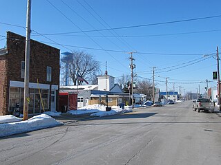
Morristown is a town in Hanover Township, Shelby County, in the U.S. state of Indiana. The population was 1,218 at the 2010 census.

Broad Fields is a neighborhood of St. Matthews, Kentucky. Broad Fields was a Sixth Class city in Jefferson County, Kentucky, United States. Broad Fields was incorporated on May 24, 1957. Broad Fields was dissolved on July 1, 2000, and annexed by St. Matthews on January 8, 2001. The population was 250 at the 2000 census.

Cherrywood Village is a neighborhood and former city in Jefferson County, Kentucky, United States. Cherrywood Village was annexed by the City of St. Matthews in 2001. The population was 327 at the 2000 census.

Fairmeade is a neighborhood of St. Matthews, Kentucky. The population was 264 at the 2000 census.

Plymouth Village is a neighborhood of St. Matthews, Kentucky a city in Jefferson County, Kentucky, United States. The population was 201 at the 2000 census.

Whipps Millgate is a former city in Jefferson County, Kentucky, United States. The population was 415 at the 2000 census. The City of Whipps Millgate was incorporated on April 26, 1969, it was dissolved and annexed by the City of Lyndon, Kentucky on July 1, 2001.

<span class="mw-page-title-main">Woodland Hills, Kentucky</span> City in Kentucky, United States

Woodland Hills is a home rule-class city in Jefferson County, Kentucky, United States. The population was 696 at the 2010 census.

<span class="mw-page-title-main">Salem, Kentucky</span> City in Kentucky, United States

Salem is a home rule-class city in Livingston County, Kentucky, in the United States. Salem is part of the Paducah micropolitan area. The population was 752 during the 2010 census, down from 769 in 2000. It the second-largest community in Livingston County, but the census-designated place of Ledbetter has more than twice the population of Salem.

<span class="mw-page-title-main">Algonquin, Maryland</span> Census-designated place in Maryland, United States

Algonquin is a census-designated place (CDP) in Dorchester County, Maryland, United States. The population was 1,241 at the 2010 census. The community was named for the Algonquin people, one of the Native American tribes in the East.

<span class="mw-page-title-main">Olivet, Michigan</span> City in Michigan, United States

Olivet is a city in Eaton County in the U.S. state of Michigan. The population was 1,605 at the 2010 census. Olivet College is located in the city.

<span class="mw-page-title-main">Iron River, Michigan</span> City in Michigan, United States

Iron River is a city in Iron County in the U.S. state of Michigan. As of the 2020 census, the city population was 3,007. The city is situated at the southeast corner of Iron River Township, but is administratively autonomous. Iron River is the birthplace and home of four-time US Olympian and 2022 gold medalist Nick Baumgartner.

<span class="mw-page-title-main">Matthews, Missouri</span> City in Missouri, United States

Matthews is a city in New Madrid County, Missouri, United States. The population was 628 at the 2010 census.

<span class="mw-page-title-main">Morehouse, Missouri</span> City in Missouri, United States

Morehouse is a city in New Madrid County, Missouri, United States. The population was 973 at the 2010 census.

<span class="mw-page-title-main">Cygnet, Ohio</span> Village in Ohio, United States

Cygnet is a village in Wood County, Ohio, United States. The population was 543 at the 2020 census.

<span class="mw-page-title-main">Cherryhill Township, Indiana County, Pennsylvania</span> Township in Pennsylvania, United States

Cherryhill Township is a township in Indiana County, Pennsylvania, United States. It was named for Cherry Hill Manor, which was surveyed to the Penns. The population was 2,477 at the 2020 census. It includes the communities of Buck Run, Hustonville, Ideal, Kenwood, Manor, Manver, Mitchell's Mills, Penn Run, Pikes Peak, Rembrandt, Sample Run, and Weimer. The township surrounds but does not include the borough of Clymer.

<span class="mw-page-title-main">Opportunity, Washington</span> Locale in Washington, United States

Opportunity is a locale and former census-designated place in Spokane County, Washington, United States. The population was 25,065 at the 2000 census.

<span class="mw-page-title-main">New Haven, West Virginia</span> Town in West Virginia, United States

New Haven is a town in Mason County, West Virginia, United States, along the Ohio River. The population was 1,485 at the 2020 census. It is part of the Point Pleasant, WV–OH Micropolitan Statistical Area.

<span class="mw-page-title-main">Warren, St. Croix County, Wisconsin</span> Town in Wisconsin, United States

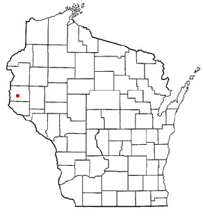
Warren is a town in St. Croix County, Wisconsin, United States. The population was 1,320 at the 2000 census. The village of Roberts is located within the town.

References

  1. "US Gazetteer files: 2010, 2000, and 1990". United States Census Bureau. February 12, 2011. Retrieved April 23, 2011.
  2. "U.S. Census website". United States Census Bureau . Retrieved January 31, 2008.