Related Research Articles
Fern Creek is a historic community in southeastern Jefferson County, Kentucky, United States. The population was 20,009 at the 2008 census. In 2003, The area was annexed to the city of Louisville as part of a merger between the city and Jefferson County's unincorporated communities. Fern Creek was formerly a census-designated place. It is now considered a neighborhood of Louisville. It is located about 12 miles from Downtown Louisville.
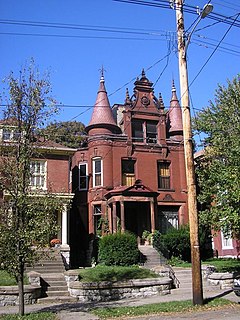
The Original Highlands is a historic neighborhood in the Highlands area of Louisville, Kentucky, United States.
Shawnee is a neighborhood in western Louisville, Kentucky. Its boundaries are the Ohio River on the West, Bank Street and the Portland neighborhood on the North, I-264 on the East, and West Broadway on the South. Maps sometimes identify the area as Shawneeland.

Crescent Hill is a neighborhood four miles (6 km) east of downtown Louisville, Kentucky USA. This area was originally called "Beargrass" because it sits on a ridge between two forks of Beargrass Creek. The boundaries of Crescent Hill are N Ewing Ave to the St. Matthews city limit by Brownsboro Road to Lexington Road. Frankfort Avenue generally bisects the neighborhood.

Shelby Park is a neighborhood two miles southeast of downtown Louisville, Kentucky USA named after Kentucky's first governor, Isaac Shelby. Shelby Park has always been considered a working-class neighborhood. It was first populated by German immigrants in the early 1900s. By the 1950s, the neighborhood was majority African American. Today, Shelby Park is a blend of ethnic and economic diversity. People from all walks of life co-exist in a vibrant, art-filled community.
Audubon is a neighborhood in Louisville, Kentucky, United States. Its boundaries are Clarks Lane to the north, Poplar Level Road to the east, Preston Highway to the west, and the city of Audubon Park to the south. The smaller city of Parkway Village is surrounded by Audubon. George Rogers Clark Park, the site of a cabin owned by the parents of George Rogers Clark, is a prominent feature of the neighborhood.
California is a neighborhood in urban Louisville, Kentucky, United States. It is bounded on the north by Broadway, on the east by Ninth Street, on the south by Oak Street, and on the west by Twenty-Sixth Street. There are no written records of the beginning of the neighborhood, but the area was settled by German immigrants around 1849. It is said that the subdivision, initially called Henderson, came to be known as California because it was the "far west" of Louisville.
Park DuValle is a neighborhood southwest of downtown Louisville, Kentucky. Its boundaries are I-264 to the west, the Norfolk Southern Railway tracks to the north, Cypress Street to the east, and Bells Lane and Algonquin Parkway to the south. The neighborhood reflects the presence of several nearby parks, and DuValle Junior High School, named after Lucie DuValle, the first female principal of a high school in Louisville.
Oakdale, occasionally called Wyandotte, is a neighborhood on the southside of Louisville, Kentucky, United States. Its modern boundaries are Longfield Avenue to the north, Taylor Boulevard to the west, I-264 to the south, and Southern Parkway to the east. The opening of Iroquois Park in the early 1890s created a huge demand for suburban homes south of Louisville. The Coleman-Bush company had begun selling lots in a subdivision called Oakdale in late 1890. Oakdale was one of many middle-class communities created at this time, facilitated by the southward extension of streetcar lines.
Kenwood Hill is a hill and neighborhood on the south side of Louisville, Kentucky, United States. Its boundaries are New Cut Road, Kenwood Drive, Southside Drive and Palatka Road. The hill, earlier known as Sunshine Hill and then Cox's Knob, was used by Native Americans to spot buffalo. By 1868 Benoni Figg owned the area as a part of his charcoal business. His family oversaw development on the land until it was sold in 1890 to a development company which named the area Kenwood Hill. Southern Parkway was opened soon after in 1893.
Iroquois is a neighborhood on the south side of Louisville, Kentucky, United States. It is split into two parts by Beechmont. The neighborhood is roughly bounded by Hazelwood Avenue, Beechmont, Third Street, Kenwood Drive, and Iroquois Park. Located near the Louisville International Airport, residents have frequently complained of noise and challenged airport expansion. The largely residential neighborhood was developed as a suburb after World War II and into the 1950s.
Hayfield-Dundee is a neighborhood in eastern Louisville, Kentucky. Its boundaries are Dundee Road, Emerson Avenue, Newburg Road, I-264, and Tremont Drive to the east. Prior to subdivision, much of the land had been part of the Hayfield Farm, owned by Dr. Charles Wilkens Short, a founding professor of the University of Louisville medical school.
Gardiner Lane is a neighborhood in eastern Louisville, Kentucky, United States. Its boundaries are Emerson Avenue to the north, Bardstown Road to the east, I-264 to the south, and Tremont Drive to the west. As with surrounding neighborhoods, it was farmland well into the first half of the 1900s. 16 subdivisions were developed from 1913 to 1950.
Hazelwood is a neighborhood on the south side of Louisville, Kentucky, United States. Its boundaries are Manslick Road to the west, I-264 to the north, Taylor Boulevard to the east, and Hazelwood Avenue to the south. Its development, as with other nearby neighborhoods, was spurred by the opening of Iroquois Park in the early 1890s. E.E. Meacham first subdivided the land in 1899. A larger subdivision, called Bergmann's Addition, was financed in 1902. The Hazelwood Center, opened in 1907, is a former tuberculous center and since 1971 a hospital for the mentally handicapped located in the neighborhood.
Bradley is a neighborhood two miles southeast of downtown Louisville, Kentucky, United States, and immediately east of the University of Louisville. The housing stock is mostly brick exterior craftsman style homes. Its boundaries are Eastern Parkway, Preston Highway, the Norfolk Southern Railway tracks, and I-65.
Beckley is a neighborhood of Louisville, Kentucky located along North Beckley Station Road and the Chenoweth Run watershed. It is sometimes referred to by its largest subdivision, Lake Forest.
Freys Hill is a neighborhood of the U.S. city of Louisville, Kentucky, located along Freys Hill Road and Westport Road. It is sometimes referred to by its largest subdivision and accompanying shopping center, Springhurst.
Waverly Hills is a neighborhood in Southwestern Louisville, Kentucky which is centered at Dixie Highway and Pages Lane. It is located in a hilly section of the city, which is part of the larger Knobs Region which extends into southeastern Kentucky. Its boundaries are roughly Stonestreet Road and 3rd Street Road to the south, Dixie Highway to the west, St Andrews Church Road to the north, and Auburndale to the east.
Prairie Village is a neighborhood of Louisville, Kentucky, composed of a series of subdivisions and farms centered on the intersection of Third Street Road, Valley Station Road, and Stonestreet Road.
Southside is a neighborhood in Louisville, Kentucky, United States. Its boundaries are Third Street to the west, Woodlawn Avenue, Allmond Avenue and Hiawatha Avenue to the north, the CSX railroad tracks to the east, and the southern boundary of the Greater Louisville Technology Park, Southside Drive and Kenwood Drive to the south.
References
- ↑ "Kentucky Public Library Directory". Kentucky Department for Libraries and Archives. Archived from the original on 11 January 2019. Retrieved 5 June 2019.
