Belknap, Louisville

Last updated
Belknap
Coordinates: 38°13′13″N85°41′08″W / 38.22030°N 85.68550°W / 38.22030; -85.68550
CountryUnited States
State Kentucky
City Louisville
ZIP code(s)
40205
Area code(s) 502
Website www.belknapneighborhood.org

Belknap is an urban neighborhood three and a half miles east of downtown Louisville, Kentucky, USA. The neighborhood is bound by Bardstown Road, Douglass Boulevard, Dundee Road and Newburg Road. It is part of a larger area of Louisville called the Highlands. Belknap is often described as the neighborhood in the heart of The Highlands.

Contents

History

Early history

The Belknap neighborhood was once farm land, two miles (3 km) south of where Bardstown Road (then Bardstown Turnpike) began at Highland Avenue. There was a stagecoach stop at Douglass Boulevard and Bardstown Road called the "Two-mile House." Abraham Lincoln frequented the stagecoach stop when he was visiting the Speed Family at Farmington.

As the city of Louisville grew, so did the Highlands. The Catholic parish St. Francis of Assisi built its first church on the Michael Zimlich property in 1886. Zimlich sold 24 acres (97,000 m2) in 1901, paving the way for one of the first commercial strips along Bardstown and Dundee roads. In 1909, the Eilers family sold a 22 foot (7 m) easement for the streetcar turnaround and the annexation of the loop occurred, now called Douglass Loop. Zimlich later sold 26 more acres, and between 1916 and 1918 Boulevard Napoleon was developed.

Belknap Research Building, University of Louisville Belknap Research Building, University of Louisville (1058).jpg
Belknap Research Building, University of Louisville

When 30 acres (120,000 m2) of adjacent property, owned by the Heintzmann family, was sold, it became the first section of University Park, so named because it would lead to the University of Louisville. The street names were changed in 1918 to Ivy League school names, such as Harvard and Yale, to connect to the new subdivision. However, a building bond to facilitate the new campus was rejected by voters in 1920, and the plan never materialized.

The original school on Sils Avenue was named for William Richardson Belknap (William Burke Belknap's son) and opened in 1916, two years after his death. When the school opened, it was a city school, but most of the area was still county. The county children had to go to Maple Grove, present day location of Air Devil's Inn, across from Bowman Field on Taylorsville Road.

1920s

In the 1920s, there was another annexation, and the final annexation occurred in 1958. The sixth class cities were incorporated in the 1920s, making Strathmoor Manor within the boundaries of the Belknap neighborhood.

In 1923, the University of Louisville sold their property, and the development style in the area changed. Some of the land was sold to William F. Randolph, who preferred the curvilinear features that followed the natural contours of the land and other developers followed his lead.

When the Fred Kaelin farm was auctioned from a mule truck in 1923, there were two homes on the property. One still stands on Eastview Avenue (since converted to apartments). The other was razed to build a Walgreens drug store at Bardstown Road and Trevilian Way. The stone part of a house on Lakeside Drive was originally the springhouse for the farm.

Lakeside Swim Club opened in 1924 at the site of a former rock quarry. This private club is known for its steep, 40 foot rock walls and huge quarry "lake" – actually a 3.2 million US gallon (12,000 m3) swimming pool, with a flat concrete bottom and depths ranging from 3 to 20 feet (6 meters).

1940s

The Trough Springs property once belonged to Jonathan Clark, brother of George Rogers and William Clark. It was built before Kentucky became a state. The Doup cemetery, at 2700 Bardstown Road, was incorporated in 1812. In 1949, Bellarmine University was founded in the area.

2010s

In 2010, Kroger petitioned the Louisville Metro Planning Commission to install a five bay gasoline station in the back of the old Hollywood Video store in the 2400 block of Bardstown Road. Kroger forecast the gasoline station would sell 50,000 gallons of gasoline each week at the proposed location behind homes located on Trevillian Way and Lakeside Drive. The Belknap Neighborhood Association opposed the gasoline station based upon existing binding elements prohibiting a gasoline station, expected impact on traffic, environment, property values and quality of life. The Louisville Metro Planning Commission considered the case in an epic five-and-a-half-hour meeting on August 19, 2010. The commission denied Kroger's request by a unanimous vote with one abstention. The denial is the first case in which Kroger was denied the ability to build a gas station in Kentucky.

The Belknap Neighborhood Association voted unanimously in 2011, to support the restoration and landmarking of the iconic Hogan's Fountain Pavilion in Cherokee Park. Belknap was the first Louisville neighborhood to come out in support of the E.J. Schickli masterpiece which is considered by residents the most recognizable landmark in the Louisville Highlands. Belknap made two financial donations in 2011, and 2012, to support the campaign to restore the TeePee and challenged all other Highland Neighborhood Associations to step up and do the same. The structure, otherwise known as the TeePee or Witch's Hat is officially named the McCall Shelter in honor of Alderman C.W. "Ches" McCall who was killed in an auto accident in 1962.

Architecture

The Belknap neighborhood has many styles and ages of houses, the different styles represent more than a century of development. Some include: Bungalow, Arts & Crafts Movement, American Foursquare, Antebellum and Dutch Colonial. A handful of antebellum structures remain, including a former farmhouse on Eastview Avenue (now apartments), and a barn behind a house near the Douglass Loop.

Recognition

Belknap was recognized by Louisville Magazine in October 2010 as one of the most livable and lovable neighborhoods in Louisville and Jefferson County, Kentucky. In 2012, the neighborhood received a national award from Neighborhoods, USA. The recognition by Neighborhoods, USA is the first time a Kentucky neighborhood was recognized by this organization.

A diverse and eclectic neighborhood, Belknap is rated as one of the most walkable neighborhoods in Louisville, based upon walkabilityscore.com. Belknap has one of the highest voter registrations of Democrats in all of Jefferson County and is ironically home to U.S. Senate Majority Leader Mitch McConnell and his wife Elaine Chao, former president of the United Way, director of the Peace Corps and United States Secretary of Labor.

Belknap Fall Festival

The Belknap Neighborhood Association stages the Belknap Fall Festival each year on the second Friday and Saturday of October. It has grown to become the largest Fall festival in the Louisville Highlands, in 2011 drawing a two-day crowd of 18,000 people. The festival showcases the work of over 100 artists, musicians, nonprofits, education organizations and community resources. The festival is produced completely by volunteers and proceeds raised go to support the mission of the Belknap Neighborhood Association - including neighborhood improvements.

Demographics

In the 2010 census, the population of Belknap was 4,730, making it the largest neighborhood in the Louisville Highlands. The population is comprised: 95.8% are white, 1.9% are people listed as other, 1.3% are black, and 1% are Hispanic. College graduates are 57.8% of the population, people without a high school diploma are 3.8%. Females outnumber males 55% to 45%. The Belknap neighborhood has the highest median household income of any neighborhood in the Louisville Highlands. It has the lowest percentage of homes in foreclosure, the highest percentage of owner occupied housing and the lowest percentage of households in poverty.

See also

Related Research Articles

<span class="mw-page-title-main">Louisville, Kentucky</span> Largest city in Kentucky, United States

Louisville is the most populous city in the Commonwealth of Kentucky, sixth-most populous city in the Southeast, and the 27th-most-populous city in the United States. By land area, it is the country's 24th-largest city, although by population density, it is the 265th most dense city. Louisville is the historical county seat and, since 2003, the nominal seat of Jefferson County, on the Indiana border.

<span class="mw-page-title-main">Cherokee Park</span> Municipal park in Louisville, KY, US

Cherokee Park is a 409-acre (166 ha) municipal park located in Louisville, Kentucky, United States and is part of the Louisville Olmsted Parks Conservancy. It was designed in 1891 by Frederick Law Olmsted, the father of landscape architecture along with 18 of Louisville's 123 parks. Beargrass Creek runs through much of the park, and is crossed by numerous pedestrian and automobile bridges.

<span class="mw-page-title-main">Deer Park, Louisville</span> Louisville neighborhood in Kentucky, United States

Deer Park is a neighborhood four miles southeast of downtown Louisville, Kentucky, USA. Most of the neighborhood was developed from 1890 through the 1920s as a streetcar suburb, with all but six of its 24 subdivisions being developed by 1917, and the last laid out by 1935, although some development west of Norris Place continued after World War II.

<span class="mw-page-title-main">Tyler Park, Louisville</span>

Tyler Park is a neighborhood three miles (5 km) southeast of downtown Louisville, Kentucky, USA. It is considered a part of a larger area of Louisville called The Highlands. Near the middle of the neighborhood is a city park of the same name, and many houses in the neighborhood feature park views. The neighborhood boundaries are St Louis Cemetery to the north, Bardstown Road to the east, Eastern Parkway to the south and Beargrass Creek to the west.

<span class="mw-page-title-main">Original Highlands, Louisville</span> United States historic place

The Original Highlands is a historic neighborhood in the Highlands area of Louisville, Kentucky, United States.

<span class="mw-page-title-main">Bonnycastle, Louisville</span> Neighborhood in Louisville, Kentucky

Bonnycastle is a neighborhood four miles (6 km) southeast of downtown Louisville, Kentucky USA. It is considered a part of a larger area of Louisville called The Highlands. Its boundaries are Bardstown Road, Cherokee Road, Eastern Parkway and Speed Avenue.

Highlands–Douglass is a neighborhood five miles (8 km) southeast of downtown Louisville, Kentucky, United States. The neighborhood is bound by Bardstown Road, Speed Avenue, Taylorsville Road, and Cherokee Park. It is considered a part of a larger area of Louisville called The Highlands. It is often simply called Douglass.

<span class="mw-page-title-main">Neighborhoods in Louisville, Kentucky</span>

This is a list of official neighborhoods in Louisville, Kentucky. Like many older American cities, Louisville has well-defined neighborhoods, many with well over a century of history as a neighborhood.

Hayfield-Dundee is a neighborhood in eastern Louisville, Kentucky. Its boundaries are Dundee Road, Emerson Avenue, Newburg Road, I-264, and Tremont Drive to the east. Prior to subdivision, much of the land had been part of the Hayfield Farm, owned by Dr. Charles Wilkens Short, a founding professor of the University of Louisville medical school.

Poplar Level is a neighborhood five miles (8 km) southeast of downtown Louisville, Kentucky, United States. It is part of the larger Camp Zachary Taylor area.

<span class="mw-page-title-main">The Highlands, Louisville</span>

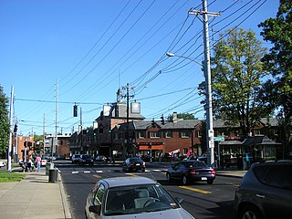
The Highlands is an area in Louisville, Kentucky which contains a high density of nightclubs, eclectic businesses, and many upscale and fast food restaurants. It is centered along a three-mile (5 km) stretch of Bardstown Road and Baxter Avenue and is so named because it sits atop a ridge between the middle and south forks of Beargrass Creek. The commercial area extends from the intersection of Bardstown Road and Taylorsville Road/Trevillian Way in the south, to the intersection of Baxter Avenue and Lexington Road in the north, a length of 3.2 miles (5.1 km). A 12-mile (800 m) section of the nearby Barret Avenue also contains many similar businesses. The residential area is separated from other adjacent areas like Germantown and Crescent Hill by the south and north forks of Beargrass Creek. The middle fork runs through Cherokee Park, and the south fork divides Germantown from Tyler Park, after flowing past several cemeteries and undeveloped forests downstream from Joe Creason Park. Due to its large collection of night clubs and restaurants, it is locally known as "Restaurant Row".

<span class="mw-page-title-main">Schuster Building</span> United States historic place

The Schuster Building is a mixed-use structure at the intersection of Bardstown Road and Eastern Parkway in the Highlands area of Louisville, Kentucky. Added to the National Register of Historic Places in 1980 as a "significant example" of Colonial Revival architecture as applied to commercial buildings, the Schuster building is one of Louisville's most prominent examples of that style.

<span class="mw-page-title-main">Mid-City Mall</span> Shopping mall in Kentucky, United States

Mid City Mall is a shopping mall in Louisville, Kentucky's Highlands area. While called a mall, and containing an enclosed shopping area, it has features atypical of suburban American malls, such as a comedy club, bar, grocery store and public library. A 1994 article in Louisville's Courier-Journal newspaper argued that the mall could be considered the "crossroads" of Louisville, and described it as being "only part shopping center, because it is also community center, courthouse square and retirement-village rec room."

<span class="mw-page-title-main">Parkways of Louisville, Kentucky</span> United States historic place

The parkway system of Louisville, Kentucky, also known as the Olmsted Park System, was designed by the firm of preeminent 19th century landscape architect Frederick Law Olmsted. The 26-mile (42 km) system was built from the early 1890s through the 1930s, and initially owned by a state-level parks commission, which passed control to the city of Louisville in 1942.

Bardstown Road is a major road in Louisville, Kentucky. It is known as "Restaurant Row", which comes from Bardstown Road's many restaurants, bakeries, and cafes, such as: "SuperChefs ", "Ramsi's Cafe on the World ", "Mark's Feed Store ", "Kizito Cookies ", and "Louisville Joe's Coffee Company ". It carries U.S. Route 31E and U.S. Route 150, from the intersection of Baxter Avenue (US 31E) and Broadway (US 150), southeast through Jefferson and Bullitt counties; in Spencer and Nelson counties, the road is named Louisville Road; that road becomes 3rd Street in Bardstown, where US 31E and US 150 split at the intersection with U.S. Route 62.

<span class="mw-page-title-main">Cherokee Triangle, Louisville</span> United States historic place

The Cherokee Triangle is a historic neighborhood in Louisville, Kentucky, USA, known for its large homes displaying an eclectic mix of architectural styles. Its boundaries are Bardstown Road to the southwest, Cherokee Park and Eastern Parkway to the southeast, and Cave Hill Cemetery to the north, and is considered a part of a larger area of Louisville called The Highlands. It is named for nearby Cherokee Park, a 409 acres (1.7 km2) park designed by Frederick Law Olmsted, the designer of New York's Central Park.

<span class="mw-page-title-main">Kentucky Route 1703</span> State highway in Kentucky, United States

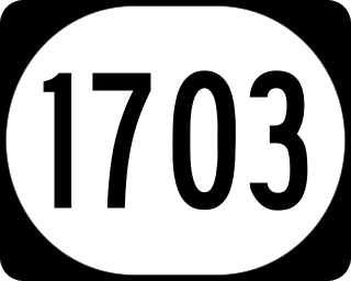
Kentucky Route 1703 is a north–south state highway extending 5.7 miles (9.2 km) across central Louisville, Kentucky. The southern terminus of the route is at Kentucky Route 2052. The northern terminus is at U.S. Route 31E/U.S. Route 150 at the junction of Bardstown Road, Baxter Avenue, and Highland Avenue. KY 1703 is named Newburg Road from KY 2052 to the Shady Lane intersection, where the road becomes Baxter Avenue for the duration of its route.

<span class="mw-page-title-main">Humphrey-McMeekin House</span> Historic house in Kentucky, United States

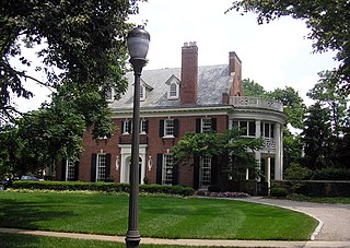
Humphrey-McMeekin House is considered one of the finest Colonial Revival houses in Louisville, Kentucky. It was designed and built in 1914–1915 as their private residence by newspaper editor Lewis Craig Humphrey (1875–1927) and his wife Eleanor Silliman Belknap Humphrey (1876–1964), both Louisville natives. The mansion was placed on the National Register of Historic Places in 1983.