Deer Park, Louisville

Last updated
Deer Park
Coordinates: 38°13′24″N85°42′21″W / 38.22340°N 85.70580°W / 38.22340; -85.70580
CountryUnited States
State Kentucky
City Louisville
Districts8
Government
  Council memberCassie Armstrong
ZIP code(s)
40205
Area code(s) 502
Website www.deerparklouisville.com

Deer Park is a neighborhood four miles southeast of downtown Louisville, Kentucky, USA. Most of the neighborhood was developed from 1890 through the 1920s as a streetcar suburb, with all but six of its 24 subdivisions being developed by 1917, and the last laid out by 1935, although some development west of Norris Place continued after World War II. [1]

Contents

Deer Park's boundaries are Bardstown Road, Newburg Road, Eastern Parkway and Douglass Boulevard. Deer Park is considered a part of a larger area of Louisville called The Highlands.

Historic Bullock Clifton house, built in 1834 Bullock clifton.jpg
Historic Bullock Clifton house, built in 1834

Prior to subdivision, it was agricultural. The origin of the name is not entirely clear, although recent campaigns to "put the deer back in Deer Park" have seen colorful deer sculptures placed at local businesses, parodying a Louisville-wide campaign with larger horse sculptures placed similarly. [2]

Schools and landmarks

The neighborhood is largely residential. Most businesses and other non-residential buildings are found along Norris Place, Bardstown Road, and Newburg Road. These facilities include Highland Middle School and the King's Daughters and Sons Home, an institute for the ill and disabled opened in 1909 and renamed Highlands Nursing Home in the early 2000s. Other schools in the neighborhood include the Catholic primary schools St. Francis and St. Agnes, and the DePaul School, a private school for students with dyslexia and other specific learning differences.

Bellarmine University is located on the Belknap side of the boundary between that neighborhood and Deer Park; until the 21st century, Deer Park residents had little contact with the university other than its function as a polling place during the elections. As the university has sought to expand its student base and campus, residents residing the closest to the university met with Bellarmine representatives on an ad hoc basis to address areas of concern such as street, rather than campus parking, and the building of a stadium in close proximity to houses on an adjoining street. The ad hoc nature of meeting with Bellarmine ceased in 2005 when there was a push by the university to buy houses on the Bellarmine side of Richmond Drive west of Norris and use them as student housing. This was opposed by Belknap and Deer Park residents and brought before the zoning commission. From this effort, the Good Neighbor Working Group was formed with Bellarmine to ensure their expansion and plans for growth did not adversely affect the integrity of the neighborhood.

A local landmark is the Bullock-Clifton House, also called the Yunker house, a former farmhouse built in 1834 and located at the corner of Richmond and Rosedale. The imposing structure was described in a 1980 study as "steamboat gothic," and is on the National Register of Historic Places. Early landowners included the Norris, Duker and Stevens families, after whom streets in the neighborhood are named. Two other streets are named after locations in Virginia (Richmond and Roanoke), and Hartman Avenue is named after developer George Hartman, who developed the area in 1914 on what was family property. [1]

Housing

A typical side-gabled bungalow in Louisville's Deer Park Neighborhood Bungalow.jpg
A typical side-gabled bungalow in Louisville's Deer Park Neighborhood

The area from Eastern Parkway to Speed Avenue and Fernwood to Bardstown Road is a National Register District, [3] and is also one of the most densely populated areas in Louisville. Since the mid-1970s, all of the somewhat narrow east–west streets here have been one-way, an oddity for a neighborhood relatively far from downtown.

Further contributing to the unusually high density for a neighborhood mostly of single family homes, Deer Park includes two pedestrian courts whose long rows of houses, with no conventional street, are accessible only by alleys and sidewalks running through the short front yards. Ivanhoe Court was built in 1914, and the slightly smaller Maplewood Place a year later in 1915. These types of developments, built during the streetcar suburb era, are apparently unique to Louisville. There are 11 in Old Louisville, but outside of Deer Park only a few others remain today. [4]

The neighborhood has long had more of a middle and working class reputation than surrounding Highlands neighborhoods, which range in character from upper-middle to outright upper class. The reason for this is primarily that Deer Park's housing stock is, other than the Yunker House, decidedly low-key. Due to the lack of geographical obstacles such as steep hills or creeks, the entire neighborhood was developed in a rather uniform and quick manner. Shotgun houses and 2½ story Victorians, more modest than those on the east side of Bardstown Road, make up the majority of the stock in the oldest sections, while modest craftsmen-style houses dominate streets further out, and a few small ranch style homes can be found west of Norris Place. In the north end near Douglass Boulevard is Forest Park, the last of the pre-World War II subdivisions, and the largest of any single development in Deer Park. Larger houses can be found here, many in various historical revival styles. [1]

Demographics

As of 2000, the population of Deer Park was 4,082, [5] of which 93.7% are white, 3.6% are listed as other, 2% are black, and 0.7% are Hispanic. College graduates are 48.3% of the population, people without a high school degree are 8%. Females outnumber males 51.8% to 48.2%.

Related Research Articles

<span class="mw-page-title-main">Tyler Park, Louisville</span>

Tyler Park is a neighborhood three miles (5 km) southeast of downtown Louisville, Kentucky, USA. It is considered a part of a larger area of Louisville called The Highlands. Near the middle of the neighborhood is a city park of the same name, and many houses in the neighborhood feature park views. The neighborhood boundaries are St Louis Cemetery to the north, Bardstown Road to the east, Eastern Parkway to the south and Beargrass Creek to the west.

<span class="mw-page-title-main">Original Highlands, Louisville</span> United States historic place

The Original Highlands is a historic neighborhood in the Highlands area of Louisville, Kentucky, United States.

<span class="mw-page-title-main">Bonnycastle, Louisville</span> Neighborhood in Louisville, Kentucky

Bonnycastle is a neighborhood four miles (6 km) southeast of downtown Louisville, Kentucky USA. It is considered a part of a larger area of Louisville called The Highlands. Its boundaries are Bardstown Road, Cherokee Road, Eastern Parkway and Speed Avenue.

Highlands–Douglass is a neighborhood five miles (8 km) southeast of downtown Louisville, Kentucky, United States. The neighborhood is bound by Bardstown Road, Speed Avenue, Taylorsville Road, and Cherokee Park. It is considered a part of a larger area of Louisville called The Highlands. It is often simply called Douglass.

<span class="mw-page-title-main">Neighborhoods in Louisville, Kentucky</span>

This is a list of official neighborhoods in Louisville, Kentucky. Like many older American cities, Louisville has well-defined neighborhoods, many with well over a century of history as a neighborhood.

Hayfield-Dundee is a neighborhood in eastern Louisville, Kentucky. Its boundaries are Dundee Road, Emerson Avenue, Newburg Road, I-264, and Tremont Drive to the east. Prior to subdivision, much of the land had been part of the Hayfield Farm, owned by Dr. Charles Wilkens Short, a founding professor of the University of Louisville medical school.

Gardiner Lane is a neighborhood in eastern Louisville, Kentucky, United States. Its boundaries are Emerson Avenue to the north, Bardstown Road to the east, I-264 to the south, and Tremont Drive to the west. As with surrounding neighborhoods, it was farmland well into the first half of the 1900s. 16 subdivisions were developed from 1913 to 1950.

Poplar Level is a neighborhood five miles (8 km) southeast of downtown Louisville, Kentucky, United States. It is part of the larger Camp Zachary Taylor area.

Bashford Manor is a neighborhood in Louisville, Kentucky, United States. Its boundaries are I-264 to the north, Bardstown Road to the east, Bashford Manor Lane to the south, and Newburg Road to the west. Originally a part of Thomas Byrd's 1,000 acre (4 km2) land grant from Virginia in 1787, James Bennett Wilder bought the land in 1870 and built a home which he named Bashford Manor, after his family's home in England. He sold the property to George James Long in 1888, who turned it into a horse farm which produced three early Kentucky Derby winners: Azra, Manuel and Sir Huon.

<span class="mw-page-title-main">Bullock-Clifton House</span> Historic house in Kentucky, United States

The Bullock-Clifton House is a historic home in the Deer Park neighborhood of Louisville, Kentucky, United States. It is the oldest known surviving wood-frame structure in Jefferson County. It was listed on the National Register of Historic Places in 1982.

<span class="mw-page-title-main">The Highlands, Louisville</span>

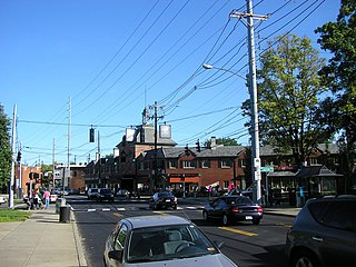
The Highlands is an area in Louisville, Kentucky which contains a high density of nightclubs, eclectic businesses, and many upscale and fast food restaurants. It is centered along a three-mile (5 km) stretch of Bardstown Road and Baxter Avenue and is so named because it sits atop a ridge between the middle and south forks of Beargrass Creek. The commercial area extends from the intersection of Bardstown Road and Taylorsville Road/Trevillian Way in the south, to the intersection of Baxter Avenue and Lexington Road in the north, a length of 3.2 miles (5.1 km). A 12-mile (800 m) section of the nearby Barret Avenue also contains many similar businesses. The residential area is separated from other adjacent areas like Germantown and Crescent Hill by the south and north forks of Beargrass Creek. The middle fork runs through Cherokee Park, and the south fork divides Germantown from Tyler Park, after flowing past several cemeteries and undeveloped forests downstream from Joe Creason Park. Due to its large collection of night clubs and restaurants, it is locally known as "Restaurant Row".

<span class="mw-page-title-main">Schuster Building</span> United States historic place

The Schuster Building is a mixed-use structure at the intersection of Bardstown Road and Eastern Parkway in the Highlands area of Louisville, Kentucky. Added to the National Register of Historic Places in 1980 as a "significant example" of Colonial Revival architecture as applied to commercial buildings, the Schuster building is one of Louisville's most prominent examples of that style.

Rose Hill is an antebellum house in Louisville, Kentucky. It was added to the National Register of Historic Places in 1980.

Bardstown Road is a major road in Louisville, Kentucky. It is known as "Restaurant Row", which comes from Bardstown Road's many restaurants, bakeries, and cafes, such as: "SuperChefs ", "Ramsi's Cafe on the World ", "Mark's Feed Store ", "Kizito Cookies ", and "Louisville Joe's Coffee Company ". It carries U.S. Route 31E and U.S. Route 150, from the intersection of Baxter Avenue (US 31E) and Broadway (US 150), southeast through Jefferson and Bullitt counties; in Spencer and Nelson counties, the road is named Louisville Road; that road becomes 3rd Street in Bardstown, where US 31E and US 150 split at the intersection with U.S. Route 62.

<span class="mw-page-title-main">Cherokee Triangle, Louisville</span> United States historic place

The Cherokee Triangle is a historic neighborhood in Louisville, Kentucky, USA, known for its large homes displaying an eclectic mix of architectural styles. Its boundaries are Bardstown Road to the southwest, Cherokee Park and Eastern Parkway to the southeast, and Cave Hill Cemetery to the north, and is considered a part of a larger area of Louisville called The Highlands. It is named for nearby Cherokee Park, a 409 acres (1.7 km2) park designed by Frederick Law Olmsted, the designer of New York's Central Park.

This is a list of properties and historic districts on the National Register of Historic Places in The Highlands, Louisville, Kentucky. The table below includes 32 listings in the following neighborhoods:

<span class="mw-page-title-main">Kentucky Route 1703</span> State highway in Kentucky, United States

Kentucky Route 1703 is a north–south state highway extending 5.7 miles (9.2 km) across central Louisville, Kentucky. The southern terminus of the route is at Kentucky Route 2052. The northern terminus is at U.S. Route 31E/U.S. Route 150 at the junction of Bardstown Road, Baxter Avenue, and Highland Avenue. KY 1703 is named Newburg Road from KY 2052 to the Shady Lane intersection, where the road becomes Baxter Avenue for the duration of its route.

Belknap is an urban neighborhood three and a half miles east of downtown Louisville, Kentucky, USA. The neighborhood is bound by Bardstown Road, Douglass Boulevard, Dundee Road and Newburg Road. It is part of a larger area of Louisville called the Highlands. Belknap is often described as the neighborhood in the heart of The Highlands.

References

  1. 1 2 3 Louisville Survey: East Report. 1980.
  2. Cengel, Katya (2006-04-09). "Deer Park lives up to name". The Courier-Journal.
  3. "About Deer Park Neighborhood". Archived from the original on 2005-04-15. Retrieved 2006-07-10.
  4. Yater, George H. (1986). "Court Society". Louisville: 21–22.
  5. "Community Resource Network" . Retrieved 2005-11-18.[ dead link ]