Bardstown Road

Last updated
Bardstown Road
Length55 mi (89 km)[ citation needed ]
South endUS 31E.svgUS 62.svgUS 150.svg US 31E  / US 62  / US 150 in Bardstown
Major
junctions
I-265.svg I-265 in Louisville
I-264.svg I-264 in Louisville
Alternate plate.svg
US 60.svg
US 60 Alt. in Louisville
North endUS 31E.svgUS 150.svg US 31E  / US 150 in Louisville

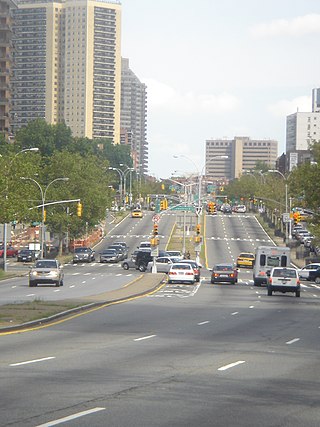
Bardstown Road is a major road in Louisville, Kentucky. It is known as "Restaurant Row [1] ", which comes from Bardstown Road's many restaurants, bakeries, and cafes, such as: "SuperChefs [2] ", "Ramsi's Cafe on the World [3] ", "Mark's Feed Store [4] ", "Kizito Cookies [5] ", and "Louisville Joe's Coffee Company [6] ". It carries U.S. Route 31E and U.S. Route 150, from the intersection of Baxter Avenue (US 31E) and Broadway (US 150), southeast through Jefferson and Bullitt counties; in Spencer and Nelson counties, the road is named Louisville Road; that road becomes 3rd Street in Bardstown, where US 31E and US 150 split at the intersection with U.S. Route 62 (Stephen Foster Avenue).

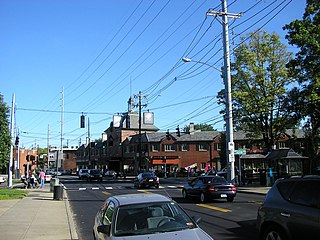
There is a segment in The Highlands from Douglass Boulevard to Bardstown Road's northern terminus at Baxter Avenue, along with several blocks of Baxter Avenue north of the terminus, that has four lanes, with the outer two lanes used for on-street parking during non-peak traffic hours. Parking is banned during morning and evening commuting hours, during which all four lanes become traffic lanes with movements controlled by lane lights. Two lanes are dedicated to traffic in the normal commuting direction (northbound in the morning and southbound in the evening); the lane to the left of commuting traffic becomes a dedicated left-turn lane; and the final lane accommodates traffic traveling opposite to the commuting direction. [7] Metro Councilman Brandon Coan (D-8) states that “Bardstown Road is one of the most dangerous roads in the state of Kentucky in terms of the number of crashes". [8]

In 2017, the merged government of Louisville and Jefferson County commissioned a study [9] to suggest possible changes to traffic patterns through The Highlands, with the study being released in mid-2018. The study recommended that the permanent traffic pattern should be one lane in each direction at all times, with permanent on-street parking throughout except at the approaches to signalized intersections, which would now include permanent left-turn lanes. Recommendations were also made for two more southerly sections of the road between Douglass Boulevard and the Watterson Expressway, which currently have two traffic lanes in each direction. The study also presents the idea that infrastructure for pedestrians is lacking and more crosswalks are needed. Between Douglass Boulevard and Taylorsville Road, on-street parking would be eliminated, and a center two-way left-turn lane would be added. Such a turn lane would also be added between Tyler Lane and Brighton Drive (roughly from Assumption High School to Sullivan University), an area without on-street parking. The final plan is set to be announced in August 2018, though because of the road's designation as a U.S. highway, state approval is required before any work can start. [7]

This study had now been completed and finalized modifications have been made public. These changes include, "one-lane in either direction with 24-hour parking on both sides, left turn lanes at intersections and updated stops for TARC buses [8] ". The KY transportation cabinet states that these changes will "increase pedestrian safety, decrease travel speeds and provide much needed parking in the area to support local businesses along the corridor [8] ". Metro Councilman Brandon Coan (D-8) told WAVE 3 the changes to Bardstown Road stem from a 2018 street safety study.

See also

Related Research Articles

<span class="mw-page-title-main">Michigan left</span> Type of intersection

A Michigan left or P-turn is an at-grade intersection design that replaces each left (farside) turn at an intersection between a (major) divided roadway and a secondary (minor) roadway with the combination of a right (nearside) turn followed by a U-turn, or a U-turn followed by a right (nearside) turn, depending on the situation. It is in use in numerous countries.

<span class="mw-page-title-main">U.S. Route 31</span> Highway in the United States

U.S. Route 31 or U.S. Highway 31 (US 31) is a major north–south U.S. highway connecting southern Alabama to northern Michigan. Its southern terminus is at an intersection with US 90/US 98 in Spanish Fort, Alabama. Its northern terminus is at an interchange with Interstate 75 (I-75) south of Mackinaw City, Michigan.

<span class="mw-page-title-main">U.S. Route 150</span> Highway in the Midwestern United States

U.S. Route 150 is a 571-mile (919 km) long northwest–southeast United States highway, signed as east–west. It runs from U.S. Route 6 outside of Moline, Illinois to U.S. Route 25 in Mount Vernon, Kentucky.

<span class="mw-page-title-main">Queens Boulevard</span> Boulevard in Queens, New York

Queens Boulevard is a major thoroughfare connecting Midtown Manhattan, via the Queensboro Bridge, to Jamaica in Queens, New York City, United States. It is 7.5 miles (12.1 km) long and forms part of New York State Route 25.

<span class="mw-page-title-main">Reversible lane</span> Lane in which traffic may travel in either direction

A reversible lane is a managed lane in which traffic may travel in either direction, depending on certain conditions. Typically, it is meant to improve traffic flow during rush hours, by having overhead traffic lights and lighted street signs notifying drivers which lanes are open or closed to driving or turning.

<span class="mw-page-title-main">Deer Park, Louisville</span> Louisville neighborhood in Kentucky, United States

Deer Park is a neighborhood four miles southeast of downtown Louisville, Kentucky, USA. Most of the neighborhood was developed from 1890 through the 1920s as a streetcar suburb, with all but six of its 24 subdivisions being developed by 1917, and the last laid out by 1935, although some development west of Norris Place continued after World War II.

<span class="mw-page-title-main">Tyler Park, Louisville</span>

Tyler Park is a neighborhood three miles (5 km) southeast of downtown Louisville, Kentucky, USA. It is considered a part of a larger area of Louisville called The Highlands. Near the middle of the neighborhood is a city park of the same name, and many houses in the neighborhood feature park views. The neighborhood boundaries are St Louis Cemetery to the north, Bardstown Road to the east, Eastern Parkway to the south and Beargrass Creek to the west.

<span class="mw-page-title-main">Original Highlands, Louisville</span> United States historic place

The Original Highlands is a historic neighborhood in the Highlands area of Louisville, Kentucky, United States.

Highlands–Douglass is a neighborhood five miles (8 km) southeast of downtown Louisville, Kentucky, United States. The neighborhood is bound by Bardstown Road, Speed Avenue, Taylorsville Road, and Cherokee Park. It is considered a part of a larger area of Louisville called The Highlands. It is often simply called Douglass.

<span class="mw-page-title-main">U.S. Route 31E</span> Highway in the United States

U.S. Route 31E (US 31E) is the eastern parallel route for U.S. Highway 31 from Nashville, Tennessee, to Louisville, Kentucky.

<span class="mw-page-title-main">The Highlands, Louisville</span>

The Highlands is an area in Louisville, Kentucky which contains a high density of nightclubs, eclectic businesses, and many upscale and fast food restaurants. It is centered along a three-mile (5 km) stretch of Bardstown Road and Baxter Avenue and is so named because it sits atop a ridge between the middle and south forks of Beargrass Creek. The commercial area extends from the intersection of Bardstown Road and Taylorsville Road/Trevillian Way in the south, to the intersection of Baxter Avenue and Lexington Road in the north, a length of 3.2 miles (5.1 km). A 12-mile (800 m) section of the nearby Barret Avenue also contains many similar businesses. The residential area is separated from other adjacent areas like Germantown and Crescent Hill by the south and north forks of Beargrass Creek. The middle fork runs through Cherokee Park, and the south fork divides Germantown from Tyler Park, after flowing past several cemeteries and undeveloped forests downstream from Joe Creason Park. Due to its large collection of night clubs and restaurants, it is locally known as "Restaurant Row".

<span class="mw-page-title-main">U.S. Route 1 in Maryland</span> Section of U.S. Route in Maryland, United States

U.S. Route 1 (US 1) is the easternmost and longest of the major north–south routes of the older 1920s era United States Numbered Highway System, running from Key West, Florida, to Fort Kent, Maine. In the U.S. state of Maryland, it runs 81 miles (130 km) from the Washington, D.C. line to the Pennsylvania state line near the town of Rising Sun.

<span class="mw-page-title-main">Schuster Building</span> United States historic place

The Schuster Building is a mixed-use structure at the intersection of Bardstown Road and Eastern Parkway in the Highlands area of Louisville, Kentucky. Added to the National Register of Historic Places in 1980 as a "significant example" of Colonial Revival architecture as applied to commercial buildings, the Schuster building is one of Louisville's most prominent examples of that style.

<span class="mw-page-title-main">Mid-City Mall</span> Shopping mall in Kentucky, United States

Mid City Mall is a shopping mall in Louisville, Kentucky's Highlands area. While called a mall, and containing an enclosed shopping area, it has features atypical of suburban American malls, such as a comedy club, bar, grocery store and public library. A 1994 article in Louisville's Courier-Journal newspaper argued that the mall could be considered the "crossroads" of Louisville, and described it as being "only part shopping center, because it is also community center, courthouse square and retirement-village rec room."

<span class="mw-page-title-main">Parkways of Louisville, Kentucky</span> United States historic place

The parkway system of Louisville, Kentucky, also known as the Olmsted Park System, was designed by the firm of preeminent 19th century landscape architect Frederick Law Olmsted. The 26-mile (42 km) system was built from the early 1890s through the 1930s, and initially owned by a state-level parks commission, which passed control to the city of Louisville in 1942.

<span class="mw-page-title-main">U.S. Route 150 in Kentucky</span> Section of U.S. Numbered Highway in Kentucky, United States

U.S. Route 150 (US 150) in Kentucky is a 121.097-mile-long (194.887 km) east–west highway that runs from the Indiana state line above the Ohio River to US 25/KY 1249 at Mount Vernon.

<span class="mw-page-title-main">Kentucky Route 1703</span> State highway in Kentucky, United States

Kentucky Route 1703 is a north–south state highway extending 5.7 miles (9.2 km) across central Louisville, Kentucky. The southern terminus of the route is at Kentucky Route 2052. The northern terminus is at U.S. Route 31E/U.S. Route 150 at the junction of Bardstown Road, Baxter Avenue, and Highland Avenue. KY 1703 is named Newburg Road from KY 2052 to the Shady Lane intersection, where the road becomes Baxter Avenue for the duration of its route.

<span class="mw-page-title-main">Kentucky Route 2860</span> State highway in Kentucky, United States

Kentucky Route 2860 is a state highway in the city of Louisville in Kentucky. The highway runs 0.981 miles (1.579 km) along Grinstead Drive from U.S. Route 31E and US 150 east to US 60 Alt. KY 2860 was established in 1984.

Belknap is an urban neighborhood three and a half miles east of downtown Louisville, Kentucky, USA. The neighborhood is bound by Bardstown Road, Douglass Boulevard, Dundee Road and Newburg Road. It is part of a larger area of Louisville called the Highlands. Belknap is often described as the neighborhood in the heart of The Highlands.

<span class="mw-page-title-main">Kentucky Route 864</span> State highway in Kentucky, United States

Kentucky Route 864 is a 16.339-mile-long (26.295 km) state highway located entirely in the Louisville metropolitan area of Jefferson County in north central Kentucky.

References

  1. "The Highlands in Louisville KY : GoToLouisville.com Official Travel Source". www.gotolouisville.com. Retrieved 2021-12-13.
  2. "SuperChefs : GoToLouisville.com Official Travel Source".
  3. "Ramsi's Cafe Source".
  4. "Mark's Feed Store Source".
  5. "Kizito Cookies Source".
  6. "Louisville Joe's Coffee Company Source".
  7. 1 2 Bailey, Phillip M. (June 7, 2018). "Louisville looks at killing rush hour lanes on Bardstown Road". The Courier-Journal . Retrieved July 10, 2018.
  8. 1 2 3 Goin, Stephen. "Bardstown Road 'reconfigured' to increase safety, support Highlands businesses". www.wave3.com. Retrieved 2021-12-13.
  9. Andreina Centlivre. "Bardstown Road safety study complete, but don't expect improvements soon". www.wave3.com. Retrieved 2021-12-13.