Abaokoro | |
|---|---|
| Country | Kiribati |

Abaokoro is a settlement in Kiribati. It is located about nine nautical miles from Tarawa. It is located in the Tarawa Atoll.
Abaokoro Post Office opened on 13 December 1956. [1]
Abaokoro | |
|---|---|
| Country | Kiribati |
Abaokoro is a settlement in Kiribati. It is located about nine nautical miles from Tarawa. It is located in the Tarawa Atoll.
Abaokoro Post Office opened on 13 December 1956. [1]
Tabiteuea is an atoll in the Gilbert Islands, Kiribati, farther south of Tarawa. This atoll is the second largest and the most populated of the Gilbert Islands after Tarawa. The atoll consists of one main island, Aanikai in the north, and several smaller islets in between along the eastern rim of the atoll. The atoll has a total land area of 38 km2 (15 sq mi), while the lagoon measures 365 km2 (141 sq mi). The population numbered 5,261 in 2015. The islanders have customary fishing practices related to the lagoon and the open ocean.

Tarawa is an atoll and the capital of the Republic of Kiribati, in the Micronesia region of the central Pacific Ocean. It comprises North Tarawa, which has 6,629 inhabitants and much in common with other more remote islands of the Gilbert group, and South Tarawa, which has 56,388 inhabitants as of 2015, half of the country's total population. The atoll was the site of the Battle of Tarawa during World War II.

Betio is the largest township of Kiribati's capital city, South Tarawa, and the country's main port. The settlement is located on a separate islet at the extreme southwest of the atoll.

Arorae is an atoll in Kiribati located near the equator. Arorae is the southernmost island in the Gilbert Islands group. It has a population of just over a thousand inhabitants on 9.5 square kilometres.

Abemama (Apamama) is an atoll, one of the Gilberts group in Kiribati, and is located 152 kilometres southeast of Tarawa and just north of the Equator. Abemama has an area of 27.37 square kilometres and a population of 3,299 as of 2015. The islets surround a deep lagoon. The eastern part of the atoll of Abemama is linked together by causeways making automobile traffic possible between the different islets. The outlying islands of Abatiku and Biike are situated on the southwestern side of the atoll.

Aranuka is an atoll of Kiribati, located just north of the equator, in the Gilbert Islands. It has an area of 11.6 square kilometres and a population of 1,057 in 2010. By local tradition, Aranuka is the central island of the Gilbert group.
Elsey is an unincorporated community in Stone County, Missouri, United States. It is located at the intersection of State Routes 173 and 413 and is halfway between Galena and Crane. The community is part of the Branson, Missouri Micropolitan Statistical Area.

Beru is an atoll in the Southern Gilbert Islands in the Pacific Ocean, part of the Republic of Kiribati. Beru was previously known as Eliza, Francis Island, Maria, Peroat, Peru Island or Sunday. It's part of a larger reef with the Nuka Lagoon at its center, and the nearest island is Nikunau. The Tabiang Lagoon is present in the north. Beru is home to 2,051 inhabitants. Due to sea surges, the atoll is experiencing coastal erosion along with damages to seawalls.
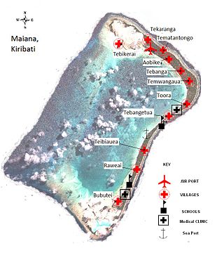
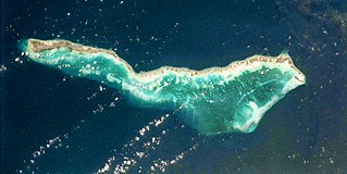
Maiana is an atoll in Kiribati and is one of the Central Gilbert Islands. Maiana is 44 kilometres (27 mi) south of the capital island of South Tarawa and has a population of 1,982 as of 2015. The northern and eastern sides of the atoll are a single island, whilst the western edge consists of submerged reefs and many uninhabited islets, all surrounding a lagoon. The atoll is 14 kilometres (8.7 mi) long and is very narrow, with an average width of less than 1 kilometre (0.62 mi) and a total land area of 16.72 square kilometres (6.46 sq mi).

Nonouti is an atoll and district of Kiribati. The atoll is located in the Southern Gilbert Islands, 38 km north of Tabiteuea, and 250 km south of Tarawa. The atoll is the third largest in the Gilbert Islands and is the island where the Roman Catholic religion was first established in Kiribati, in 1888.

Onotoa is an atoll of Kiribati. It is situated in the Gilbert Islands in the Pacific Ocean, 65 km (40 mi) from Tamana, the smallest island in the Gilberts. The population of Onotoa in the 2015 census was 1,393.

Makin is the name of an atoll, chain of islands, located in the Pacific Ocean island nation of Kiribati. Makin is the northernmost of the Gilbert Islands, with a population of 1,990.
Bikenibeu is a settlement in Kiribati. It is located close to the southeastern corner of the Tarawa atoll, part of the island country of Kiribati. It is part of a nearly continuous chain of settlements along the islands of South Tarawa, which are now linked by causeways. The low-lying atoll is vulnerable to sea level rise. Rapid population growth has caused some environmental problems. Kiribati's main government high school, King George V and Elaine Bernachi School, is located in Bikenibeu, as well as the Ministries of Environment and Education.

Biketawa is one of the twenty-four small islets which comprise the atoll of Tarawa in the Republic of Kiribati. The capital of Kiribati, South Tarawa, is located on Tarawa.
Bonriki is a settlement on Tarawa atoll, Kiribati, near Temwaiku and is part of the municipality of South Tarawa. It is in the south-east of South Tarawa. Bonriki International Airport, one of two international airports in Kiribati, is located here. One of the first roads linking islands together in Tarawa connects Bonriki to Bikenibeu.
Kinnabulla is a locality located in the local government area of the Shire of Buloke, Victoria, Australia. The population of the locality is 173 people, 91 being male, and 82 being female. Kinnabulla Railway Station was a station on the Mildura railway line. The station closed to passenger and parcels traffic on 11 November 1975. The post office there opened in 1902 and was closed on 11 November 1973.

The Sacred Heart Cathedral is a religious building of the Catholic church that is located in South Tarawa on the atoll of Tarawa part of the island nation of Kiribati in Oceania.
King George V and Elaine Bernacchi School (KGV/EBS) is a government senior high school of Kiribati, located in Bikenibeu, South Tarawa. As of 1993 it had almost 600 students. In 1993 it had a competitive admissions process as there was not enough space for every high school student in Kiribati; the remainder had to enroll in Christian high schools. Since then the Kiribati government has established two additional government high schools.
King George V School (KGV) was a government high school for boys in the Gilbert Islands, within the British colony Gilbert and Ellice Islands. Throughout its history it was in multiple locations in South Tarawa and Abemama. It served as a boarding school, and trained people to be government workers and teachers.

Teaoraereke is a town and settlement in South Tarawa of Kiribati.
1°29′26″N173°01′32″E / 1.490625°N 173.025570°E
| | This Kiribati location article is a stub. You can help Wikipedia by expanding it. |