Buton

Last updated
Buton
Sulawesi location map plain.svg
Red pog.svg
Buton
Geography
Location Southeast Asia
Coordinates 5°3′S122°53′E / 5.050°S 122.883°E / -5.050; 122.883
Area4,727.07 km2 (1,825.13 sq mi)
Highest elevation1,100 m (3600 ft)
Highest pointUnnamed
Administration
ProvinceFlag of Southeast Sulawesi.svg  Southeast Sulawesi
Largest settlement Baubau (pop. 159,248)
Demographics
Population414,899 (2020 Census)
Pop. density87.8/km2 (227.4/sq mi)
Ethnic groups Butonese people
Additional information
Time zone
Buton and surrounding islands Buton Topography.png
Buton and surrounding islands

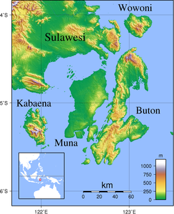
Buton (also Butung, Boeton or Button) is an island in Indonesia located off the southeast peninsula of Sulawesi. It covers roughly 4,727 square kilometers in area, or about the size of Madura; it is the 129th largest island in the world and Indonesia's 19th largest in area.

Contents

History

First minister of Buton COLLECTIE TROPENMUSEUM Eerste minister van Buton Zuid-Celebes TMnr 10001614.jpg
First minister of Buton

In the precolonial era, the island, then usually known as Butung, was within the sphere of influence of Ternate. Especially in the sixteenth century, Buton served as an important secondary regional center within the Ternaten empire, controlling regional trade and collecting tribute to be sent to Ternate.

The Sultanate of Buton ruled over the island from the 14th until the 20th century. [1]

Sultan Murhum, the first Islamic monarch on the island, is remembered in the name of the island's major harbor, Murhum Harbor, in Baubau.

Geography

Its largest town is Baubau, where the Wolio and Cia-Cia languages are spoken. Major nearby islands include Wawonii (to the north), Muna and Kabaena (to the west) and Siumpu (to the southwest). The Tukangbesi Islands lie just to the east where Tukang Besi is spoken, and is separated by the Gulf of Kolowana Watabo (Teluk Kolowana Watabo).

Batuatas Island is to the south. Also the Bouton Passage (as it was known in the pre-Independence era) was an important inter-island navigational location of the northern Flores Sea. [2]

Ecology

The island is largely covered by rainforest and is known for its wildlife. It is one of only two habitats of the anoa, a type of buffalo.

People

Portrait of a delegation from Buton COLLECTIE TROPENMUSEUM Portret van een gezantschap van Buton Sulawesi TMnr 10020641.jpg
Portrait of a delegation from Buton

The languages spoken on Buton include Wolio, Cia-Cia, various dialects of Muna, Tukang Besi, Kumbewaha, Lasalimu, Kamaru, Pancana, Busoa, Taloki, Kulisusu and Kioko. [3] [4] The Indonesian language, the national language of Indonesia, is also widely used and taught in schools.

In 2009, the Cia-Cia tribe in Baubau city began to use the Korean Hangul alphabet for their language, based on textbooks created by the Hunminjeongeum Society, a linguistic society in Seoul. [5] , but in 2012 it was reported that adoption ultimately failed and has been abandoned. [6]

Economy

The island has a massive reserve of natural asphalt and several other minerals. Asphalt from Buton can be utilized as bitumen modifiers [7] as well as a substitute for petroleum asphalt. As a result, natural asphalt can be used to reduce dependency on conventional fossil based resources.

Administration

Buton Island is administratively divided into five second level administrative divisions (Daerah Tingkat II): Baubau City, Buton Regency, (part of) South Buton Regency (which includes several smaller islands to the west and south of Buton), North Buton Regency and (part of) Muna Regency.

KabupatenArea
in
km2
Pop'n
Census
2010 [8]
Pop'n
Census
2020 [9]
comprising
North Buton Regency1,923.0354,73666,653all districts
Muna Regency (part)400.7819,48822,534Pasih Putih, Pasi Kolaga, Wakorumba Selatan, Batukara and Maligano districts
Buton Regency1,648.0494,388115,207all districts
Baubau city295.07136,991159,248all districts
South Buton Regency (part)460.1541,88651,257Sampolawa, Lapandewa and Batauga districts
Totals4,727.07347,489414,899

However, the eponymous archipelago is administered under an additional four regencies: the rest of Muna Regency and South Buton Regency, together with West Muna Regency, Wakatobi Regency, Central Buton Regency (which does not include any portion of Buton Island), and (part of) Bombana Regency.

Notes

  1. Purwanto, Muhammad Roy (October 2017). "SISTEM PEMERINTAHAN ISLAM DAN UNDANG-UNDANG KESULTANAN BUTON DI SULAWESI TENGGARA". Kecamatan Galang Dalam Angka. ISSN   0852-7504.
  2. Goodall, George (Editor)(1943) Philips' International Atlas London, George Philip and Son map 'East Indies' pp.91-92
  3. van den Berg, Rene (1991). "Preliminary Notes on the Cia-Cia language (South Buton)". Excursies in Celebes. p. 305. ISBN   90-6718-032-7.
  4. "Ethnologue" . Retrieved 2009-10-11.
  5. "Cia-Cia adopts Hangul to preserve spoken language". 7 August 2009.
  6. "Adoption of Hangeul by Indonesian Tribe Hits Snag", The chosunibo
  7. "Buton Asphalt Indonesia".
  8. Biro Pusat Statistik, Jakarta, 2011.
  9. Badan Pusat Statistik, Jakarta, 2021.

Related Research Articles

<span class="mw-page-title-main">Provinces of Indonesia</span> The first-level subdivision of Indonesia

Provinces of Indonesia are the 38 administrative divisions of Indonesia and the highest tier of the local government. Provinces are further divided into regencies and cities, which are in turn subdivided into districts (kecamatan).

<span class="mw-page-title-main">Southeast Sulawesi</span> Province of Indonesia

Southeast Sulawesi is a province on the island of Sulawesi, forming the southeastern peninsula of that island, together with a number of substantial offshore islands such as Buton, Muna, Kabaena and Wawonii, together with many smaller islands. The capital is the city of Kendari, on the east coast of the peninsula.

<span class="mw-page-title-main">Morotai Island Regency</span> Regency in North Maluku, Indonesia

Morotai Island Regency is a regency of North Maluku province, Indonesia, located on Morotai Island. It covers an area of 2,336.6 km2 including the smaller Rao Island to the west of Morotai. The population was 52,860 at the 2010 census and 74,436 at the 2020 census; the official estimate as at mid 2022 was 78,270.

<span class="mw-page-title-main">Maluku (province)</span> Province of Indonesia

Maluku is a province of Indonesia. It comprises the central and southern regions of the Maluku Islands. The main city and capital of Maluku province is Ambon on the small Ambon Island. The land area is 46,150.92 km2, and the total population of this province at the 2010 census was 1,533,506 people, rising to 1,848,923 at the 2020 census. The official estimate as at mid 2022 was 1,881,727. Maluku is located in Eastern Indonesia. It is directly adjacent to North Maluku, Southwest Papua, and West Papua in the north, Central Sulawesi, and Southeast Sulawesi in the west, Banda Sea, East Timor and East Nusa Tenggara in the south and Arafura Sea, Central Papua and South Papua in the east.

<span class="mw-page-title-main">Obi Islands</span> Group of islands in North Maluku, Indonesia

The Obi Islands are a group of 42 islands in the Indonesian province of North Maluku, north of Buru and Ceram, and south of Halmahera. With a total area of 3,048.08 km2, they had a population of 41,455 at the 2010 Census and 50,760 at the 2020 Census. The official estimate as at mid 2022 was 52,588.

<span class="mw-page-title-main">Muna Island</span> Island in Southeast Sulawesi, Indonesia

Muna is an island in the Southeast Sulawesi province of Indonesia with an area of 3,219.84 km2 (1,243.19 sq mi) and had a population of 316,293 at the 2010 Census and 368,654 at the 2020 Census. It is just southeast of the island of Sulawesi and west of Buton Island. It currently comprises most of three administrative regencies within the province: Muna Regency, West Muna Regency, and Central Buton Regency.

<span class="mw-page-title-main">Baubau</span> City in Southeast Sulawesi, Indonesia

Baubau is a city in Southeast Sulawesi province, Indonesia. The city is located on the southwest coast of Buton island. Baubau attained city status on 21 June 2001, based on Indonesian Law Number 13, for the year 2001. It covers an area of 294.98 km2, including about 30 km2 of water area, and had a population of 136,991 at the 2010 Census and 159,248 at the 2020 Census; the official estimate as at mid 2021 was 161,354.

The Muna–Buton languages are a group of languages spoken on the islands of Muna and Buton off the coast of South East Sulawesi province, Indonesia. They belong to the Celebic subgroup of the Austronesian family.

<span class="mw-page-title-main">Languages of Sulawesi</span> Languages of a geographic region

On the Indonesian island of Sulawesi, 114 native languages are spoken, all of which belong to the Malayo-Polynesian subgroup of the Austronesian language family. With a total number of 17,200,000 inhabitants, Sulawesi displays a high linguistic diversity when compared with the most densely populated Indonesian island Java, which hosts 4–8 languages spoken by 145,100,000 inhabitants.

Cia-Cia, also known as Buton or Butonese, is an Austronesian language spoken principally around the city of Baubau on the southern tip of Buton island, off the southeast coast of Sulawesi, in Indonesia.

<span class="mw-page-title-main">Sitaro Islands Regency</span> Regency in North Sulawesi, Indonesia

Sitaro Islands Regency is a regency located off the northern extremity of Sulawesi Island in the southern Sangihe Islands, North Sulawesi Province, Indonesia. The regency was formed under Law Number 15 Year 2007 from 2 January 2007, by separation from the Sangihe Islands Regency of which it had previously formed the southern part. The short form of the name is formed from the those of the three principal islands — Siau, Tagulandang and Biaro.

<span class="mw-page-title-main">Buton Regency</span> Regency in Southeast Sulawesi, Indonesia

Buton Regency is a regency of Indonesia's Southeast Sulawesi Province, lying entirely on Buton Island. Until 2014 it had an area of 2,681.22 km2, and a population estimated at 276,944. However, in 2014 it was divided into three regencies, with two new regencies being cut out of it; the residual area now is 1,648.04 km2, and the districts in that area contained a population of 94,388 at the 2010 Census while the 2020 Census produced a total of 115,207; the official estimate as at mid 2021 was 117,040.

<span class="mw-page-title-main">Muna Regency</span> Regency in Southeast Sulawesi, Indonesia

Muna Regency is a regency of Southeast Sulawesi Province of Indonesia, covering parts of the island of Muna as well as part of the neighbouring Buton Island and smaller islands off its coast. Until 2014 it had an area of 2,945.05 km2, but in that year the western eleven districts of that Regency were split off to form a new West Muna Regency. The reduced regency now covers an area of 2,057.69 km2, and the districts comprising that area had a population of 196,645 at the 2010 Census; the total at the 2020 Census was 215,527, and the official estimate as at mid 2021 was 218,956, comprising 107,439 males and 111,517 females. The principal town lies at Raha, in Katobu District.

<span class="mw-page-title-main">North Buton Regency</span> Regency in Southeast Sulawesi, Indonesia

North Buton Regency is a regency of Indonesia's Southeast Sulawesi Province, which was separated from Buton Regency in accordance with Indonesia's Law Number 14 of 2007. The area of the regency, which covers the north part of Buton Island, is 1,923.03 km2. Its population was 54,736 at the 2010 Census and 66,653 at the 2020 Census; the official estimate as at mid 2021 was 67,714. The principal town lies at Buranga.

<span class="mw-page-title-main">Buri Wolio</span> Modified Arabic script for Wolio writing

Buri Wolio is an Arabic/Jawi script modified to write Wolio, a language spoken in and around Baubau, the capital of Buton, Southeast Sulawesi, Indonesia. Generally, this script is same with Jawi script, except in Buri Wolio, vowel sounds are symbolized. This script has 35 letters, 28 letters from Arabic alphabet and 7 additional letters similar to those in Jawi script to represent sounds not found in Arabic. Of these, 22 are used for writing of Wolio language, while 13 are reserved for writing loanwords of Arabic origin.

<span class="mw-page-title-main">Butonese people</span> Ethnic group of Indonesia

The Butonese people is a collective term that embraces a number of ethnic groups of Buton and neighbouring islands in Southeast Sulawesi. Like many other ethnic groups in Sulawesi, the Butonese are seafarers and traders. Butonese have long since migrated to many parts of the Malay archipelago using smaller vessels ranging from those that can only accommodate five people to large boats that can hold up to about 150 tons of goods. In general, the Butonese are a community that inhabits the region of the historical Buton Sultanate. When the swapraja domain was abolished, so did the Buton Sultanate which ended in 1951. The area of the former Sultanate is now distributed over several regencies and cities of Southeast Sulawesi. Among them are Baubau, Buton Regency, South Buton Regency, Central Buton Regency, North Buton Regency, Wakatobi Regency and Bombana Regency.

<span class="mw-page-title-main">West Muna Regency</span> Regency in Sulawesi, Indonesia

West Muna Regency is a new regency of Southeast Sulawesi, Indonesia, established under Act No.14 of 2014, dated 23 July 2014 by separation from the Muna Regency. It covers an area of 906.28 km2, and the districts comprising it had a population of 71,632 at the 2010 Census; the 2020 Census resulted in a population of 84,590, and the official estimate as at mid 2021 was 84,777, comprising 41,888 males and 42,889 females.The administrative centre lies at Laworo.

<span class="mw-page-title-main">Central Buton Regency</span> Regency in Sulawesi, Indonesia

Central Buton Regency is a new regency of Southeast Sulawesi established by separation from Buton Regency under Act No.15 of 2014, dated 23 July 2014. It covers an area of 837.08 km2 comprising the southern parts of Muna Island and Kabaena Island, together with several small offshore islands adjacent to the two main islands, with no territory located on Buton Island. It had a population of 86,112 at the 2010 Census and 114,773 at the 2020 Census; the official estimate as at mid 2021 was 116,599. The administrative centre lies at Labungkari.

<span class="mw-page-title-main">South Buton Regency</span> Regency in Sulawesi, Indonesia

South Buton Regency is a regency located in Southeast Sulawesi. This regency was formed from the southern part of Buton Regency, from which it was separated by Act No.16 of 2014, dated 23 July 2014. It covers an area of 546.58 km2, and the population of the districts now comprising the new regency was 74,974 at the 2010 Census and 95,261 at the 2020 Census; the official estimate as at mid 2021 was 95,472. The regency capital is located in Batauga.

The Sultanate of Buton was an indigenous sultanate in what is today Indonesia. It used to rule over Buton island and adjacent areas within present-day Southeast Sulawesi province. It was a constitutional monarchy with its own written constitution and law, complete with bodies acting as a legislature, a system of judiciary, and executive power.