
The Antarctic is a polar region around Earth's South Pole, opposite the Arctic region around the North Pole.

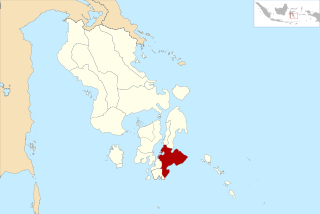
Southeast Sulawesi, is a province on the island of Sulawesi, forming the southeastern peninsula of that island, together with a number of substantial offshore islands such as Buton, Muna, Kabaena and Wawonii, together with many smaller islands. It is bordered by South Sulawesi and Central Sulawesi to the north, sharing a maritime border with Maluku and North Maluku to the east and East Nusa Tenggara to the south, as well a very narrow maritime border with East Timor to the south. The capital is the city of Kendari, on the east coast of the peninsula.

The Amundsen Sea is an arm of the Southern Ocean off Marie Byrd Land in western Antarctica. It lies between Cape Flying Fish to the east and Cape Dart on Siple Island to the west. Cape Flying Fish marks the boundary between the Amundsen Sea and the Bellingshausen Sea. West of Cape Dart there is no named marginal sea of the Southern Ocean between the Amundsen and Ross Seas. The Norwegian expedition of 1928–1929 under Captain Nils Larsen named the body of water for the Norwegian polar explorer Roald Amundsen while exploring this area in February 1929.
Serang Regency is a regency of Banten province, Indonesia. It is located in the northwest corner of the island of Java. The administrative center of the regency is at Ciruas, while the capital of the province is the independent municipality of Serang which was split off the regency on 17 July 2007.
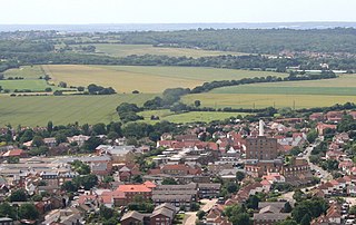
Rochford is a local government district in Essex, England. It is named after one of its main settlements, Rochford, where the council is based. The largest town in the district is Rayleigh. Other places in the district include Hockley, Ashingdon, Great Wakering, Canewdon and Hullbridge.

Rote Island is an island of Indonesia, part of the East Nusa Tenggara province of the Lesser Sunda Islands. According to legend, this island got its name accidentally when a lost Portuguese sailor arrived and asked a farmer where he was. The surprised farmer, who could not speak Portuguese, introduced himself, "Rote".

The Molucca Sea is located in the western Pacific Ocean, around the vicinity of Indonesia, specifically bordered by the Indonesian Islands of Celebes (Sulawesi) to the west, Halmahera to the east, and the Sula Islands to the south. The Molucca Sea has a total surface area of 77,000 square miles. The Molucca Sea is rich in coral and has many diving sites due to the deepness of its waters. The deepness of the water explains the reasoning behind dividing the sea into three zones, which functions to transport water from the Pacific Ocean to the shallower seas surrounding it. The deepest hollow in the Molucca Sea is the 15,780-foot (4,810-meter) Batjan basin. This region is known for its periodic experiences of earthquakes, which stems from the sea itself being a micro plate, in which the Molucca Sea is being subducted in two opposite directions: one in the direction of the Eurasian Plate to the west and the other in the direction of the Philippine Sea Plate to the east.

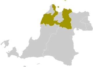
Wakatobi Regency is a group of ca. 150 islands forming an administrative regency located in Southeast Sulawesi Province of Indonesia. The four largest islands are Wangi-wangi, Kaledupa, Binongko and Tomia. The capital of the regency is located on Wangi-wangi Island, and was established by virtue of Law of the Republic of Indonesia Number 29 of 2003 dated 18 December 2003. The regency has an area of 473.62 square kilometres and had a population of 92,922 at the 2010 Census and 111,402 at the 2020 Census; the official estimate as at mid 2023 was 117,630.

Wangi Wangi is a suburb of the City of Lake Macquarie in New South Wales, Australia, which forms a peninsula jutting eastwards into Lake Macquarie. Wangi Wangi is a well known holiday spot, that was frequented in the early days by families from the coalfields. It is known for its views, bush-walking, and fishing spots.
Myuna Bay is a suburb of the City of Lake Macquarie in New South Wales, Australia, and is located west of Lake Macquarie near Wangi Wangi.

The grey-sided flowerpecker is a species of bird in the family Dicaeidae. It is endemic to Indonesia. Its natural habitats are subtropical or tropical moist lowland forest and subtropical or tropical moist montane forest.

The pale-bellied white-eye is a species of bird in the family Zosteropidae. It is endemic to SE Sulawesi in Indonesia. Its natural habitat is subtropical or tropical moist lowland forest. The species has a limited distribution and also appears to be sensitive to human disturbance.
Wangi wangi or Wangi-wangi may refer to:
Tukangbesi Islands, is a group of islands off the coast of Sulawesi immediately east of Buton island in the Banda Sea region, and part of Sulawesi Tenggara. "Tukang Besi" literally means "iron worker" or "blacksmith" in Indonesian. There is a Tukang Besi language. Separating Buton and the group is the Gulf of Kolowana Watabo.

Taka Bonerate National Park is a marine park which includes the Takabonerate atoll islands, located in the Flores Sea, south of Sulawesi island of Indonesia.
Wakatobi National Park is a marine national park in Southeast Sulawesi, Indonesia. The name of Wakatobi is a portmanteau of the four main Tukangbesi Islands: Wangi-wangi, Kaledupa, Tomia, and Binongko. Since 2005 the park is listed as a tentative World Heritage Site.

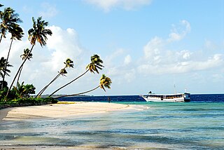
Matahora Airport is located in Wangi-wangi Island, Wakatobi Regency, Southeast Sulawesi, Indonesia. The airport serves as the point of entry to the Wakatobi National Park, a major international tourist destination, and the surrounding environs.
Buton Regency is a regency of Indonesia's Southeast Sulawesi Province, lying entirely on Buton Island. Until 2014 it had an area of 2,681.22 km2, and a population estimated at 276,944. However, in 2014 it was divided into three regencies, with two new regencies being cut out of it; the residual area now is 1,647.87 km2, and the districts in that area contained a population of 94,388 at the 2010 Census while the 2020 Census produced a total of 115,207; the official estimate as at mid 2023 was 120,873 The capital is nominally at Pasarwajo, but the regency's administration is actually undertaken in the city of Baubau on the south-west of the island, although that city is administratively separate from the Regency.

The Wakatobi flowerpecker is a subspecies of the grey-sided flowerpecker that is endemic to the Wakatobi Islands of Indonesia. Some authorities consider it to be a separate species as Dicaeum kuehni.

The Wangi-wangi white-eye or locally called as Sui, is a species of songbird in the white-eye family. Zosterops paruhbesar has a near full yellow body with the head, throat, vent and mid vental stripe. The flanks are slightly grey and the flight feathers and tail feathers are brown. Around the eye of Zosterops paruhbesar is a ring of white feathers.