
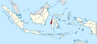
Southeast Sulawesi, is a province on the island of Sulawesi, forming the southeastern peninsula of that island, together with a number of substantial offshore islands such as Buton, Muna, Kabaena and Wawonii, together with many smaller islands. It is bordered by South Sulawesi and Central Sulawesi to the north, sharing a maritime border with Maluku and North Maluku to the east and East Nusa Tenggara to the south, as well a very narrow maritime border with East Timor to the south. The capital is the city of Kendari, on the east coast of the peninsula.
West Sulawesi is a province of Indonesia. It borders the provinces of South Sulawesi and Central Sulawesi to the east, Makassar Strait to the west, and the Pacific Ocean to the south. The province also shares maritime borders with East Kalimantan and South Kalimantan to the west and West Nusa Tenggara to the south. It is located on the western side of Sulawesi island. It covers an area of 16,594.75 km2, and its capital is the town of Mamuju. The 2010 Census recorded a population of 1,158,651, while that in 2020 recorded 1,419,228; the official estimate as at mid 2022 was 1,458,606.
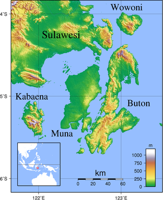
Buton is an island in Indonesia located off the southeast peninsula of Sulawesi. It covers roughly 4,727 square kilometers in area, or about the size of Madura; it is the 129th largest island in the world and Indonesia's 19th largest in area.
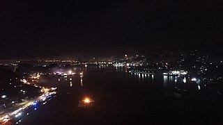
Kendari is the capital city of the Indonesian province of Southeast Sulawesi. It had a population of 289,966 at the 2010 Census and 345,107 at the 2020 census, making it the most populous city in the province, and the fourth most on Sulawesi. The official estimate as at mid 2022 was 356,747 - comprising 179,507 males and 177,240 females. The city covers an area of 270.18 square kilometers (104.32 sq mi), or about 0.7 percent of Southeast Sulawesi's land area. Located on Kendari Bay, it continues to be an important trade center, with the province's main port and airport. It is the economic and educational center of the province, home to various universities and colleges. Kendari has the highest Human Development Index (HDI) in Sulawesi.

Wakatobi Regency is a group of ca. 150 islands forming an administrative regency located in Southeast Sulawesi Province of Indonesia. The four largest islands are Wangi-wangi, Kaledupa, Binongko and Tomia. The capital of the regency is located on Wangi-wangi Island, and was established by virtue of Law of the Republic of Indonesia Number 29 of 2003 dated 18 December 2003. The regency has an area of 473.62 square kilometres and had a population of 92,922 at the 2010 Census and 111,402 at the 2020 Census; the official estimate as at mid 2022 was 115,286 - comprising 57,662 males and 57,624 females.
Muna is an island in the Southeast Sulawesi province of Indonesia with an area of 3,219.84 km2 (1,243.19 sq mi) and had a population of 316,293 at the 2010 Census and 368,654 at the 2020 Census. It is just southeast of the island of Sulawesi and west of Buton Island. It currently comprises most of three administrative regencies within the province: Muna Regency, West Muna Regency, and Central Buton Regency.

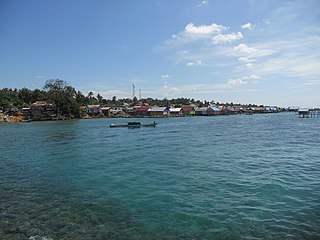
Baubau is a city in Southeast Sulawesi province, Indonesia. The city is located on the southwest coast of Buton island. Baubau attained city status on 21 June 2001, based on Indonesian Law Number 13, for the year 2001. It covers an area of 294.98 km2, including about 30 km2 of water area, and had a population of 136,991 at the 2010 Census and 159,248 at the 2020 Census; the official estimate as at mid 2021 was 163,963.
Kabaena or Tokotua is an island in the Flores Sea, Indonesia, off the coast of Sulawesi. Most of it is a part of Bombana Regency within Southeast Sulawesi province, although the southernmost district is administratively part of Central Buton Regency. The island's area is 891.49 km2 and its total population at the 2010 Census was 35,558 and at the 2020 Census was 42,877; the official estimate as at mid 2022 was 44,150.
The Muna–Buton languages are a group of languages spoken on the islands of Muna and Buton off the coast of South East Sulawesi province, Indonesia. They belong to the Celebic subgroup of the Austronesian family.
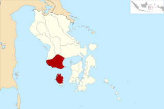
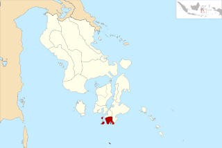
Bombana Regency is a regency of Southeast Sulawesi Province of Indonesia. It consists of part of the southeast peninsula of Sulawesi, together with most of the substantial offshore island of Kabaena to the south. It covers an area of 3,316.16 km2, and had a population on 139,235 at the 2010 Census and 150,706 at the 2020 Census; the official estimate as at mid 2022 was 153,304 - comprising 77,396 males and 75,906 females. The administrative centre lies at the town of Rumbia.
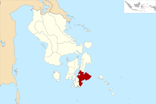
Buton Regency is a regency of Indonesia's Southeast Sulawesi Province, lying entirely on Buton Island. Until 2014 it had an area of 2,681.22 km2, and a population estimated at 276,944. However, in 2014 it was divided into three regencies, with two new regencies being cut out of it; the residual area now is 1,648.04 km2, and the districts in that area contained a population of 94,388 at the 2010 Census while the 2020 Census produced a total of 115,207; the official estimate as at mid 2022 was 119,353.
Muna Regency is a regency of Southeast Sulawesi Province of Indonesia, covering parts of the island of Muna as well as part of the neighbouring Buton Island and smaller islands off its coast. Until 2014 it had an area of 2,945.05 km2, but in that year the western eleven districts of that Regency were split off to form a new West Muna Regency. The reduced regency now covers an area of 2,057.69 km2, and the districts comprising that area had a population of 196,645 at the 2010 Census; the total at the 2020 Census was 215,527, and the official estimate as at mid 2022 was 223,283, comprising 109,458 males and 113,825 females. The principal town lies at Raha, in Katobu District.
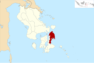
North Buton Regency is a regency of Indonesia's Southeast Sulawesi Province, which was separated from Buton Regency in accordance with Indonesia's Law Number 14 of 2007. The area of the regency, which covers the north part of Buton Island, is 1,923.03 km2. Its population was 54,736 at the 2010 Census and 66,653 at the 2020 Census; the official estimate as at mid 2022 was 69,051. The administrative capital of the regency is at the town of Buranga.
Sugimanuru Airport is a domestic airport located at Raha, the capital of Muna Regency, Southeast Sulawesi province on the island of Sulawesi in Indonesia.
Muna is an Austronesian language spoken principally on the island of Muna as well as North-west Buton Island, off the southeast coast of Sulawesi in Indonesia. the island of Tobea Besar. The language is well-documented, especially by linguist René van den Berg. In 2010, the language had around 270,000 speakers.
West Muna Regency is a new regency of Southeast Sulawesi, Indonesia, established under Act No.14 of 2014, dated 23 July 2014 by separation from the Muna Regency. It covers an area of 906.28 km2, and the districts comprising it had a population of 71,632 at the 2010 Census; the 2020 Census resulted in a population of 84,590, and the official estimate as at mid 2022 was 84,902, comprising 41,909 males and 42,993 females. The administrative centre lies at Laworo in the Tiworo Islands District.

Central Buton Regency is a new regency of Southeast Sulawesi established by separation from Buton Regency under Act No.15 of 2014, dated 23 July 2014. It covers an area of 837.16 km2 comprising the southern parts of Muna Island and Kabaena Island, together with several small offshore islands adjacent to the two main islands, with no territory located on Buton Island. It had a population of 86,112 at the 2010 Census and 114,773 at the 2020 Census; the official estimate as at mid 2022 was 118,904. The administrative centre lies at Labungkari in Lakudo District.
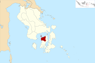
South Buton Regency is a regency located in Southeast Sulawesi. This regency was formed from the southern part of Buton Regency, from which it was separated by Act No.16 of 2014, dated 23 July 2014. It covers an area of 546.58 km2, and the population of the districts now comprising the new regency was 74,974 at the 2010 Census and 95,261 at the 2020 Census; the official estimate as at mid 2022 was 95,613. The regency capital is located in Batauga.


