Related Research Articles

North Sulawesi is a province of Indonesia. It is located on the Minahasa Peninsula of the island of Sulawesi, south of the Philippines and southeast of Sabah, Malaysia. It borders the Philippine province of Davao Occidental and Soccsksargen regions of the Philippines to the north, the Maluku Sea to the east, Gorontalo and Celebes Sea to the west and the Gulf of Tomini to the southwest. With the outlying island of Miangas to its north, it is the northernmost island of Indonesia. The province's area is 14,500.28 square kilometres (5,598.59 sq mi), and its population was 2,270,596 according to the 2010 census; this rose to 2,621,923 at the 2020 Census, while the official estimate as at mid 2022 was 2,659,543. North Sulawesi is known as a heaven for divers around the world.
Indonesia is divided into provinces. Provinces are made up of regencies and cities (kota). Provinces, regencies, and cities have their own local governments and parliamentary bodies.
In Indonesia, village or subdistrict is the fourth-level subdivision and the smallest administrative division of Indonesia below a district, regency/city, and province. Similar administrative divisions outside of Indonesia include barangays in the Philippines, Muban in Thailand, civil townships and incorporated municipalities in the United States and Canada, communes in France and Vietnam, dehestan in Iran, hromada in Ukraine, Gemeinden in Germany, comuni in Italy, or municipios in Spain. The UK equivalent are civil parishes and communities in Wales. There are a number of names and types for villages in Indonesia, with desa being the most frequently used for regencies and kelurahan for cities. According to the 2019 report by the Ministry of Home Affairs, there are 8,488 urban villages and 74,953 rural villages in Indonesia. North Aceh Regency contained the highest number of rural villages (852) amongst all of the regencies of Indonesia, followed by Pidie Regency with 730 rural villages and Bireuen Regency with 609 rural villages. Prabumulih, with only 12 rural villages, contained the fewest. Counted together, the sixteen regencies of Indonesia containing the most rural villages—namely, North Aceh (852), Pidie (730), Bireuen (609), Aceh Besar (604), Tolikara (541), East Aceh (513), Yahukimo (510), Purworejo (469), Lamongan (462), South Nias (459), Kebumen (449), Garut (421), Bojonegoro (419), Bogor (416), Cirebon (412), and Pati (401)—contain one-third of all the rural villages in Indonesia. Five of these are located in Aceh, two in Highland Papua, three in Central Java, two in East Java, three in West Java, and one in North Sumatra. An average number of rural villages in the regencies and 15 cities of Indonesia is 172 villages. A village is the lowest administrative division in Indonesia, and it is the lowest of the four levels. A village is usually divided into a number of hamlets, and there are 252,315 hamlets in Indonesia.

Tomohon is a city in North Sulawesi Province, in central Indonesia. It covers an area of 147.21 km2, and had a population of 91,553 at the 2010 Census, rising to 100,587 at the 2020 Census. The official estimate as at mid 2022 was 101,151. Tomohon was formerly a part of the Minahasa Regency in North Sulawesi, but it officially became a city separated from the Regency, inaugurated on 4 August 2003.

North Central Timor Regency is a regency in East Nusa Tenggara Province, Indonesia. It covers an area of 2,669.70 km2, and had a population of 229,803 at the 2010 Census and 259,829 at the 2020 Census; the official estimate as at mid 2022 was 268,067. Its regency seat is located at the town of Kefamenanu, which had a population of 49,095 in mid 2022. The regency borders Timor Leste's Oecusse enclave, one of few Indonesian regions that have a land border with other countries.

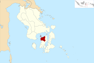
Sitaro Islands Regency is a regency located off the northern extremity of Sulawesi Island in the southern Sangihe Islands, North Sulawesi Province, Indonesia. The regency was formed under Law Number 15 Year 2007 from 2 January 2007, by separation from the Sangihe Islands Regency of which it had previously formed the southern part. The short form of the name is formed from the those of the three principal islands — Siau, Tagulandang and Biaro.

Penajam North Paser Regency is a regency in the Indonesian province of East Kalimantan. Its administrative centre is the town of Penajam. The area which now forms Penajam North Paser was part of Paser Regency until its creation as a separate regency on 10 April 2002. It covers an area of 3,333.06 km2 and it had 142,922 inhabitants at the 2010 census and 178,681 at the 2020 census; the official estimate as at mid 2022 was 183,043. Penajam North Paser Regency has the smallest area among the seven regencies in East Kalimantan province.

Minahasa Regency is a regency in North Sulawesi, Indonesia. Its capital is Tondano. It covers an area of 1,141.64 km2 and had a population of 310,384 at the 2010 Census; this rose to 347,290 at the 2020 Census, and the official estimate as at mid 2022 was 350,317.

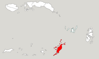
The Sangihe Islands Regency is a regency of North Sulawesi Province, Indonesia. It comprises a group of islands situated to the North of Sulawesi. It covers a land area of 736.98 km2, and had a population of 126,100 at the 2010 census and 139,262 at the 2020 census; the official estimate as at mid 2022 was 140,165. The principal island is also named Sangihe, on which lies the main town of Tahuna. Minor island groups within the Regency include the Marore group considerably to the north of Sangihe Island, the Tatoareng group to the south, and the Nusa Tabukan group off the northeast coast of Sangihe Island. It borders the Philippines in the north, making it one of Indonesia's border regions.

Southeast Maluku Regency is a regency of Maluku, Indonesia. It is coincident with the Kei Islands, except that the city of Tual, although within the Kei Islands geographically and the seat of the Regency's administration, is since 17 July 2007 technically independent of the Regency. The land area of the Regency is 1,016.64 km2, while the sea area administered by the Regency was 3,181 km2; it had a population of 96,442 at the 2010 Census; this increased to 121,511 at the 2020 Census, and the official estimate as at mid 2022 was 124,199.
Tanimbar Islands Regency is a regency of Maluku province, Indonesia, consisting primarily of the Tanimbar Islands. The Regency covers a land area of 10,102 km2, and it had a population of 105,341 at the 2010 Census and 123,572 at the 2020 Census; the official estimate as at mid 2022 was 124,787. The principal town and administrative centre lies at Saumlaki in Tanimbar Selatan District.

Blitar Regency is a regency in East Java, Indonesia. It covers an area of 1,558.79 km2 and had a population of 1,116,639 at the 2010 Census and 1,223,745 at the 2020 Census; the official estimate as at mid 2022 was 1,239,565. These figures exclude Blitar city, which is now a separate administrative entity, enclaved within the regency but completely independent from it. Since 2010, the regency's capital has been located in the town of Kanigoro, after sharing the same capital with Blitar city for more than a century.

Tual is a city in Maluku Province of Indonesia, geographically located within the Kei Islands. On 17 July 2007, it was separated from the rest of the Kei Islands and was created an independent city.
West Muna Regency is a new regency of Southeast Sulawesi, Indonesia, established under Act No.14 of 2014, dated 23 July 2014 by separation from the Muna Regency. It covers an area of 906.28 km2, and the districts comprising it had a population of 71,632 at the 2010 Census; the 2020 Census resulted in a population of 84,590, and the official estimate as at mid 2022 was 84,902, comprising 41,909 males and 42,993 females. The administrative centre lies at Laworo.
This is a list of emblems or coat of arms used in Indonesia. Indonesia is divided into 38 provinces, and each province is divided into regencies (kabupaten) and cities (kota). There are 416 regencies and 98 cities. Each province, regency, and city has its own emblem.
In Indonesian law, the term "city" is generally defined as the second-level administrative subdivision of the Republic of Indonesia, an equivalent to regency. The difference between a city and a regency is that a city has non-agricultural economic activities and a dense urban population, while a regency comprises predominantly rural areas and is larger in area than a city. However, Indonesia historically had several classifications of cities.

Londe or londi is a traditional boat from North Sulawesi, Indonesia. They are thought to have existed since 1500s, developed from ancient Sangir islands boat called bininta which is now enshrined in the symbol of the region of Sangir Islands District.
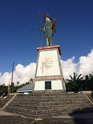
Don Jugov Santiago, popularly known as Bataha Santiago, was the third king of Manganitu Kingdom in Sangihe Islands of modern-day Indonesia. He ruled from 1670 until his death in 1675 and is known for his opposition to opening relations with the Dutch, which resulted in his deposition and execution.
References
- ↑ "Mengenal Wilayah Manado Saat Sebelas Kecamatan" (in Indonesian). Pemerintah Kota Manado. Retrieved 22 February 2018.
- ↑ "Pemerintah Kota Bitung" (in Indonesian). BPK RI Perwakilan Provinsi Sulawesi Utara. Retrieved 22 February 2018.
- ↑ "Ini Kelurahan Dengan Jumlah Pemilih Terbanyak di Kota Tomohon" (in Indonesian). PT BMCOM. Retrieved 22 February 2018.
- ↑ "Desa/Kelurahan" (in Indonesian). Pemerintah Kabupaten Minahasa. Archived from the original on 22 February 2018. Retrieved 22 February 2018.
- ↑ "Kondisi Wilayah" (in Indonesian). Pemerintah Kabupaten Minahasa Selatan. Retrieved 22 February 2018.
- ↑ "Profil Kabupaten Minahasa Utara" (in Indonesian). Disnaker Minut. Archived from the original on 22 February 2018. Retrieved 22 February 2018.
- ↑ "Kondisi Geografi Minahasa Tenggara" (in Indonesian). Pemerintah Kabupaten Minahasa Tenggara. Retrieved 22 February 2018.
- ↑ "Profil & Sejarah Kotamobagu" (in Indonesian). Kota Kotamobagu. Archived from the original on 22 February 2018. Retrieved 22 February 2018.
- ↑ "KPU Bolmong Tetapkan Daftar Pemilih Tetap" (in Indonesian). KPU Kabupaten Bolaang Mongondow. Archived from the original on 22 February 2018. Retrieved 22 February 2018.
- ↑ "KTP Warga Tomini dan Helumo Masih Data Lama" (in Indonesian). DutaDemokrasi.com. Retrieved 22 February 2018.
- ↑ "Penduduk Boltim Tercatat 72.460 Jiwa" (in Indonesian). TRIBUNnews.com Network. Retrieved 22 February 2018.
- ↑ "Daftar Desa, Kelurahan Perkecamatan di Kabupaten Kepulauan Sangihe" (in Indonesian). Pemerintah Kabupaten Kepulauan Sangihe. Retrieved 22 February 2018.
- ↑ "Ini rincian data pemilih Sitaro tiap kecamatan" (in Indonesian). Antara . Retrieved 22 February 2018.