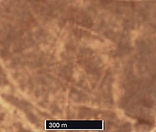
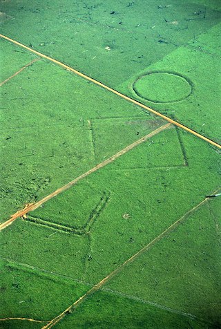
The Steppe Geoglyphs are a number of earth constructions in the Turgai Trough area of Turgai in northern Kazakhstan. There are at least 260 of these earthworks. [1] [2]
The Steppe Geoglyphs are a number of earth constructions in the Turgai Trough area of Turgai in northern Kazakhstan. There are at least 260 of these earthworks. [1] [2]
Many or all of them consist of smaller earthworks (mounds, trenches, and ramparts) arranged with each other to make geometric and other shapes (composite figures). These shapes are squares, rings, and three others. [1] The composite figures range from slightly under 90 m in length to over 400 m in diameter. [3] Besides being made of earth dug out and piled up, some of the geoglyphs are made by placing stones next to each other.[ citation needed ]
Some of the large shapes have been given names, including Bestamskoe Ring, Ushtogaysky (or Ushtogay) Square, Turgay triradial swastika, [4] Large cross Ashtasti, Ekedyn cross, Ashutasti ring, Kyzyloba line, Koga cross, and Shili square. [1] [5]
These shapes are large enough to be easily visible on Google Earth. The Ushtogay Square is at 50°49′59″N65°19′35″E / 50.832933°N 65.326276°E . The Turgay triradial is at 50°06′10″N65°21′39″E / 50.102778°N 65.360833°E , only about 800 metres (1⁄2 mi) from the town of Urpek. Both are inside Amangeldi District, Kostanay Region.
The earthworks were discovered in 2007 by Dimitriy Dey. [6] [7] He found them by searching Google Earth's satellite images for pyramids and similar configurations in Kazakhstan. [6] They were first reported to the scientific community in 2014. [8]
Optical dating (optically stimulated luminescence) has been used to determine that one of the mounds dates to around 8000 B.C.E. [1] [9]
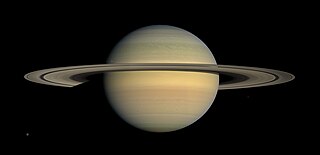
Saturn is the sixth planet from the Sun and the second-largest in the Solar System, after Jupiter. It is a gas giant with an average radius of about nine and a half times that of Earth. It has only one-eighth the average density of Earth, but is over 95 times more massive.
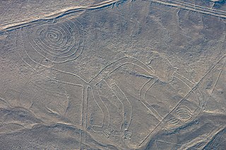
The Nazca Lines are a group of geoglyphs made in the soil of the Nazca Desert in southern Peru. They were created between 500 BC and 500 AD by people making depressions or shallow incisions in the desert floor, removing pebbles and leaving different-colored dirt exposed. There are two major phases of the Nazca lines, Paracas phase, from 400 to 200 BC, and Nazca phase, from 200 BC to 500 AD. In the years leading up to 2020, between 80 and 100 new figures had been found with the use of drones, and archaeologists believe that there are more to be found.
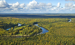
The West Siberian Plain is a large plain that occupies the western portion of Siberia, between the Ural Mountains in the west and the Yenisei River in the east ,and the Altai Mountains on the southeast. Much of the plain is poorly drained and consists of some of the world's largest swamps and floodplains. Important cities include Chelyabinsk, Novosibirsk, Omsk, and Tomsk, as well as Surgut and Nizhnevartovsk.

The moons of Saturn are numerous and diverse, ranging from tiny moonlets only tens of meters across to the enormous Titan, which is larger than the planet Mercury. There are 146 moons with confirmed orbits. This number does not include the many thousands of moonlets embedded within Saturn's dense rings, nor hundreds of possible kilometer-sized distant moons that were seen through telescopes but not recaptured. Seven Saturnian moons are large enough to have collapsed into a relaxed, ellipsoidal shape, though only one or two of those, Titan and possibly Rhea, are currently in hydrostatic equilibrium. Three moons are particularly notable. Titan is the second-largest moon in the Solar System, with a nitrogen-rich Earth-like atmosphere and a landscape featuring river networks and hydrocarbon lakes. Enceladus emits jets of ice from its south-polar region and is covered in a deep layer of snow. Iapetus has contrasting black and white hemispheres as well as an extensive ridge of equatorial mountains among the tallest in the solar system.
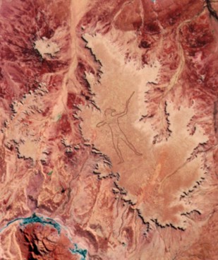
The Marree Man, or Stuart's Giant, is a modern geoglyph discovered in 1998. It appears to depict an Indigenous Australian man hunting with a boomerang or stick. It lies on a plateau at Finnis Springs 60 km (37 mi) west of the township of Marree in central South Australia, approximately 12 km north-west of Callanna. It is just outside the 127,000-square-kilometre (49,000 sq mi) Woomera Prohibited Area. The figure is 2.7 km (1.7 mi) tall with a perimeter of 28 km (17 mi), extending over an area of about 2.5 km2. Although it is one of the largest geoglyphs in the world, its origin remains a mystery, with no one claiming responsibility for its creation nor any eye-witness having been found, notwithstanding the scale of the operation required to form the outline on the plateau floor. The description "Stuart's Giant" was used in anonymous faxes sent to media as "Press Releases" in July 1998, in a reference to the explorer John McDouall Stuart. It was discovered fortuitously by a charter pilot in an overflight on 26 June 1998.
A geoglyph is a large design or motif produced on the ground by durable elements of the landscape, such as stones, stone fragments, gravel, or earth. A positive geoglyph is formed by the arrangement and alignment of materials on the ground in a manner akin to petroforms, while a negative geoglyph is formed by removing part of the natural ground surface to create differently coloured or textured ground in a manner akin to petroglyphs.

A hill figure is a large visual representation created by cutting into a steep hillside and revealing the underlying geology. It is a type of geoglyph usually designed to be seen from afar rather than above. In some cases trenches are dug and rubble made from material brighter than the natural bedrock is placed into them. The new material is often chalk, a soft and white form of limestone, leading to the alternative name of chalk figure for this form of art.

The Kazakh Steppe, also called the Great Dala, is a vast region of open grassland in northern Kazakhstan and adjacent portions of Russia. It lies east of the Pontic steppe and west of the Emin Valley steppe, with which it forms part of the Eurasian steppe. The Kazakh Steppe is an ecoregion of the temperate grasslands, savannas, and shrublands biome in the Palearctic realm. Before the mid-nineteenth century it was called the Kirghiz steppe, 'Kirghiz' being an old Russian word for the Kazakhs.

In archaeology, earthworks are artificial changes in land level, typically made from piles of artificially placed or sculpted rocks and soil. Earthworks can themselves be archaeological features, or they can show features beneath the surface.
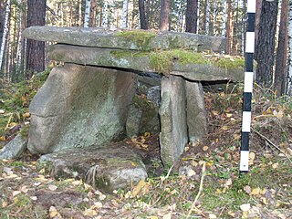
In recent years, many megaliths have been discovered in the Urals: dolmens, menhirs and a large megalithic cultic complex on Vera Island.
Urpek is a village in Amangeldi District of Kostanay Region, northern Kazakhstan.
This page is a glossary of archaeology, the study of the human past from material remains.

The Boha geoglyphs or Great Indian Desert geoglyph are a group of large geoglyphs made in the soil in the Thar Desert of Rajasthan, India. Several sites were found located around the city of Jaisalmer, marked by geometrical lines resembling geoglyphs. The lines that make up these figures are stripes etched into the ground, ranging up to 10 centimeters deep and spreading 20 to 50 cm wide. The sizes of the glyphs are so large that it is believed that its creators must not have been able to view them in its entirety. The largest of these glyphs are in the vicinity of the village of Boha near Jaiselmer. The Boha geoglyph is made of a succession of concentric and linear outlines and spans over 100,000 square metres, making it far larger than the Nazca Lines geoglyph in southern Peru, or any other known geoglyph. The geoglyphs were discovered by French researchers Carlo Oetheimer and Yohann Oetheimer, initially using Google Earth.

The Turgay Depression, also known as Turgay Basin, Turgay Trough, and Turgay Hollow, is a structural basin in Kazakhstan.

The Barsuki Desert is a desert zone in the Aktobe and Kyzylorda regions of Kazakhstan. It has two parts, the Greater Barsuki in the west and the Lesser Barsuki in the east. They are elongated strips of sand desert parallel to each other and separated by a roughly 65 kilometers (40 mi) wide stretch of non-desert terrain.
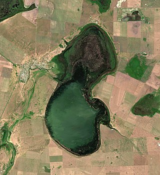
Sarykopa is a bittern salt lake in the Kostanay Region, Kazakhstan.

Aksuat is a brackish lake in the Kostanay Region, Kazakhstan.
Koybagar is a lake in the Kostanay Region, Kazakhstan.

Tyuntyugur is a lake in the Kostanay Region, Kazakhstan.

The Ulkayak is a river in Kazakhstan. It has a length of 349 kilometres (217 mi) and a catchment area of 13,300 square kilometres (5,100 sq mi).
Since then, Dey has found about 260 of the land designs—which resemble crop circles, but are much stranger.
More than 50 geoglyphs with various shapes and sizes, including a massive swastika, have been discovered across northern Kazakhstan in Central Asia, say archaeologists.
Spotted on Google Earth in 2007 by a Kazakh economist and archaeology enthusiast, Dmitriy Dey, the so-called Steppe Geoglyphs remain deeply puzzling and largely unknown to the outside world.
Discovered using Google Earth, the geoglyphs are designed...