The geography of Mozambique consists mostly of coastal lowlands with uplands in its center and high plateaus in the northwest. There are also mountains in the western portion. The country is located on the east coast of southern Africa, directly west of the island of Madagascar. Mozambique has a tropical climate with two seasons, a wet season from October to March and a dry season from April to September.

The Mozambique Channel is an arm of the Indian Ocean located between the Southeast African countries of Madagascar and Mozambique. The channel is about 1,700 km long and 419 km across at its narrowest point, and reaches a depth of 3,292 m (10,801 ft) about 230 km off the coast of Mozambique. A warm current, the Mozambique Current, flows in a southward direction in the channel, leading into the Agulhas Current off the east coast of Southern Africa.

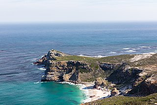
The Cape of Good Hope is a rocky headland on the Atlantic coast of the Cape Peninsula in South Africa.

Portuguese Mozambique or Portuguese East Africa were the common terms by which Mozambique was designated during the period in which it was a Portuguese colony. Portuguese Mozambique originally constituted a string of Portuguese possessions along the south-east African coast, and later became a unified colony, which now forms the Republic of Mozambique.

Cabo Delgado is the northernmost province of Mozambique. It has an area of 82,625 km2 (31,902 sq mi) and a population of 2,320,261 (2017). As well as bordering Mtwara Region in the neighboring country of Tanzania, it borders the provinces of Nampula and Niassa. The region is an ethnic stronghold of the Makonde tribe, with the Makua and Mwani as leading ethnic minorities.

Ruvuma River, formerly also known as the Rovuma River, is a river in the African Great Lakes region. During the greater part of its course, it forms the border between Tanzania and Mozambique. The river is 998 km (620 mi) long, with a drainage basin of ~155,000 km2 (60,000 sq mi) in size. Its mean annual discharge is 475 m3/s (16,800 cu ft/s) to 2,286 m3/s (80,700 cu ft/s) at its mouth.

Mocímboa da Praia is a port town in northern Mozambique, lying on the Indian Ocean coast, in Cabo Delgado Province. It is used as a border post for travel to and from Tanzania even though it is 127 km from the border by road. It is the seat of Mocímboa da Praia District.

Mozambique is a Christian majority country, with Islam being a minority faith practiced by around 17.5% of the population as of 2020. The faith was introduced by merchants visiting the Swahili coast, as the region was part of the trade network that spanned the Indian Ocean. This later led to the formation of several officially Muslim political entities in the region.

The Unity Bridge across Ruvuma River at Negomano, Mozambique, between Tanzania and Mozambique, was proposed as early as 1975, shortly after Mozambique's independence. It was the idea of the two countries' former Presidents, Mwalimu Nyerere and Samora Machel. Several design studies and limited construction work were completed in the early 1980s, but the Unity Bridge was not finished due to lack of funds.

Niassa Reserve is a nature reserve in Cabo Delgado Province and Niassa Province, Mozambique. Covering over 42,000 square kilometres, it is the largest protected area in the country. The reserve is part of the Trans-Frontier Conservation Area and links to the Tanzanian Lukwika-Lumesule Game Reserve. It will connect to the Lake Niassa Reserve when it is completed.

Quissanga District is a district of Cabo Delgado Province in northern Mozambique. It covers 2,118 square kilometres (818 sq mi) with a population of 50,259 as of 2017.
A headland, also known as a head, is a coastal landform, a point of land usually high and often with a sheer drop, that extends into a body of water. It is a type of promontory. A headland of considerable size often is called a cape. Headlands are characterised by high, breaking waves, rocky shores, intense erosion, and steep sea cliff.

The Messalo is a major river of northeastern Mozambique. It flows through Niassa Province and Cabo Delgado Province, passes near Chai, and flows into the Mozambique Channel of the Indian Ocean at Quiterajo beach at 11°40′25″S40°26′25″E. The Messalo River is 530 km (330 mi) in length while the Messalo River Basin is 24,000 km2 (9,300 sq mi) in size. The river flooded its banks in March 2000 during the 2000 Mozambique flood.
Negomano or Ngomano is a village in northern Mozambique, in Cabo Delgado Province. It is located on the border with Tanzania on the confluence of the Ruvuma River and the Lugenda River.
The Ironclad gas field is a natural gas field located offshore the Cabo Delgado Province of Mozambique. Discovered in 2012, it was developed by Anadarko Petroleum, determining it to have initial total proven reserves of around 5 trillion ft3 (143 km3). It began production of natural gas and condensates later that year, with a production rate of around 50 million ft3/day (1.9×10⁵ m3).

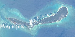
Vamizi Island is situated in the far north of Mozambique in the Quirimbas Archipelago. The island is recognised as one of the leading luxury private islands and conservation projects in East Africa and the Indian Ocean.

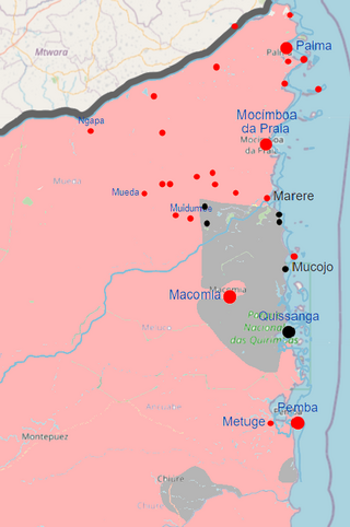
The insurgency in Cabo Delgado is an ongoing Islamist insurgency in Cabo Delgado Province, Mozambique, mainly fought between militant Islamists and jihadists attempting to establish an Islamic state in the region, and Mozambican security forces. Civilians have been the main targets of terrorist attacks by Islamist militants. The main insurgent faction is Ansar al-Sunna, a native extremist faction with tenuous international connections. From mid-2018, the Islamic State's Central Africa Province has allegedly become active in northern Mozambique as well, and claimed its first attack against Mozambican security forces in June 2019. In addition, bandits have exploited the rebellion to carry out raids. As of 2020, the insurgency intensified, as in the first half of 2020 there were nearly as many attacks carried out as in the whole of 2019.
This article lists events from the year 2020 in Mozambique.
This article lists events from the year 2021 in Mozambique.

The Mwani people are a Bantu ethnic group primarily inhabiting the coastline of the Cabo Delgado Province of Mozambique. The Mwani people speak the Kimwani language, also known as the Ibo language, which is a Bantu language belonging to the Niger-Congo language family. They are often considered part of the Swahili cultural world as they have important connections with the East African coast


