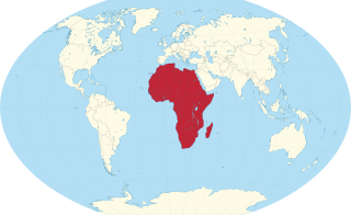
Africa is a continent comprising 63 political territories, representing the largest of the great southward projections from the main mass of Earth's surface. Within its regular outline, it comprises an area of 30,368,609 km2 (11,725,385 sq mi), excluding adjacent islands. Its highest mountain is Mount Kilimanjaro; its largest lake is Lake Victoria.
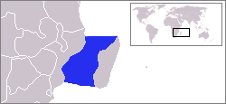
The Mozambique Channel is an arm of the Indian Ocean located between the Southeast African countries of Madagascar and Mozambique. The channel is about 1,700 km long and 419 km across at its narrowest point, and reaches a depth of 3,292 m (10,801 ft) about 230 km off the coast of Mozambique. A warm current, the Mozambique Current, flows in a southward direction in the channel, leading into the Agulhas Current off the east coast of Southern Africa.

Western Sahara is a territory in Northern Africa, bordered by the North Atlantic Ocean, Morocco proper, Algeria, and Mauritania. Geographic coordinates: 24°30′N13°00′W

Cape Guardafui is a headland in the autonomous Puntland region in Somalia. Coextensive with Puntland's Gardafuul administrative province, it forms the geographical apex of the Horn of Africa. Its shore at 51°27'52"E is the second easternmost point on mainland Africa after Ras Hafun. The offshore oceanic strait Guardafui Channel is named after it.

Cape Juby is a cape on the coast of southern Morocco, near the border with Western Sahara, directly east of the Canary Islands.
The extreme points of Africa are the points that are farther north, south, east or west than any other location on the continent.

Ras Hafun, also known as Cape Hafun, is a promontory in the northeastern Bari region of Somalia. Jutting out into the Guardafui Channel, it constitutes the easternmost point in Africa. The area is situated near the Cape Guardafui headland. It is joined to the mainland at the town of Foar, by a sand spit 20.0 km (12.4 mi) long, 1.0–3.0 km (0.62–1.86 mi) in width, and 5.0 m (16.4 ft) above sea level. The fishing town of Hafun is located on the promontory, 2.0 km (1.2 mi) east of the sand spit.

Qikiqtaaluk (ᕿᑭᖅᑖᓗᒃ), formerly White Island, is one of the uninhabited Canadian arctic islands in the Kivalliq Region, Nunavut, Canada. Located in Foxe Basin off the northern tip of Southampton Island, it measures 789 km2 (305 sq mi) in area.

Masirah Island, also referred to as Mazeira Island or Wilāyat Maṣīrah, is an island off the east coast of mainland Oman in the Arabian Sea, and the largest island of the country. It is 95 km (59 mi) long north–south, between 12 and 14 km wide, with an area of about 649 km2, and a population estimated at 12,000 in 12 villages mainly in the north of the island.

Cape Bon, also known as Ras at-Taib, Sharīk Peninsula, or Watan el Kibli, is a peninsula in far northeastern Tunisia. Cape Bon is also the name of the northernmost point on the peninsula, also known as Ras ed-Dar, and known in antiquity as the Cape of Mercury or Cape Hermaeum.

Cape Wrath Lighthouse at Cape Wrath was built in 1828 by Robert Stevenson and was manned until 1998, when it was converted to automatic operation by the Northern Lighthouse Board. It is located at the most North-Westerly point on the British mainland, in the traditional county of Sutherland within Highland Region. Durness is the closest village, 10 miles (16 km) to the south-east with Inverness around 120 miles (190 km) to the south.

The following outline is provided as an overview of and topical guide to Tunisia:
A headland, also known as a head, is a coastal landform, a point of land usually high and often with a sheer drop, that extends into a body of water. It is a type of promontory. A headland of considerable size often is called a cape. Headlands are characterised by high, breaking waves, rocky shores, intense erosion, and steep sea cliff.
Halaib, is a Red Sea port and town, located in the Halaib Triangle, a 20,580 km2 (7,950 sq mi) area disputed between Egypt and Sudan. The town lies on the southern tip of what Egyptians refer to as the Red Sea Riviera and the north eastern corner of Sudan's Red Sea State and is near the ruins of medieval ʽAydhab. De facto control of the area is held by the Egyptian government.
Tunisia, officially the Tunisian Republic, is the northernmost country in Africa. It is a Maghreb country and is bordered by Algeria to the west, Libya to the southeast, and the Mediterranean Sea to the north and east. Its area is almost 165,000 square kilometres (64,000 sq mi), with an estimated population of just over 10.4 million. Its name is derived from the capital Tunis located in the north-east.

Cape Zebib is a headland in northern Tunisia near the town of Metline. The bay between Cape Guardia and Cape Zebib has the sandy Skala Beach; Skala was also an ancient port. Bizerte stands on the lowest part of the coast, which thence gradually rises to the cape. Jebel Kshapta is 13 mi (21 km) to the south-west of the cape.

Cape Spartel is a promontory in Morocco about 1,000 feet (300 m) above sea level at the entrance to the Strait of Gibraltar, 12 km west of Tangier. Below the cape are the Caves of Hercules.

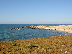
Cape Angela is a rocky headland in Bizerte, Tunisia. Its tip, Ras Ben Sakka, has been considered the northernmost point of the African continent since 2014, replacing Cape Blanc, also in Tunisia. It is located about 15 kilometers (9.3 mi) from Bizerte, the northernmost city in Africa and 22 kilometers (14 mi) from Ichkeul Lake.

The Guardafui Channel is an oceanic strait off the tip of the Horn of Africa that lies between the Puntland region of Somalia and Socotra to the west of the Arabian Sea. It connects the Gulf of Aden to the north with the Indian Ocean to the south. Its namesake is Cape Guardafui, the very tip of the Horn of Africa. Notable places of interest include the Alula Lagoon.
Abyad, also transliterated abiad, is an Arabic word meaning 'white'. It may refer to:
 Monument
 Monument