
The South West Coast Path is England's longest waymarked long-distance footpath and a National Trail. It stretches for 630 miles (1,014 km), running from Minehead in Somerset, along the coasts of Devon and Cornwall, to Poole Harbour in Dorset. Because it rises and falls with every river mouth, it is also one of the more challenging trails. The total height climbed has been calculated to be 114,931 ft (35,031 m), almost four times the height of Mount Everest. It has been voted 'Britain's Best Walking route' twice in a row by readers of The Ramblers' Walk magazine, and regularly features in lists of the world's best walks.
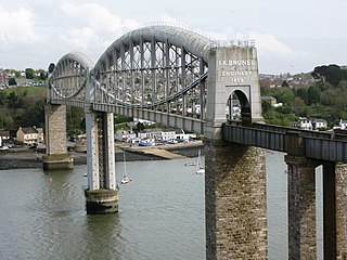
The Royal Albert Bridge is a railway bridge which spans the River Tamar in England between Plymouth, Devon and Saltash, Cornwall. Its unique design consists of two 455-foot (138.7 m) lenticular iron trusses 100 feet (30.5 m) above the water, with conventional plate-girder approach spans. This gives it a total length of 2,187.5 feet (666.8 m). It carries the Cornish Main Line railway in and out of Cornwall. It is adjacent to the Tamar Bridge which opened in 1962 to carry the A38 road.

South Hams is a local government district on the south coast of Devon, England. Services divide between those provided by its own Council headquartered in Totnes, and those provided by Devon County Council headquartered in the city of Exeter.

Salcombe is a popular resort town in the South Hams district of Devon, south west England. The town is close to the mouth of the Kingsbridge Estuary, mostly built on the steep west side of the estuary. It lies within the South Devon Area of Outstanding Natural Beauty (AONB). The town's extensive waterfront and the naturally sheltered harbour formed by the estuary gave rise to its success as a boat and shipbuilding and sailing port and, in modern times, tourism especially in the form of pleasure boats and yachting. The town is also home to a traditional shellfish fishing industry. The town is part of the electoral ward of Salcombe and Malborough, for which the 2011 census recorded a total population of 3,353.

A promontory fort is a defensive structure located above a steep cliff, often only connected to the mainland by a small neck of land, thus using the topography to reduce the ramparts needed. Although their dating is problematic, most seem to date to the Iron Age. They are mainly found in Brittany, Ireland, the Orkney Islands, the Isle of Man, Devon and Cornwall.

East Portlemouth is a small Devon village situated at the southern end of the Kingsbridge Estuary, on the south Devon Coast. The population of this parish taken at the 2011 census was 162. The village is sited on a hill giving views to the north to Kingsbridge and on a clear day as far as Dartmoor. There is a small ferry that runs to Salcombe and a beach that is popular with holidaymakers.

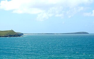
The Kingsbridge Estuary in the South Hams area of Devon, England runs from Kingsbridge in the north to its mouth at the English Channel near Salcombe and lies between Bolt Head and Sharpitor to the west and Portlemouth Down to the east. The estuary is some 8.6 kilometres (5.3 mi) in length, with numerous side channels. Several of its creeks have independent names, including Blanksmill, Frogmore, Southpool, Batson and Bowcombe Creek.

South Pool is a village, parish and former manor in South Devon, England. It is situated 3 1/2 miles south-east of the town of Kingsbridge and 2 1/2 miles north-east of Salcombe. It is administered by the South Hams local authority. Historically it formed part of Coleridge Hundred. It falls within Woodleigh Deanery for ecclesiastical purposes. The village is in an area of outstanding natural beauty at the head of South Pool creek.
Rame Head or Ram Head is a coastal headland, southwest of the village of Rame in southeast Cornwall, United Kingdom. It is part of the larger Rame Peninsula.
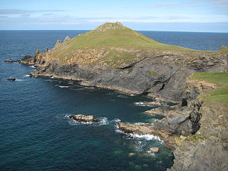
The Rumps is a twin-headland promontory at the north-east corner of Pentire Head in north Cornwall, United Kingdom.
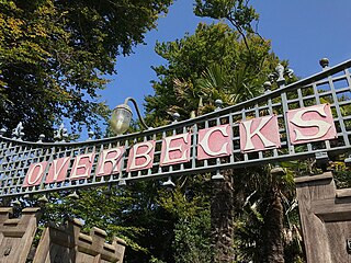
Overbeck's Museum and Garden is an Edwardian house and 2.75 hectare garden at Sharpitor, Salcombe, Devon, England. It is named after its last private owner Otto Christop Joseph Gerhardt Ludwig Overbeck (1860–1937).

Hingston Down is a hill not far from Gunnislake in Cornwall, England, United Kingdom. It is the subject of an old rhyme, due to the prolific tin mining that formerly took place in the area:
Hingston Down well ywrought
Is worth London Town dearly bought.
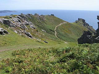
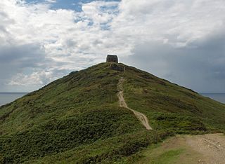
Bolt Head is a National Trust headland on the South Coast of Devon, England, United Kingdom, situated west of the Kingsbridge Estuary. It is a popular viewpoint on the South West Coast Path between Hope Cove, Bolt Tail, Bolberry Down and Salcombe.

Bolberry Down is a clifftop area on the coast of Devon, England. The headland of Bolt Tail lies to the west and Bolt Head and the town of Salcombe to the east. It is one of the longest coastal areas owned by the National Trust and lies within the South Devon Area of Outstanding Natural Beauty.
Trevose Head is a headland on the Atlantic coast of north Cornwall, United Kingdom. It is situated approximately 5 miles (8.0 km) west of Padstow. The South West Coast Path runs around the whole promontory and is within the Cornwall Area of Outstanding Natural Beauty and the Trevose Head Heritage Coast. In clear weather, visitors to Trevose Head can see virtually the whole length of the north Cornwall coast; to the north, the view extends beyond the Cornwall county boundary to Hartland Point, Devon; to the south, it extends beyond St Ives to the headland at Pendeen Watch.

Gribbin Head is a promontory on the south coast of Cornwall, England, UK, owned and managed by the National Trust. It separates St Austell Bay from the estuary of the River Fowey and is marked by a large tower used to aid navigation of ships approaching the local harbours. The nearest town is Fowey. The western point of the headland is called Little Gribbin.
Devon League 1, is an English level nine, rugby union league for clubs based in Devon. The champions are promoted to Cornwall/Devon and the runner-up plays the second team from Cornwall League 1, with the winning team gaining promotion. Up until the end of the 2017–18 season, teams were relegated to Devon League 2 but since that league has been abolished there is currently no relegation.
Devon League 2 was an English level ten rugby union league for clubs based in Devon; with one exception. The champions and runners-up are promoted to Devon League 1, and since the cancellation of Devon League 3 in 2003 there was no relegation as this is the lowest division in club rugby union within Devon.
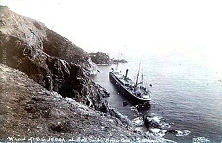
SS Jebba was a steam ship that ran aground near Bolt Tail, off the coast of Devon, England in 1907. Built by Sir Raylton Dixon & Company, Middlesbrough, she was launched in 1896 as the SS Albertville for the Cie. Belge-Maritime du Congo, Antwerp. They sold her in 1898 to Elder Dempster & Co, Liverpool, who renamed her Jebba.
