
Rose Bay is a harbourside eastern suburb of Sydney, in the state of New South Wales, Australia. Rose Bay is located seven kilometres east of the Sydney central business district, in the local government areas of Municipality of Woollahra and Waverley Council.

The Eastern Suburbs is the eastern metropolitan region of Sydney, New South Wales, Australia.

John Gatenby Bolton was a British-Australian astronomer who was fundamental to the development of radio astronomy. In particular, Bolton was integral in establishing that discrete radio sources were either galaxies or the remnants of supernovae, rather than stars. He also played a significant role in the discovery of quasars and the centre of the Milky Way. Bolton served as the inaugural director of the Parkes radio telescope in Australia and established the Owens Valley Radio Observatory in California. Bolton's students held directorships at most of the radio observatories in the world and one was a Nobel Prize winner. Bolton is considered a key figure in the development of astronomy in Australia.

Moore Park is a suburb in the Eastern Suburbs of Sydney located 3 kilometres (1.9 mi) from the CBD, in the state of New South Wales, Australia. It is part of local government area of the City of Sydney.

The Division of Wentworth is an Australian electoral division in the state of New South Wales. The division encompasses the suburbs to the east of Sydney CBD, mostly Woollahra and Waverley council in Sydney's Eastern Suburbs.

Watsons Bay is a harbourside, eastern suburb of Sydney, in the state of New South Wales, Australia. Watsons Bay is located 11 km north-east of the Sydney central business district, in the local government area of the Municipality of Woollahra.
Vaucluse is an eastern suburb of Sydney, in the state of New South Wales, Australia. It is located 8 kilometres (5 mi) east of the Sydney central business district, in the local government areas of Waverley Council and the Municipality of Woollahra.

Edgecliff is a small suburb in the Eastern Suburbs of Sydney, in the state of New South Wales, Australia. Edgecliff is located 4 kilometres east of the Sydney central business district, in the local government area of the Municipality of Woollahra. The postcode is 2027.

North Bondi is a coastal, eastern suburb of Sydney, in the state of New South Wales, Australia 7 kilometres east of the Sydney central business district, in the local government area of Waverley Council.
Middle Cove is a suburb on the Lower North Shore of Sydney, in the state of New South Wales, Australia 9 kilometres north of the Sydney central business district, in the local government area of the City of Willoughby.
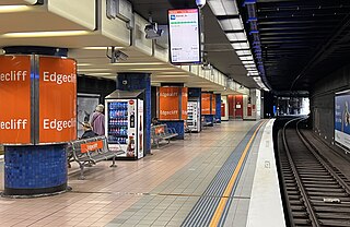
Edgecliff railway station is a heritage-listed underground commuter railway station located on the Eastern Suburbs line, serving the Sydney suburb of Edgecliff. It is served by Sydney Trains' T4 Eastern Suburbs & Illawarra Line services and NSW TrainLink's South Coast Line services.

Rose Bay Secondary College (RBSC) is a government-funded co-educational dual modality partially academically selective and comprehensive secondary day school, located in Dover Heights, an eastern Sydney suburb of New South Wales, Australia. The New South Wales Department of Education established the college in 2003 as a result of the merger of Dover Heights and Vaucluse high schools.

Vaucluse is an electoral district of the Legislative Assembly in the Australian state of New South Wales, located east of the Sydney central business district in the affluent Eastern Suburbs. It is named after the suburb of Vaucluse.

Tourism in Sydney forms an important part of the city's economy. The city received 12 million domestic visitors and 4.1 million international visitors in year ending June 2019. The most famous attractions include the Sydney Opera House, and the Sydney Harbour Bridge. Other attractions include the Sydney Mardi Gras, Royal Botanical Gardens, Luna Park, the beaches and Sydney Tower.
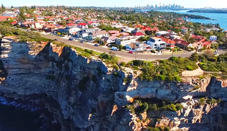
The Gap is an ocean cliff at South Head in the Eastern Suburbs of Sydney, Australia. The area, which faces the Tasman Sea, is located in the suburb of Watsons Bay. Although the cliff is a popular tourist destination, it has infamy for suicides.

}}

Old South Head Road is a major road in Sydney, linking the eastern suburb of Bondi Junction to Watsons Bay on the South Head peninsula. It is historically significant because its earliest origins can be traced back to the early days of the colony of New South Wales.
Dover Heights Boys High School was a former public single-sex secondary day school for boys, that was located in the eastern Sydney suburb of Dover Heights, New South Wales, Australia.
The Bondi Ocean Outfall Sewer is a heritage-listed sewerage infrastructure at Blair Street, North Bondi, Sydney, Australia. The sewer line commences at the intersection of Oxford Street and College Street in Darlinghurst and then travels in a more-or-less easterly direction for 6.1 kilometres (3.8 mi) passing through a number of suburbs until it reaches Blair Street in North Bondi. It was designed and built by the Public Works Department between 1880 and 1889. It is also known as BOOS (Bondi Ocean Outfall Sewer) and Main Northern Ocean Outfall Sewer. The property is owned by Sydney Water.


