Breakfast Point, New South Wales

Last updated

Breakfast Point
Sydney,  New South Wales
Breakfast Point Park.JPG
Park at Breakfast Point
Breakfast Point, New South Wales
Population4,678 (2021 census) [1]
 • Density9,400/km2 (24,200/sq mi)
Established16 April 1993
Postcode(s) 2137
Elevation20 m (66 ft)
Area0.5 km2 (0.2 sq mi)
Location16 km (10 mi) west of Sydney CBD
LGA(s) City of Canada Bay
State electorate(s) Drummoyne
Federal division(s) Reid
Suburbs around Breakfast Point:
Putney Tennyson Point Gladesville
Mortlake Breakfast Point Cabarita
Concord Concord Cabarita

Breakfast Point is a suburb in the Inner West of Sydney, in the state of New South Wales, Australia. Breakfast Point is located 16 kilometres west of the Sydney central business district. It is in the local government area of the City of Canada Bay. [2] People from Breakfast Point are colloquially called Breakfast Pointers.

Contents

History

The area now occupied by Breakfast Point was previously part of Mortlake. The suburb is named after a geographical headland, named "Breakfast Point", to the east of Mortlake Point and to the west of Cabarita, and the suburb name was gazetted in 1993. [3]

Flag formerly flown on the flagpole along the Parramatta River, a modified version is still used by the Breakfast Point Country Club. Flag of Breakfast Point, New South Wales.png
Flag formerly flown on the flagpole along the Parramatta River, a modified version is still used by the Breakfast Point Country Club.

According to historical records, the name of the point - and therefore the suburb name - is derived from the first contact between Europeans and the traditional owners of the land, the Wangal Clan. The encounter took place on 5 February 1788 during Captain John Hunter's exploration of the Parramatta River, while Hunter was having breakfast. [4] William Bradley, First Lieutenant on board HMS Sirius, recorded the following entry in the log:

We landed to cook breakfast on the opposite shore to them (Breakfast Pt.). We made signs to them to come over and waved green boughs. Soon after which 7 of them came over in 2 canoes and landed near our boats. They left their spears in the canoes and came to us. We tied beads etc. about them and left them our fire to dress their muscles which they went about as soon as our boats put off. [5]

Hunter, who was later to become Governor of New South Wales, is also remembered in the name of the nearby suburb of Hunters Hill. [6]

Much of the area at Breakfast Point was occupied by the Mortlake Gas Works of the Australian Gaslight Company (AGL). AGL began developing the site from 1883. The Mortlake Gasworks site offered river access for colliers—known as 'sixty milers'—to bring coal and virtually unlimited space for expansion. The gas works remained in operation until the 1990s when in 1998 AGL, after a selected tender process, selected Rosecorp Pty. Ltd. to progressively acquire and develop the Mortlake site. Redevelopment has proceeded since then. [7]

Demographics

Breakfast Point Community Hall Breakfast Point Community Hall.JPG
Breakfast Point Community Hall

According to the 2016 census of population, there were 4,188 residents in Breakfast Point. 53.9% of people were born in Australia. The next most common countries of birth were China 11.0%, England 4.0% and South Korea 2.7%. The most common ancestries in Breakfast Point were English 18.0%, Chinese 15.2%, Australian 13.9%, Irish 8.0% and Italian 6.9%. 57.3% of people spoke only English at home. Other languages spoken at home included Mandarin 11.3%, Cantonese 5.0%, Korean 3.4% and Italian 3.2%. The most common responses for religion were Catholic 30.9%, No Religion 28.7% and Anglican 10.9%. [1]

Commercial area

Breakfast Point also has a little town centre with IGA supermarket, The Olive Kitchen restaurant, Il Punto Pizzeria, two clothing shops, a hairdressers, day spa and one dental surgery at Canada Bay Dental. Further developments are planned. These developments are located opposite the historic Palace Hotel in Tennyson Road.

Housing

A former blacksmith's workshop, surrounded by residential apartments Former Blacksmith's workshop - Breakfast Point, NSW (7834181174).jpg
A former blacksmith's workshop, surrounded by residential apartments

Breakfast Point is the location of one of the largest urban renewal projects in Sydney on a site formerly belonging to AGL. The New South Wales State Government took control of the approval process for the development from Canada Bay Council in August 2005, citing lengthy delays. Issues that arose between the council and the developer, Rosecorp, included the provision of public transport, public access to the area and its landscaping. [8] There are several streets with architecturally designed modern houses and many modern apartment blocks in the suburb, such as Hunter's Wharf on the Parramatta River.

Related Research Articles

<span class="mw-page-title-main">Port Jackson</span> Body of water in Sydney, Australia

Port Jackson, consisting of the waters of Sydney Harbour, Middle Harbour, North Harbour and the Lane Cove and Parramatta Rivers, is the ria or natural harbour of Sydney, New South Wales, Australia. The harbour is an inlet of the Tasman Sea. It is the location of the Sydney Opera House and Sydney Harbour Bridge. The location of the first European settlement and colony on the Australian mainland, Port Jackson has continued to play a key role in the history and development of Sydney.

<span class="mw-page-title-main">Gladesville Bridge</span> Bridge in Sydney, Australia

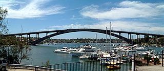
Gladesville Bridge is a heritage-listed concrete arch road bridge that carries Victoria Road over the Parramatta River, linking the Sydney suburbs of Huntleys Point and Drummoyne, in the local government areas of Canada Bay and Hunter's Hill, in New South Wales, Australia. Despite its name, the bridge is not in Gladesville.

<span class="mw-page-title-main">Parramatta River</span> River in Australia

The Parramatta River is an intermediate tide-dominated, drowned valley estuary located in Sydney, New South Wales, Australia. With an average depth of 5.1 metres (17 ft), the Parramatta River is the main tributary of Sydney Harbour, a branch of Port Jackson. Secondary tributaries include the smaller Lane Cove and Duck rivers.

<span class="mw-page-title-main">Homebush Bay</span> Suburb of Sydney, New South Wales, Australia

Homebush Bay is a bay on the south bank of the Parramatta River, in the west of Sydney, Australia. The name is also sometimes used to refer to an area to the west and south of the bay itself, which was formerly an official suburb of Sydney, and has now become the suburbs of Sydney Olympic Park, Wentworth Point and part of the neighbouring suburb of Lidcombe, all part of the City of Parramatta. Homebush Bay is located 13 kilometres (8.1 mi) west of the Sydney central business district.

<span class="mw-page-title-main">Croydon, New South Wales</span> Suburb of Sydney, New South Wales, Australia

Croydon is a suburb in the Inner West of Sydney, in the state of New South Wales, Australia. It is located 9 kilometres (5.6 mi) west of the Sydney central business district. Croydon is split between the two local government areas of Municipality of Burwood and the Inner West Council.

<span class="mw-page-title-main">Canada Bay, New South Wales</span> Suburb of Sydney, Australia

Canada Bay is a suburb in the Inner West of Sydney, in the state of New South Wales, Australia. It is 11 kilometres (6.8 mi) west of the Sydney central business district, in the local government area of City of Canada Bay.

<span class="mw-page-title-main">City of Canada Bay</span> Local government area in New South Wales, Australia

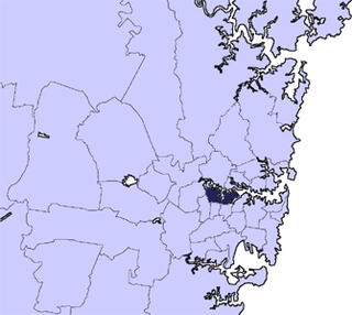
The City of Canada Bay is a local government area just outside the Inner West of Sydney, New South Wales, Australia. The city was formed on 1 December 2000, following the merger of Concord and Drummoyne councils. The city covers an area of 19.82 square kilometres (7.65 sq mi) and as at the 2021 census had a resident population of 89,177. The city is ultimately named after Canada Bay, a bay and suburb along the Parramatta River.

<span class="mw-page-title-main">Five Dock</span> Suburb of Sydney, New South Wales, Australia

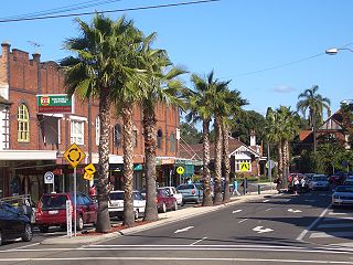
Five Dock is a suburb in the Inner West of Sydney, in the state of New South Wales, Australia. Five Dock is located 10 kilometres west of the Sydney central business district, in the local government area of the City of Canada Bay.

<span class="mw-page-title-main">Division of Lowe</span> Former Australian federal electoral division

The Division of Lowe was an Australian Electoral Division in the state of New South Wales. It was located in the inner western suburbs of Sydney, on the south shore of the Parramatta River. It included the suburbs of Drummoyne, Five Dock, Croydon, Croydon Park, Burwood, Enfield, Homebush, Strathfield, Concord, Rhodes, Canada Bay, Cabarita, Abbotsford and Mortlake.

<span class="mw-page-title-main">Gladesville</span> Suburb of Sydney, New South Wales, Australia

Gladesville is a suburb in the Lower North Shore of Sydney, in the state of New South Wales, Australia. Gladesville is located 10 kilometres north-west of the Sydney central business district, in the local government area of the City of Ryde and the Municipality of Hunter's Hill. Gladesville is part of the federal electorates of North Sydney and Bennelong.

<span class="mw-page-title-main">Putney, New South Wales</span> Suburb of Sydney, New South Wales, Australia

Putney is a suburb of Northern Sydney, New South Wales, Australia. It is located 14 kilometres (9 mi) north-west of the Sydney central business district on the northern bank of the Parramatta River. Its local government area is the City of Ryde.

<span class="mw-page-title-main">Mortlake, New South Wales</span> Suburb of Sydney, New South Wales, Australia

Mortlake is a suburb in the Inner West of Sydney, in the state of New South Wales, Australia. It is 10 kilometres west of the Sydney central business district, in the local government area of the City of Canada Bay.

<span class="mw-page-title-main">Concord, New South Wales</span> Suburb of Sydney, New South Wales, Australia

Concord is a suburb in the inner West of Sydney, in the state of New South Wales, Australia. It is 10 kilometres (6.2 mi) west of the Sydney central business district, in the local government area of the City of Canada Bay. Concord West is a separate suburb, to the north-west.

<span class="mw-page-title-main">Drummoyne</span> Suburb of Sydney, New South Wales, Australia

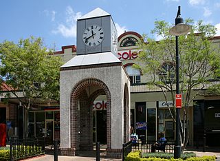
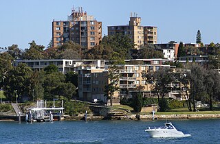
Drummoyne is a suburb in the Inner West of Sydney, in the state of New South Wales, Australia. Drummoyne is six kilometres west of the Sydney central business district and is the administrative centre for the local government area of the City of Canada Bay.

<span class="mw-page-title-main">Hen and Chicken Bay</span>

Hen and Chicken Bay is a bay on the Parramatta River, in the inner-west of Sydney, in the state of New South Wales, Australia. It lies approximately 8 kilometres due west of Sydney's central business district. It is surrounded by the suburbs of Abbotsford, Drummoyne, Wareemba, Five Dock, Canada Bay, Concord and Cabarita.

<span class="mw-page-title-main">Cabarita, New South Wales</span> Suburb of Sydney, New South Wales, Australia

Cabarita is a bayside suburb in the Inner West of Sydney, in the state of New South Wales, Australia. Cabarita is located 16 kilometres west of the Sydney central business district, in the local government area of the City of Canada Bay.

<span class="mw-page-title-main">Chiswick, New South Wales</span> Suburb of Sydney, New South Wales, Australia

Chiswick is a suburb in the Inner West of Sydney, in the state of New South Wales, Australia. It is located 9 kilometres west of the Sydney central business district in the local government area of the City of Canada Bay. Chiswick sits on the peninsula between Abbotsford Bay and Five Dock Bay, on the Parramatta River. It is surrounded by the suburbs of Abbotsford, Russell Lea and Drummoyne.

<span class="mw-page-title-main">Concord West, New South Wales</span> Suburb of Sydney, New South Wales, Australia

Concord West is a suburb on the periphery of Sydney's inner-west, in the state of New South Wales, Australia. Concord West is located 16 km west of the Sydney central business district, in the local government area of the City of Canada Bay. Concord is a separate suburb, to the east.

<span class="mw-page-title-main">Parramatta River ferry services</span>

Parramatta River ferry services connect suburbs along the Parramatta River in Sydney with Circular Quay by commuter ferry. The services are numbered F3 and form part of the Sydney Ferries network.

<span class="mw-page-title-main">Wentworth Point, New South Wales</span> Suburb of Sydney, New South Wales, Australia

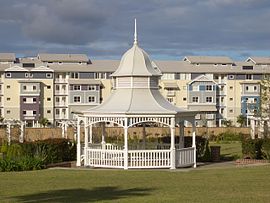
Wentworth Point is a suburb of Sydney, in the state of New South Wales, Australia. It is located 13 kilometres west of the Sydney central business district, on the eastern edge of the local government area of City of Parramatta. It is on the western shore of Homebush Bay on the southern side of the Parramatta River. Wentworth Point is usually regarded as part of the Greater Western Sydney region, including in administrative contexts, but it is also regarded as part of the Inner West region of Sydney in some contexts, especially commercial contexts.

References

  1. 1 2 Australian Bureau of Statistics (28 June 2022). "Breakfast Point (Suburbs and Localities)". 2021 Census QuickStats. Retrieved 4 August 2023. OOjs UI icon edit-ltr-progressive.svg
  2. Australian Suburb Guide: Sydney Inner West Archived 26 December 2012 at the Wayback Machine Retrieved 7 August 2013.
  3. Geographical Names Board - Breakfast Point
  4. Russell, Eric. Drummoyne: a western suburbs' history from 1794. Drummoyne, N.S.W.: Council of the Municipality of Drummoyne, Second Edition, 1982. ISBN   0-9599312-1-X.
  5. "Trove".
  6. Cobley, John (Compiler). Sydney Cove 1788 - in the Words of Australia's First Settlers : The True Story of a Nation's Birth. ISBN   0-207-15661-1.
  7. Broomham, R. 1986, Mortlake 1886-1986, AGL Pty. Ltd.
  8. "Local council stripped of planning controls". The Sydney Morning Herald. 1 September 2005. Retrieved 23 September 2005.

33°50′38″S151°06′46″E / 33.844°S 151.1129°E / -33.844; 151.1129