
Maitland is a city in the Lower Hunter Valley of New South Wales, Australia and the seat of Maitland City Council, situated on the Hunter River approximately 166 kilometres (103 mi) by road north of Sydney and 35 km (22 mi) north-west of Newcastle. It is on the New England Highway about 17 km (11 mi) from its start at Hexham.

Grafton is a city in the Northern Rivers region of the Australian state of New South Wales. It is located on the Clarence River, approximately 608 kilometres (378 mi) by road north-northeast of the state capital Sydney. The closest major cities, Brisbane and the Gold Coast, are located across the border in South-East Queensland. At June 2018 Grafton had a population of 19,078. The city is the largest settlement and administrative centre of the Clarence Valley Council local government area, which is home to over 50,000 people in all.

Muswellbrook is a town in the Upper Hunter Region of New South Wales, Australia, about 243 km (151 mi) north of Sydney and 127 km (79 mi) north-west of Newcastle.

Paterson is a small township in the lower Hunter Region of New South Wales, Australia. Located within Dungog Shire it is situated on the Paterson River. It is in the middle of what was once dairy, timber and citrus country and is now more significantly a feeder town for the nearby mining industry in the Upper Hunter and the city of Newcastle It was named after one of the first known Europeans in the area was Colonel William Paterson in 1801 surveyed the area beside the river.

Morpeth is a suburb of the city of Maitland in the Hunter Region of New South Wales, Australia. It is on the southern banks of the Hunter River at the border between the City of Maitland and Port Stephens Council LGAs. The major population centre, where almost all residents of the suburb reside, is the historical town of Morpeth which takes its name from Morpeth, Northumberland, near Newcastle upon Tyne, in England.
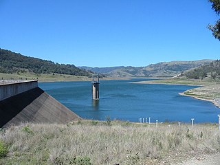
Glennies Creek Dam is a minor ungated concrete faced curved earth and rockfill embankment dam with an uncontrolled rock cut spillway across the Glennies Creek, upstream of Singleton, in the Hunter region of New South Wales, Australia. The dam's purpose includes flood mitigation, irrigation, water supply and conservation. The impounded reservoir is called Lake Saint Clair.

Seaham is a suburb of the Port Stephens local government area in the Hunter Region of New South Wales, Australia. It is located on the Williams River which flows into the Hunter River 14.6 km (9.1 mi) downstream from Seaham village at Raymond Terrace.

Kurri Kurri is a small town in the Hunter Region of New South Wales, Australia, in the Cessnock LGA. At the 2016 census, its population was 6,044. Kurri Kurri is the largest town in a group of towns and hamlets, including Stanford Merthyr, Pelaw Main, Weston, Abermain and Heddon Greta, called Kurri Kurri – Weston by the ABS. Its estimated population was 17,241 at 2016 census.
Yarramalong(cedar country) is a township and suburb of the Central Coast region of New South Wales, Australia, located 20 kilometres (12 mi) upstream from Wyong along the Wyong River. It is part of the Central Coast Council local government area.

East Maitland is a suburb in the City of Maitland, New South Wales, Australia. It is on the New England Highway and it has two railway stations, Victoria Street and East Maitland. Both stations are served by NSW TrainLink's Hunter Line. Hunter Valley Buses provides bus service.

Bungonia is a small town in the Southern Tablelands in New South Wales, Australia in Goulburn Mulwaree. At the 2016 census, Bungonia had a population of 367. The name of the town derives from an Aboriginal word meaning 'sandy creek'.

Majors Creek is a small village in the Southern Tablelands region of New South Wales, Australia. The nearest major town is Braidwood, 16 km (9.9 mi) to the north. At the 2016 census, the population of Majors Creek was 249.
Greigs Flat is a locality in the Bega Valley Shire of New South Wales, Australia. At the 2016 census, Greigs Flat had a population of 151.
Millfield is a town in the City of Cessnock municipality of New South Wales. It had a population of 1,006 as of the 2016 census.

The Williams River bridge, Clarence Town is a heritage-listed road bridge that carries Limeburners Creek Road across the Williams River located in Clarence Town, Dungog Shire, New South Wales, Australia. It was designed by the New South Wales Public Works Department and built by J. K. McKenzie. The property is owned by Roads and Maritime Services, an agency of the Government of New South Wales. It was added to the New South Wales State Heritage Register on 20 June 2000.
Mount George is a locality in the Mid-Coast Council of New South Wales. It had a population of 288 as of the 2016 census.
Glendon Brook is a locality in the Singleton Council region of New South Wales, Australia. It has also been known as Glendonbrook. It had a population of 266 as of the 2016 census.
Warkworth is a locality in the Singleton Council region of New South Wales, Australia. It had a population of 49 as of the 2016 census.

The Beckers Bridge over Webbers Creek is a heritage-listed timber truss road bridge that carries Main Road across Webbers Creek, located in Glendon Brook, Singleton Council, New South Wales, Australia. It was designed by Ernest de Burgh. The property is owned by Roads and Maritime Services, an agency of the Government of New South Wales. It was added to the New South Wales State Heritage Register on 20 June 2000.
The Glennies Creek Bridge is a heritage-listed road bridge that carries the Rixs Creek-Falbrook Road across the Glennies Creek, located at Middle Falbrook, in the Singleton Council local government area of New South Wales, Australia. The bridge was designed by Ernest de Burgh and built in 1902-03 by William Murphy and James Taylor. The property is owned by Roads and Maritime Services, an agency of the Government of New South Wales. The bridge was added to the New South Wales State Heritage Register on 20 June 2000.
