
New South Wales is a state on the east coast of Australia. It borders three other states, Queensland to the north, Victoria to the south, and South Australia to the west. Its coast borders the Coral and Tasman Seas to the east. The Australian Capital Territory is an enclave within the state. New South Wales' state capital is Sydney, which is also Australia's most populous city. In June 2020, the population of New South Wales was over 8.1 million, making it Australia's most populous state. Just under two-thirds of the state's population, 5.3 million, live in the Greater Sydney area. The demonym for inhabitants of New South Wales is New South Welshmen.
Young is a town in the South West Slopes region of New South Wales, Australia and the largest town in the Hilltops Region. The "Lambing Flat" Post Office opened on 1 March 1861 and was renamed "Young" in 1863.

Branxton is a town in the Hunter Region of New South Wales, Australia. Branxton is 171 kilometres (106 mi) north of Sydney via the Sydney-Newcastle Freeway and New England Highway. Branxton is located mostly in the City of Cessnock, but part of it is in Singleton Shire. It had a population of 1,991 at the 2016 census.

Hornsby Shire is a local government area situated in Northern Sydney, as well as parts of the Hills District, in the state of New South Wales, Australia. The shire stretches from the M2 Hills Motorway in the south to the Hawkesbury River town of Wisemans Ferry, some 53 kilometres (33 mi) to the north, making it the largest local government council in the Greater Sydney Metropolitan region by total area. As of the 2016 census the shire had an estimated population of 142,667.
The City of Bankstown was a local government area in the south-west region of Sydney, Australia, centred on the suburb of Bankstown, from 1895 to 2016. The last Mayor of the City of Bankstown Council was Clr Khal Asfour, a member of the Labor Party.

The Municipality of Hunter's Hill is a local government area on the Lower North Shore of Sydney, in the state of New South Wales, Australia. The municipality was first proclaimed in 1861, which includes the suburbs of Hunters Hill, Woolwich, Huntleys Point, Tarban, Henley and part of Gladesville.

The Lane Cove Council is a local government area located on the Lower North Shore of Sydney, New South Wales, Australia. The administrative seat of Lane Cove is located 10 kilometres (6.2 mi) north-west of the Sydney central business district.

The City of Ryde is a local government area in the Northern Sydney region, in the state of New South Wales, Australia. It was first established as the Municipal District of Ryde in 1870, became a municipality in 1906 and was proclaimed as the City of Ryde in 1992.

Woollahra Municipal Council is a local government area in the eastern suburbs of Sydney, in the state of New South Wales, Australia. Woollahra is bounded by Sydney Harbour in the north, Waverley Council in the east, Randwick City in the south and the City of Sydney in the west.

Ballina Shire is a local government area in the Northern Rivers region of New South Wales, Australia. The Shire was formed on 1 January 1977 by the amalgamation of the Municipality of Ballina and Tintenbar Shire. The Shire is located adjacent to the Tasman Sea and the Pacific Highway. The council seat is located in the town of Ballina. The population of the Ballina Shire area was 44,208 in June 2018.

Heatherbrae is a suburb of the Port Stephens local government area in the Hunter Region of New South Wales, Australia. The suburb lies to the east of the Hunter River and to the south of the town of Raymond Terrace. It is bisected by the Pacific Highway. At the 2016 census it had a population of 512. Most of the population lives to the west of the Pacific Highway in a housing subdivision while some residents live to the east of the highway in a semi-industrial area. Remaining residents live in rural and semi-rural areas adjacent to the highway and throughout the rest of the suburb. The Worimi people are the traditional owners of the Port Stephens area. In 2016 the median age of the population was 54. 80% were born in Australia, 2.6% New Zealand, 2.2% Pakistan, 2.0% England, 1% Germany and 0.8% China. In terms of religion, 26.1% were Anglican, 21.4% No Religion, 19.0% Catholic, 12.0% Not Stated and 4.5% Uniting Church. In terms of languages spoken other than English, 2.2% speak Urdu, 0.8% Tagalog, 0.6% Italian, 0.6% Serbo-Croatian/Yugoslavian and 0.6% Bengali.
Wyndham Estate was a leading winery in the Hunter Region, in New South Wales, Australia. It was founded by George Wyndham, who came to Australia in 1827 and planted a vineyard around his home, Dalwood, in the Hunter Valley. The winery won four gold medals, seven silver medals, and two bronze medals for its wines at the 1982 International Wine and Spirit Competition in England. The company was owned by Premium Wine Brands.

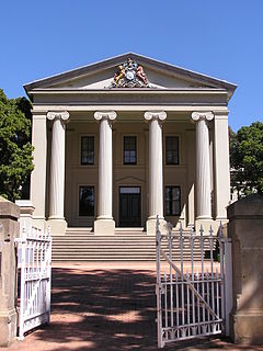
Dalwood House is a heritage-listed homestead and now house museum at Dalwood Road, Branxton, Singleton Council, New South Wales, Australia. It was built from 1829 to 1838 by George Wyndham. It sits in the grounds of the former Wyndham Estate winery. It was added to the New South Wales State Heritage Register on 2 April 1999.

Bayside Council is a local government in New South Wales, Australia. It is located in Sydney, around part of Botany Bay, 7 kilometres (4.3 mi) to 12 kilometres (7.5 mi) south of the CBD. It includes suburbs of South Sydney and the St George area separated by the Cooks River. It comprises an area of 50 square kilometres (19 sq mi) and as at the 2016 census had a population of 156,058.

Hubert Cyril Dalwood was a British sculptor. He was widely known as 'Nibs'.

North Talwood is a rural locality in the Goondiwindi Region, Queensland, Australia. In the 2016 census, North Talwood had a population of 169 people.

Talwood is a town in the rural locality of North Talwood in Goondiwindi Region, Queensland, Australia.
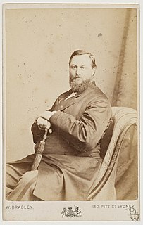
George Wyndham is a pioneering English - Australian winemarker famous for establishing the Wyndham wineries and his estate Dalwood in the Hunter Valley, where he planted Australia's first commercial Shiraz vineyard.
Dalwood is a village and civil parish in Devon, England. Dalwood may also refer to:
Dalwood is a locality in the Ballina Shire of New South Wales, Australia. It had a population of 234 as of the 2016 census.
