
Proserpine is a rural town and locality in the Whitsunday Region, Queensland, Australia. In the 2021 census, the locality of Proserpine had a population of 3,614 people.
Foxdale is a rural locality in the Whitsunday Region, Queensland, Australia. In the 2021 census, Foxdale had a population of 99 people.
Bloomsbury is a town and coastal locality in the Mackay Region, Queensland, Australia. In the 2021 census, the locality of Bloomsbury had a population of 539 people.
Toobanna is a rural town and locality in the Shire of Hinchinbrook, Queensland, Australia. In the 2021 census, the locality of Toobanna had a population of 276 people.
Mount Marlow is a rural locality in the Whitsunday Region, Queensland, Australia. In the 2021 census, Mount Marlow had a population of 161 people.
Conway is a locality in the Whitsunday Region, Queensland, Australia. In the 2021 census, Conway had a population of 202 people.
Gunyarra is a rural locality in the Whitsunday Region, Queensland, Australia. In the 2021 census, Gunyarra had a population of 30 people.

Flametree is a coastal locality in the Whitsunday Region, Queensland, Australia. In the 2021 census, Flametree had a population of 143 people.
Mandalay is a coastal locality in the Whitsunday Region, Queensland, Australia. In the 2021 census, Mandalay had a population of 338 people.

Jubilee Pocket is a residential locality in the Whitsunday Region, Queensland, Australia. In the 2021 census, Jubilee Pocket had a population of 2,047 people.
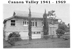
Cannon Valley is a semi-rural locality in the Whitsunday Region, Queensland, Australia. In the 2021 census, Cannon Valley had a population of 1,131 people.
Goorganga Plains is a coastal locality in the Whitsunday Region, Queensland, Australia. In the 2021 census, Goorganga Plains had "no people or a very low population".
Wilson Beach is a coastal locality in the Whitsunday Region, Queensland, Australia. In the 2021 census, Wilson Beach had a population of 68 people.
Conway Beach is a coastal locality in the Whitsunday Region, Queensland, Australia. In the 2021 census, Conway Beach had a population of 75 people.
Bilyana is a coastal locality in the Cassowary Coast Region, Queensland, Australia. In the 2021 census, Bilyana had a population of 190 people.
Brandy Creek is a rural locality in the Whitsunday Region, Queensland, Australia. In the 2021 census, Brandy Creek had a population of 114 people.
Mount Julian is a rural locality in the Whitsunday Region, Queensland, Australia. In the 2021 census, Mount Julian had a population of 477 people.
Thoopara is a rural locality in the Whitsunday Region, Queensland, Australia. In the 2021 census, Thoopara had a population of 52 people.
Preston is a rural locality in the Whitsunday Region, Queensland, Australia. In the 2021 census, Preston had a population of 346 people.
Proserpine–Shute Harbour Road is a continuous 34.3 kilometres (21.3 mi) road route in the Whitsunday local government area of Queensland, Australia. The route is designated as State Route 59. It is a state-controlled regional road.
