
Airlie Beach is a coastal locality and resort town in the Whitsunday Region of Queensland, Australia. In the 2021 census, Airlie Beach had a population of 1,312 people.

Shute Harbour is a coastal locality and harbour in the Whitsunday Region of Queensland, Australia. It has port facilities and transport options for people seeking to access the Whitsunday Islands and holiday destinations.

Proserpine is a rural town and locality in the Whitsunday Region, Queensland, Australia. In the 2021 census, the locality of Proserpine had a population of 3,614 people.

Cannonvale is a coastal locality in the Whitsunday Region, Queensland, Australia. In the 2021 census, Cannonvale had a population of 6,596 people.
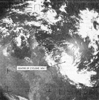
Severe Tropical Cyclone Ada was a small but intense tropical cyclone that severely impacted the Whitsunday Region of Queensland, Australia, in January 1970. It has been described as a defining event in the history of the Whitsunday Islands, and was the most damaging storm in the mainland town of Proserpine's history at the time. Forming over the far eastern Coral Sea in early January, the weather disturbance that would become Ada remained weak and disorganised for nearly two weeks as it slowly moved in a clockwise loop. Accelerating toward the southwest, the system was named Ada on 15 January. All observations of the fledgling cyclone were made remotely with weather satellite imagery until it passed over an automated weather station on 16 January. The extremely compact cyclone, with a gale radius of just 55 km (35 mi), intensified into a Category 3 severe tropical cyclone just before striking the Whitsunday Islands at 14:00 UTC on 17 January. At 18:30 UTC, Ada's eye crossed the coast at Shute Harbour. The cyclone made little inland progress before stalling northwest of Mackay and dissipating on 19 January.

Midge Point is a coastal town and rural locality in the Mackay Region, Queensland, Australia. In the 2021 census, the locality of Midge Point had a population of 435 people.
Mount Marlow is a rural locality in the Whitsunday Region, Queensland, Australia. In the 2021 census, Mount Marlow had a population of 161 people.

Cape Conway is a coastal locality in the Whitsunday Region, Queensland, Australia. In the 2021 census, Cape Conway had "no people or a very low population".
Mount Rooper is a coastal locality in the Whitsunday Region, Queensland, Australia. In the 2021 census, Mount Rooper had "no people or a very low population".

Flametree is a coastal locality in the Whitsunday Region, Queensland, Australia. In the 2021 census, Flametree had a population of 143 people.

Jubilee Pocket is a residential locality in the Whitsunday Region, Queensland, Australia. In the 2021 census, Jubilee Pocket had a population of 2,047 people.
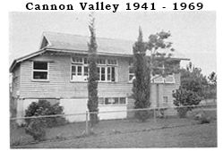
Cannon Valley is a semi-rural locality in the Whitsunday Region, Queensland, Australia. In the 2021 census, Cannon Valley had a population of 1,131 people.
Woodwark is a coastal locality in the Whitsunday Region, Queensland, Australia. In the 2021 census, Woodwark had a population of 559 people.

Cape Gloucester is a coastal locality in the Whitsunday Region, Queensland, Australia. In the 2021 census, Cape Gloucester had a population of 85 people.

Dingo Beach is a coastal rural locality in the Whitsunday Region, Queensland, Australia. In the 2021 census, Dingo Beach had a population of 159 people.

Hideaway Bay, also spelled Hydeaway Bay, is a coastal town and locality in the Whitsunday Region, Queensland, Australia. In the 2021 census, the locality of Hideaway Bay had a population of 232 people.
Brandy Creek is a rural locality in the Whitsunday Region, Queensland, Australia. In the 2021 census, Brandy Creek had a population of 114 people.
Preston is a rural locality in the Whitsunday Region, Queensland, Australia. In the 2021 census, Preston had a population of 346 people.
Whitsunday is a coastal town in the locality of Airlie Beach in the Whitsunday Region, Queensland, Australia.
Proserpine–Shute Harbour Road is a continuous 34.3 kilometres (21.3 mi) road route in the Whitsunday local government area of Queensland, Australia. The route is designated as State Route 59. It is a state-controlled regional road.
