Woodwark, Queensland

Last updated

Woodwark
Queensland
Australia Queensland location map.svg
Red pog.svg
Woodwark
Coordinates 20°14′58″S148°39′03″E / 20.2494°S 148.6508°E / -20.2494; 148.6508 (Woodwark (centre of locality))
Population559 (SAL 2021) [1]
Postcode(s) 4802
Area35.4 km2 (13.7 sq mi)
Time zone AEST (UTC+10:00)
Location
LGA(s) Whitsunday Region
State electorate(s) Whitsunday
Federal division(s) Dawson
Suburbs around Woodwark:
Coral Sea Coral Sea Coral Sea
Cape Gloucester Woodwark Coral Sea
Gregory River Riordanvale Cannonvale
Cannon Valley

Woodwark is a coastal locality in the Whitsunday Region, Queensland, Australia. [2] In the 2021 census, Woodwark had a population of 559 people. [3]

Contents

Geography

The waters of the Coral Sea form the northern boundary, part of the western, and most of the eastern. [4] There are three peninsula extending into the Coral Sea, with the following coastal features (clockwise):

The terrain is mountainous, varying from sea level to 450 metres (1,480 ft) above sea level, but there are no named peaks. [13]

The three peninsulas and the south-west of the locality are four sections of Dryander National Park. Apart from the protected areas, most of the land in the north, west, and centre of the locality is unused. The land use is primarily in the south-eastern part of the locality being residential with smaller suburban-sized blocks along the coast and larger rural residential blocks inland. In the south-east, there is some agriculture, a mix of horticulture and grazing on native vegetation. [14]

The coastal waters off Woodwark are part of the Great Barrier Reef Marine Park (Whitsunday Islands section), but are available for "general use" such as recreational boating, fishing, and diving. [15] [16]

History

The locality is named after Woodwark Bay, which was in turn named after George Smith Woodwark (mayor of King's Lynn) in 1886 by Lieutenant G.E. Richards of HMQS Paluma. [2] It is believed that the name was suggested by Lieutenant Alexander Leeper of Paluma as his family lived in King's Lynn. [17]

Demographics

In the 2016 census, Woodwark had a population of 374 people. [18]

In the 2021 census, Woodwark had a population of 559 people. [3]

Education

There are no schools in Woodwark. The nearest government primary school is Cannonvale State School in neighbouring Cannonvale to the south-east. The nearest government secondary school is Proserpine State High School in Proserpine to the south-west. [19]

Related Research Articles

<span class="mw-page-title-main">Bowen, Queensland</span> Town in Queensland, Australia

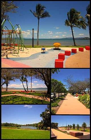
Bowen is a coastal town and locality in the Whitsunday Region, Queensland, Australia. In the 2016 census, the locality of Bowen had a population of 10,377 people.

<span class="mw-page-title-main">Airlie Beach, Queensland</span> Suburb of Whitsunday Region, Queensland, Australia

Airlie Beach is a coastal locality and resort town in the Whitsunday Region of Queensland, Australia. In the 2016 census, Airlie Beach had a population of 1,208 people.

<span class="mw-page-title-main">Shute Harbour</span> Suburb of Whitsunday Region, Queensland, Australia

Shute Harbour is a coastal locality and harbour in the Whitsunday Region of Queensland, Australia. It has port facilities and transport options for people seeking to access the Whitsunday Islands and holiday destinations.

<span class="mw-page-title-main">Mount Coolon, Queensland</span> Suburb of Whitsunday Region, Queensland, Australia

Mount Coolon is a rural town and locality in the Whitsunday Region, Queensland, Australia. In the 2016 census, the locality of Mount Coolon had a population of 64 people.

<span class="mw-page-title-main">Springlands, Queensland</span> Suburb of Whitsunday Region, Queensland, Australia

Springlands is a rural locality in the Whitsunday Region, Queensland, Australia.

<span class="mw-page-title-main">Cannonvale, Queensland</span> Suburb of Whitsunday Region, Queensland, Australia

Cannonvale is a coastal locality and town in the Whitsunday Region, Queensland, Australia. In the 2016 census Cannonvale had a population of 5,716 people.

<span class="mw-page-title-main">Midge Point, Queensland</span> Town in Queensland, Australia

Midge Point is a coastal town and rural locality in the Mackay Region, Queensland, Australia. In the 2016 census, the locality of Midge Point had a population of 464 people.

<span class="mw-page-title-main">Guthalungra, Queensland</span> Town in Queensland, Australia

Guthalungra is a rural town and coastal locality in the Whitsunday Region, Queensland, Australia. In the 2016 census, the locality of Guthalungra had a population of 112 people.

Laguna Quays is a coastal locality in the Mackay Region, Queensland, Australia. In the 2021 census, Laguna Quays had a population of 89 people.

<span class="mw-page-title-main">Cape Conway, Queensland</span> Suburb of Whitsunday Region, Queensland, Australia

Cape Conway is a coastal locality in the Whitsunday Region, Queensland, Australia. In the 2021 census, Cape Conway had "no people or a very low population".

Whitsundays is an island group locality in the Whitsunday Region, Queensland, Australia. It mostly consists of the Whitsunday Group of islands off the Queensland east coast in the Coral Sea, a mix of inhabited and uninhabited islands. In the 2016 census, Whitsundays had a population of 2,269 people.

<span class="mw-page-title-main">Flametree, Queensland</span> Suburb of Whitsunday Region, Queensland, Australia

Flametree is a coastal locality in the Whitsunday Region, Queensland, Australia. In the 2021 census, Flametree had a population of 143 people.

Mandalay is a coastal locality in the Whitsunday Region, Queensland, Australia. In the 2021 census, Mandalay had a population of 338 people.

<span class="mw-page-title-main">Jubilee Pocket, Queensland</span> Suburb of Whitsunday Region, Queensland, Australia

Jubilee Pocket is a residential locality in the Whitsunday Region, Queensland, Australia. In the 2021 census, Jubilee Pocket had a population of 2,047 people.

<span class="mw-page-title-main">Cannon Valley, Queensland</span> Suburb of Whitsunday Region, Queensland, Australia

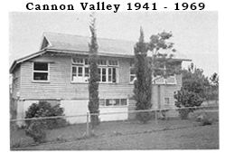
Cannon Valley is a semi-rural locality in the Whitsunday Region, Queensland, Australia. In the 2021 census, Cannon Valley had a population of 1,131 people.

<span class="mw-page-title-main">Cape Gloucester, Queensland</span> Suburb of Whitsunday Region, Queensland, Australia

Cape Gloucester is a coastal locality in the Whitsunday Region, Queensland, Australia. In the 2021 census, Cape Gloucester had a population of 85 people.

<span class="mw-page-title-main">Dingo Beach, Queensland</span> Suburb of Whitsunday Region, Queensland, Australia

Dingo Beach is a coastal rural locality in the Whitsunday Region, Queensland, Australia. In the 2016 census, Dingo Beach had a population of 169 people.

<span class="mw-page-title-main">Hideaway Bay, Queensland</span> Town in Queensland, Australia

Hideaway Bay, also spelled Hydeaway Bay, is a coastal town and locality in the Whitsunday Region, Queensland, Australia. In the 2021 census, the locality of Hideaway Bay had a population of 232 people.

Preston is a rural locality in the Whitsunday Region, Queensland, Australia. In the 2021 census, Preston had a population of 346 people.

Heronvale is a coastal town in the Whitsunday Region, Queensland, Australia. It is within the locality of Bowen.

References

  1. Australian Bureau of Statistics (28 June 2022). "Woodwark (suburb and locality)". Australian Census 2021 QuickStats. Retrieved 28 June 2022.  OOjs UI icon edit-ltr-progressive.svg
  2. 1 2 "Woodwark – locality in Whitsunday Region (entry 46906)". Queensland Place Names. Queensland Government . Retrieved 30 May 2019.
  3. 1 2 Australian Bureau of Statistics (28 June 2022). "Woodwark (SAL)". 2021 Census QuickStats. Retrieved 28 February 2023. OOjs UI icon edit-ltr-progressive.svg
  4. Google (20 August 2021). "Woodwark, Queensland" (Map). Google Maps . Google. Retrieved 20 August 2021.
  5. "Double Bay – bay in the Whitsunday Region (entry 38010)". Queensland Place Names. Queensland Government . Retrieved 18 March 2024.
  6. 1 2 3 "Bays - Queensland". Queensland Open Data. Queensland Government. 12 November 2020. Archived from the original on 25 November 2020. Retrieved 25 November 2020.
  7. "Datum Rock – rock in the Whitsunday Region (entry 9407)". Queensland Place Names. Queensland Government . Retrieved 18 March 2024.
  8. "Datum Rock – rock in Whitsunday Regional (entry 9407)". Queensland Place Names. Queensland Government . Retrieved 2 October 2023.
  9. "Woodwark Bay – bay in the Whitsunday Region (entry 38010)". Queensland Place Names. Queensland Government . Retrieved 18 March 2024.
  10. "Grimstone Point – point in the Whitsunday Region (entry 14898)". Queensland Place Names. Queensland Government . Retrieved 18 March 2024.
  11. "Bluff Point – point in the Whitsunday Region (entry 3340)". Queensland Place Names. Queensland Government . Retrieved 18 March 2024.
  12. "Pioneer Bay – bay in the Whitsunday Region (entry 26969)". Queensland Place Names. Queensland Government . Retrieved 18 March 2023.
  13. "Layers: Locality; Mountains and ranges; Contours; Watercourses". Queensland Globe. Queensland Government. Archived from the original on 19 December 2017. Retrieved 18 March 2024.
  14. "Layers: Locality; Protected areas and forests; Land use; Land parcel". Queensland Globe. Queensland Government. Archived from the original on 19 December 2017. Retrieved 18 March 2024.
  15. "Layers: Locality; Great Barrier Reef coast zoning". Queensland Globe. Queensland Government. Archived from the original on 19 December 2017. Retrieved 21 March 2024.
  16. "Interpreting zones". Great Barrier Reef Marine Park Authority . Archived from the original on 8 March 2024. Retrieved 22 March 2024.
  17. "Woodwark Bay – bay in the Whitsunday Region (entry 38010)". Queensland Place Names. Queensland Government . Retrieved 2 June 2019.
  18. Australian Bureau of Statistics (27 June 2017). "Woodwark (SSC)". 2016 Census QuickStats. Retrieved 20 October 2018. OOjs UI icon edit-ltr-progressive.svg
  19. "Layers: Locality; Schools and school catchments". Queensland Globe. Queensland Government. Archived from the original on 19 December 2017. Retrieved 21 March 2024.