Conway, Queensland

Last updated

Conway
Queensland
Australia Queensland location map.svg
Red pog.svg
Conway
Coordinates 20°27′28″S148°42′51″E / 20.4577°S 148.7141°E / -20.4577; 148.7141 (Conway (centre of locality))
Population202 (SAL 2021) [1]
Postcode(s) 4800
Area18.0 km2 (6.9 sq mi)
Time zone AEST (UTC+10:00)
Location
LGA(s) Whitsunday Region
State electorate(s) Whitsunday
Federal division(s) Dawson
Suburbs around Conway:
Preston Palm Grove Cape Conway
Goorganga Plains Conway Cape Conway
Goorganga Plains Wilson Beach Conway Beach

Conway is a locality in the Whitsunday Region, Queensland, Australia. [2] In the 2021 census, Conway had a population of 202 people. [3]

Contents

Geography

Conway is bounded on the north-west by Serpentine Creek and to the west and south-west by the Proserpine River. Conway Road runs along the western part of the locality which is lower flatter land; the residential and farming land is in that area. The eastern part of the locality is more mountainous and undeveloped. [4]

History

The locality name derives from Cape Conway, which was named on 3 June 1770 by Lieutenant James Cook on the HM Bark Endeavour after Henry Seymour Conway, the Secretary of State for the Southern Department from 1765 to 1766 and Northern Department from 1766 to 1768. [2]

Demographics

In the 2016 census, Conway had a population of 194 people. [5]

In the 2021 census, Conway had a population of 202 people. [3]

Education

There are no schools in Conway. The nearest government primary and secondary schools are Proserpine State School and Proserpine State High School, both in Proserpine to the north-west. [4]

Amenities

There is a boat ramp and floating walkway at Conway Road into the Prosperine River ( 20°27′07″S148°41′58″E / 20.4519°S 148.6994°E / -20.4519; 148.6994 (Conway Road boat ramp) ). It is managed by the Whitsunday Regional Council. [6]

Related Research Articles

<span class="mw-page-title-main">Airlie Beach, Queensland</span> Suburb of Whitsunday Region, Queensland, Australia

Airlie Beach is a coastal locality and resort town in the Whitsunday Region of Queensland, Australia. In the 2016 census, Airlie Beach had a population of 1,208 people.

<span class="mw-page-title-main">Shute Harbour</span> Suburb of Whitsunday Region, Queensland, Australia

Shute Harbour is a coastal locality and harbour in the Whitsunday Region of Queensland, Australia. In the 2016 census, Shute Harbour had a population of 122 people.

<span class="mw-page-title-main">Proserpine, Queensland</span> Town in Queensland, Australia

Proserpine is a rural town and locality in the Whitsunday Region, Queensland, Australia. In the 2021 census, the locality of Proserpine had a population of 3,614 people.

Foxdale is a rural locality in the Whitsunday Region, Queensland, Australia. In the 2016 census Foxdale had a population of 127 people.

<span class="mw-page-title-main">Cannonvale, Queensland</span> Suburb of Whitsunday Region, Queensland, Australia

Cannonvale is a coastal locality and resort town in the Whitsunday Region, Queensland, Australia. In the 2016 census Cannonvale had a population of 5,716 people.

<span class="mw-page-title-main">Midge Point, Queensland</span> Town in Queensland, Australia

Midge Point is a coastal town and rural locality in the Mackay Region, Queensland, Australia. In the 2016 census, the locality of Midge Point had a population of 464 people.

Dittmer is a rural town and locality in the Whitsunday Region, Queensland, Australia. In the 2016 census, the locality of Dittmer had a population of 79 people.

Mount Marlow is a rural locality in the Whitsunday Region, Queensland, Australia. In the 2016 census Mount Marlow had a population of 132 people.

<span class="mw-page-title-main">Cape Conway, Queensland</span> Suburb of Whitsunday Region, Queensland, Australia

Cape Conway is a coastal locality in the Whitsunday Region, Queensland, Australia. In the 2021 census, Cape Conway had "no people or a very low population".

Gunyarra is a rural locality in the Whitsunday Region, Queensland, Australia. In the 2016 census, Gunyarra had a population of 16 people.

<span class="mw-page-title-main">Flametree, Queensland</span> Suburb of Whitsunday Region, Queensland, Australia

Flametree is a coastal locality in the Whitsunday Region, Queensland, Australia. In the 2016 census, Flametree had a population of 122 people.

Mandalay is a coastal locality in the Whitsunday Region, Queensland, Australia. In the 2016 census, Mandalay had a population of 337 people.

<span class="mw-page-title-main">Cannon Valley, Queensland</span> Suburb of Whitsunday Region, Queensland, Australia

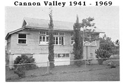
Cannon Valley is a semi-rural locality in the Whitsunday Region, Queensland, Australia. In the 2021 census, Cannon Valley had a population of 1,131 people.

Wilson Beach is a coastal locality in the Whitsunday Region, Queensland, Australia. In the 2021 census, Wilson Beach had a population of 68 people.

<span class="mw-page-title-main">Conway Beach, Queensland</span> Suburb of Whitsunday Region, Queensland, Australia

Conway Beach is a coastal locality in the Whitsunday Region, Queensland, Australia. In the 2021 census, Conway Beach had a population of 75 people.

Cape Gloucester is a coastal locality in the Whitsunday Region, Queensland, Australia. In the 2021 census, Cape Gloucester had a population of 85 people.

<span class="mw-page-title-main">Dingo Beach, Queensland</span> Suburb of Whitsunday Region, Queensland, Australia

Dingo Beach is a coastal rural locality in the Whitsunday Region, Queensland, Australia. In the 2016 census, Dingo Beach had a population of 169 people.

<span class="mw-page-title-main">Hideaway Bay, Queensland</span> Town in Queensland, Australia

Hideaway Bay, also spelled Hydeaway Bay, is a coastal town and locality in the Whitsunday Region, Queensland, Australia. In the 2021 census, the locality of Hideaway Bay had a population of 232 people.

Bogie is a rural locality in the Whitsunday Region, Queensland, Australia. In the 2021 census, Bogie had a population of 207 people.

Preston is a rural locality in the Whitsunday Region, Queensland, Australia. In the 2016 census, Preston had a population of 296 people. The town of Bonavista is within the south of the locality.

References

  1. Australian Bureau of Statistics (28 June 2022). "Conway (Suburb and Locality)". Australian Census 2021 QuickStats. Retrieved 28 June 2022.  OOjs UI icon edit-ltr-progressive.svg
  2. 1 2 "Conway – locality in Whitsunday Region (entry 46860)". Queensland Place Names. Queensland Government . Retrieved 31 December 2017.
  3. 1 2 Australian Bureau of Statistics (28 June 2022). "Conway (SAL)". 2021 Census QuickStats. Retrieved 28 February 2023. OOjs UI icon edit-ltr-progressive.svg
  4. 1 2 "Queensland Globe". State of Queensland . Retrieved 31 August 2023.
  5. Australian Bureau of Statistics (27 June 2017). "Conway (SSC)". 2016 Census QuickStats. Retrieved 20 October 2018. OOjs UI icon edit-ltr-progressive.svg
  6. "Recreational Boating Facilities Queensland". Queensland Open Data. Queensland Government. 12 November 2020. Archived from the original on 22 November 2020. Retrieved 22 November 2020.