Enoggera Creek

Last updated

Enoggera
Enoggera Creek at the The Gap.jpg
Enoggera Creek at The Gap, 2010
Location
Country Australia
State Queensland
Region South East Queensland
City Brisbane
Physical characteristics
Source Enoggera Reservoir
  location D'Aguilar Range
  coordinates 27°24′06″S152°48′21″E / 27.4017°S 152.8059°E / -27.4017; 152.8059 (Enoggera Creek (source))
Mouth Breakfast Creek
  location
railway bridge at the intersection of the suburbs of Windsor, Albion and Bowen Hills
  coordinates
27°26′01″S153°02′23″E / 27.4336°S 153.0397°E / -27.4336; 153.0397 (Enoggera Creek (mouth))
Basin features
Tributaries 
  right Ithaca Creek

Enoggera Creek is a creek which flows through the City of Brisbane in South-East Queensland, Australia. [1]

Contents

Geography

Enoggera Creek rises in the suburb of Enoggera Reservoir on the D'Aguilar Range and flows into the Brisbane River (becoming Breakfast Creek in the final stage). The creek's headwaters form on the southern slopes of Mount Nebo in Brisbane Forest Park.

Within the suburb of Enoggera Reservoir, the creek is dammed by Enoggera Dam ( ( 27°26′50″S152°55′37″E / 27.4473°S 152.927°E / -27.4473; 152.927 (Enoggera Dam) ). After which, it meanders in a south-easterly direction, leaving the undisturbed parkland and flowing through the Brisbane suburbs of The Gap, Ashgrove (where it separates the neighbourhood of St Johns Wood from the rest of the suburb), Alderley, Newmarket, Red Hill, Kelvin Grove, Wilston, Herston, Windsor and Bowen Hills. [2]

Ithaca Creek flows from Mount Coot-tha and joins Enoggera Creek from the south at the intersection of the suburbs of Ashgrove, Red Hill and Newmarket ( 27°26′43″S153°00′07″E / 27.4453°S 153.0019°E / -27.4453; 153.0019 (Ithaca Creek (mouth)) ). [2] [3]

The creek officially becomes Breakfast Creek from the railway bridge at the intersection of the suburbs of Windsor, Bowen Hills, and Albion, which then flows into the Brisbane River. [1]

The creek is being rehabilitated and restored by the community organisation called Save Our Waterways Now. [4]

History

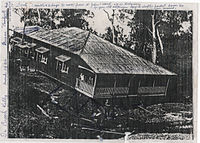
Significant flooding occurred along the creek during the major floods, including 1893 and 1974 Brisbane flood resulting in a number of houses being washed away.[ citation needed ]

See also

Related Research Articles

<span class="mw-page-title-main">Albion, Queensland</span> Suburb of Brisbane, Queensland, Australia

Albion is an inner north-eastern suburb in the City of Brisbane, Queensland, Australia. In the 2016 census, Albion had a population of 2,296 people.

<span class="mw-page-title-main">St Lucia, Queensland</span> Suburb of Brisbane, Queensland, Australia

St Lucia is a riverside suburb in the City of Brisbane, Queensland, Australia. In the 2016 census St Lucia had a population of 12,574 people. The University of Queensland is the main attraction of St Lucia, with the university, and residential colleges covering a large proportion of the suburb. St Lucia is home to a diverse range of people and families. Typically, the student population of St Lucia is high, especially in dwellings in the immediate vicinity of the university, but the suburb is also home to wealthy professionals and families.

The Division of Brisbane is an Australian electoral division in the state of Queensland.

<span class="mw-page-title-main">Alderley, Queensland</span> Suburb of Brisbane, Queensland, Australia

Alderley is a northern suburb in the City of Brisbane, Queensland, Australia. In the 2016 census, Alderley had a population of 6,117 people.

<span class="mw-page-title-main">The Gap, Queensland</span> Suburb of Brisbane, Queensland, Australia

The Gap is a north-western suburb in the City of Brisbane, Queensland, Australia. In the 2021 census, The Gap had a population of 17,318 people.

<span class="mw-page-title-main">Windsor, Queensland</span> Suburb of Brisbane, Queensland, Australia

Windsor is an inner northern suburb in the City of Brisbane, Queensland, Australia. In the 2016 census, Windsor had a population of 7,013 people.

<span class="mw-page-title-main">Kelvin Grove, Queensland</span> Suburb of Brisbane, Queensland, Australia

Kelvin Grove is an inner northern suburb in the City of Brisbane, Queensland, Australia. In the 2016 census, Kelvin Grove had a population of 7,927 people.

<span class="mw-page-title-main">Taylor Range</span> Mountain range in Queensland, Australia

The Taylor Range or Herbert Taylor Range is a mountain range on the western edge of Brisbane, Queensland, Australia. It was first named The Glenmorrison Range by John Oxley during his exploration of the area in January 1824. In 1828, the colonial botanist Charles Fraser, whilst looking at the range from the Ipswich area, noted the bearings as Sir Herbert Taylor’s Range from which the current name derived.

<span class="mw-page-title-main">Ashgrove, Queensland</span> Suburb of Brisbane, Queensland, Australia

Ashgrove is a suburb in the City of Brisbane, Queensland, Australia. In the 2021 census, Ashgrove had a population of 13,716 people.

<span class="mw-page-title-main">Gaythorne, Queensland</span> Suburb of Brisbane, Queensland, Australia

Gaythorne is a suburb in the City of Brisbane, Queensland, Australia. In the 2016 census, Gaythorne had a population of 3,023 people.

Newmarket is a north-west suburb in the City of Brisbane, Queensland, Australia. In the 2016 census, Newmarket had a population of 4,979 people.

<span class="mw-page-title-main">Red Hill, Queensland</span> Suburb of Brisbane, Queensland, Australia

Red Hill is an inner northern suburb in the City of Brisbane, Queensland, Australia. In the 2016 census, Red Hill had a population of 5,560 people.

<span class="mw-page-title-main">Enoggera, Queensland</span> Suburb of Brisbane, Queensland, Australia

Enoggera is a north-western suburb in the City of Brisbane, Queensland, Australia. It is home to the Gallipoli Barracks.

<span class="mw-page-title-main">Enoggera Reservoir, Queensland</span> Suburb of Brisbane, Queensland, Australia

Enoggera Reservoir is an outer north-western suburb in the City of Brisbane, Queensland, Australia. In the 2016 census, Enoggera Reservoir had a population of 25 people.

<span class="mw-page-title-main">Town of Ithaca</span>

The Town of Ithaca is a former local government area of Queensland, Australia, located in inner western Brisbane.

<span class="mw-page-title-main">Enoggera Dam</span> Dam in South East Queensland

The Enoggera Dam is a heritage-listed dam, which is located within the outer, western suburb of Enoggera Reservoir, in Brisbane, Queensland, Australia.

<span class="mw-page-title-main">Moggill Creek</span> River in Queensland, Australia

Moggill Creek is a creek in Brisbane, the largest city in Queensland, Australia. The creek rises on the Taylor Range and runs in a south-easterly direction from the southern edge of Brisbane Forest Park in Kholo and Pullenvale, flowing through Upper Brookfield, Brookfield and joining the Brisbane River at Kenmore. Before entering the Brisbane River the creek is crossed by Moggill Road and winds through Rafting Ground Reserve.

Ithaca is a former suburb of Brisbane, Australia. Since 1975, Ithaca has been designated a neighbourhood within the suburb of Red Hill in Brisbane.

<span class="mw-page-title-main">Ithaca Creek</span> River in Queensland, Australia

Ithaca Creek is a waterway in the Enoggera Creek catchment, in the western suburbs of Brisbane, Queensland, Australia. It arises in the Taylor Range at the Mount Coot-tha forest with two streams, one arising at J C Slaughter Falls, the other and stronger source being Simpson Falls, the western branch.

<span class="mw-page-title-main">Waterworks Road</span> Arterial road in Brisbane, Australia

Waterworks Road is an 8.5 km (5.3 mi) arterial road in Brisbane, Queensland, Australia. It is currently signed as State Route 31 for its entire length. Waterworks Road transports traffic between the Brisbane central business district and western suburbs such as Red Hill, Ashgrove and The Gap.

References

  1. 1 2 "Enoggera Creek – watercourse in City of Brisbane (entry 11783)". Queensland Place Names. Queensland Government . Retrieved 4 July 2020.
  2. 1 2 "Queensland Globe". State of Queensland . Retrieved 3 July 2020.
  3. "Ithaca Creek – watercourse in the City of Brisbane (entry 16888)". Queensland Place Names. Queensland Government . Retrieved 4 July 2020.
  4. Save Our Waterways Now: About Us

Commons-logo.svg Media related to Enoggera Creek at Wikimedia Commons