
Severe storms in Australia refers to the storms, including cyclones, which have caused severe damage in Australia.
The 1999–2000 Australian region cyclone season was a slightly above average tropical cyclone season. It ran from 1 November 1999 to 30 April 2000. The regional tropical cyclone operational plan also defines a "tropical cyclone year" separately from a "tropical cyclone season", with the "tropical cyclone year" for this season lasting from 1 July 1999 to 30 June 2000.

In 1893 the Indooroopilly Railway Bridge and Albert Railway Bridge, where washed away down the Brisbane River and the Sand bars All the existing bridges in 1893 with high flood level Waters being as high as underneath the bridge on top of the cars underneath the road but pretty much about 10 m up towards Oxley Road on the low line corners and then eventually went up to the bike path An eventually that was washed in the Brisbane River And it took 100 years to clean up because the Riverwalk that’s there today is now also gone if it was there in the first place but however the roads would’ve also been gone as well on the other side of Indooroopilly just like In 1974 but not as bad that area was ravaged by floods even the back of Chelmer streets were destroyed As well up to as far as almost at the top of the cars on the bridge at the intersection, but however, if all suburbs in Brisbane all underwater like most of them that means it would’ve been out to Ipswich but even higher in some areas even Thomas Street Sherwood was underwater too up to many people‘s houses but however on the Gold Coast it was enormous and after that it was a huge cleanup

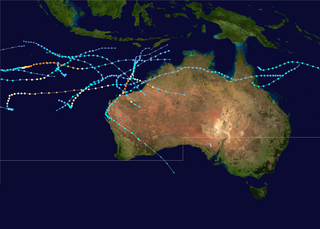
The 2010–11 Australian region cyclone season was a near average tropical cyclone season, with eleven tropical cyclones forming compared to an average of 12. The season was also the costliest recorded in the Australian region basin, with a total of $3.62 billion in damages, mostly from the destructive Cyclone Yasi. The season began on 1 November 2010 and ended on 30 April 2011, although the first tropical cyclone formed on 28 October. The Australian region is defined as being to the south of the equator, between the 90th meridian east and 160th meridian east. Tropical cyclones in this area are monitored by five Tropical Cyclone Warning Centres (TCWC's): Jakarta, Port Moresby, Perth, Darwin, and Brisbane, each of which have the power to name a tropical cyclone. The TCWC's in Perth, Darwin, and Brisbane are run by the Bureau of Meteorology, who designate significant tropical lows with a number and the U suffix. The Joint Typhoon Warning Center also issues unofficial warnings for the region, designating significant tropical cyclones with the "S" suffix when they form west of 135°E, and the "P" suffix when they form east of 135°E.

Severe Tropical Cyclone Rona and Severe Tropical Cyclone Frank were a pair of tropical cyclones that affected Queensland and New Caledonia during the 1998–99 Australian region cyclone season and the 1998–99 South Pacific cyclone season. Rona originated from a low that developed on 9 February about 225 km (140 mi) to the northeast of Cairns. Over the next couple of days, the low slowly developed further before it was upgraded into a Category 1 cyclone on the Australian intensity scale by the Australian Bureau of Meteorology on 10 February as it started to move towards the southwest. Subsequently, Rona rapidly intensified just before making landfall near the Cape York Peninsula. While the low-level circulation became difficult to locate on 12 February, the upper-level circulation eventually emerged into the Coral Sea and later regenerated into Tropical Cyclone Frank. The system rapidly intensified before making landfall on New Caledonia as a Category 2 cyclone on the Saffir-Simpson Hurricane Scale in the early morning hours of 20 February. Frank was re-classified as an extratropical cyclone the next day.

The 1973–74 Australian region cyclone season was the third most active tropical cyclone season in the Australian Region.

The geography of Queensland in the north-east of Australia, is varied. It includes tropical islands, sandy beaches, flat river plains that flood after monsoon rains, tracts of rough, elevated terrain, dry deserts, rich agricultural belts and densely populated urban areas.

Severe Tropical Cyclone Aivu was a powerful late-season tropical cyclone that caused extensive damage across parts of Queensland, Australia in April 1989.

A series of floods hit Queensland, Australia, beginning in December 2010. The floods forced the evacuation of thousands of people from towns and cities. At least 90 towns and over 200,000 people were affected. Damage initially was estimated at A$1 billion before it was raised to $2.38 billion. The estimated reduction in Australia's GDP is about A$30 billion. As of March 2012, there were 33 deaths attributed to the floods, with a further three people still missing.

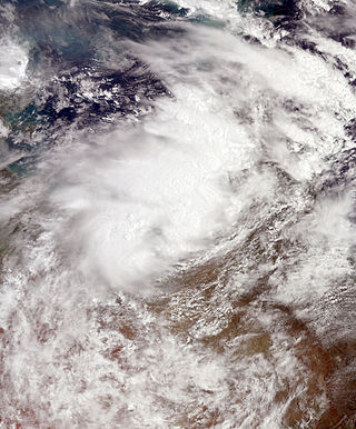
Severe Tropical Cyclone Yasi was a powerful and destructive tropical cyclone that made landfall in northern Queensland, Australia in early 2011, causing major damage to the affected areas. Originating as a tropical low near Fiji on 26 January, the system intensified to tropical cyclone status during the evening of 30 January. Yasi deepened rapidly over the next 24 hours, and was classified as a Category 3 cyclone at about 5 PM AEST on 31 January 2011. Late on 1 February, the cyclone strengthened to a Category 4 system; then, early on 2 February, the cyclone intensified into a Category 5 Severe Tropical Cyclone. The system had a well-defined eye and continued to track west-southwestward, maintaining a central pressure of 930 hPa and a Dvorak intensity of T6.5 into the evening.
The 2013–14 Australian region cyclone season was a slightly below-average tropical cyclone season, with 10 tropical cyclones occurring within the Australian region. It officially started on 1 November 2013, and ended on 30 April 2014. The regional tropical cyclone operational plan defines a "tropical cyclone year" separately from a "tropical cyclone season"; the "tropical cyclone year" began on 1 July 2013 and ended on 30 June 2014.

Tropical Cyclone Oswald was a tropical cyclone that passed over parts of Queensland and New South Wales, Australia over a number of days, causing widespread impact including severe storms, flooding, and water spouts. Coastal regions of Queensland were the most impacted with Mundubbera, Eidsvold, Gayndah and Bundaberg in the Wide Bay–Burnett hit severely. In many places the rainfall total for January set new records. Across the affected region, damage from severe weather and flooding amounted to at least A$2.4 billion.

Australian east coast lows are extratropical cyclones or low-pressure systems on the coast of southeastern Australia that may be caused by both mid-latitude and tropical influences over a variety of levels in the atmosphere. These storms should not be confused with Australian region tropical cyclones which typically affect the northern half of the continent.

Severe Tropical Cyclone Joy struck Australia in late 1990, causing the third highest floods on record in Rockhampton, Queensland. This cyclone began as a weak tropical low near the Solomon Islands, and initially moved westward. On 18 December, it was named Joy, becoming the 2nd named storm of the 1990–91 Australian region cyclone season. After turning southwest, Joy developed a well-defined eye and strengthened to maximum sustained winds of 165 km/h (103 mph) while approaching Cairns in Far North Queensland. Brushing the city with strong winds, the cyclone soon weakened and turned southeast. Joy later curved back southwest, making landfall near Townsville, Queensland on 26 December. It dissipated the next day; remnant moisture continued as torrential rainfall over Queensland for two weeks.

Severe Tropical Cyclone Winifred was the worst tropical cyclone to make landfall in northern Queensland and the first since Althea in 1971 to inflict significant damage on the northeastern coast of Australia. The sixth named storm of the 1985–86 Australian region cyclone season, Winifred originated as a tropical low north of Cairns, Queensland on 27 January 1986. Slowly organizing, the system was recognized as a tropical cyclone after gaining tropical characteristics on 30 January, christened with the name Winifred the same day. Meandering southward, the cyclone began to curve southeastward that evening before suddenly turning toward the coast, southwestward, on 31 January, steadily intensifying in that time. By the time it came ashore near Silkwood, Queensland at 0445 UTC on 1 February, it was producing Category 3-force winds on the Australian tropical cyclone intensity scale and a minimum atmospheric pressure of 957 mbar (28.38 inHg). Weakening as it drifted inland, Winifred persisted as a tropical depression for another five days after landfall before finally dissipating on 5 February.
Tropical Low Fletcher was a weak system that produced torrential rains over parts of Queensland, Australia in February 2014. Originating as tropical low over the Timor Sea on 30 January, Fletcher quickly became an organised system as it moved over the Top End region of the Northern Territory. Once over the Gulf of Carpentaria on 2 February, deep convection formed near its center and the following day it became a tropical cyclone. With peak winds estimated at 65 km/h (40 mph), the storm made landfall in Queensland before weakening to a low. Over the following week, the system's movement became slow and erratic. Executing three loops, the former cyclone meandered over the southeastern Gulf of Carpentaria before accelerating southwest and later west. Fletcher was last noted on 12 February over the Alice Springs District in the Northern Territory.

Severe Tropical Cyclone Peter was at the time, the wettest tropical cyclone on record in Australia, until it was surpassed by Cyclone Jasper in 2023. The third system and first severe tropical cyclone of the 1978–79 season, Peter developed on 29 December from a weak low pressure area over the Gulf of Carpentaria. Peter moved southeastward and deepened while brushing Arnhem Land. Initially a tropical low, it strengthened into a Category 1 cyclone by 12:00 UTC on 29 December. Peter intensified further on 30 December and became a Category 2 cyclone. On the following day, the cyclone peaked with maximum sustained winds of 110 km/h (70 mph). Peter weakened to a Category 1 cyclone before making landfall near the mouth of the Edward River in Queensland. While crossing the Cape York Peninsula, the storm weakened slowly. After reaching Pacific Ocean near Cooktown, the storm decelerated and meandered offshore, but dissipated just offshore on 4 January.

Severe Tropical Cyclone Dinah was an intense tropical cyclone that impacted the southern coasts of Queensland and New South Wales, causing floods and landslides in 1967. It was regarded by an official in the Bureau of Meteorology's Brisbane Tropical Cyclone Warning Centre as the strongest storm to approach the southern coasts of Queensland since reliable records began. Forming on January 22 in the South Pacific basin, nearly 620 kilometers to the southeast of Honiara in the Solomon Islands, the disturbance that would eventually be Dinah remained disorganized until the next day when the system started to organize under the warm waters of the Coral Sea. On January 24, the disturbance was upgraded to a tropical cyclone by the BoM and was named Dinah, being the fifth storm in the records of the meteorology center of Australia in the 1966–67 Australian region cyclone season. Environmental conditions favoured Dinah to further intensify, becoming a severe tropical cyclone on January 27 while recurving south-southwestwards. On the next day, it passed through the Great Barrier Reef as a Category 4 severe tropical cyclone before passing through Fraser Island on January 29, where the Sandy Cape Lighthouse recorded a minimum barometric pressure of 944.8 hPa on Dinah, being the lowest known pressure of the system. It then battered the whole island before turning south-southeastwards, away from the coast of Queensland. Weakening took place while slowing down, passing near Lord Howe Island as a Category 2 tropical cyclone before undergoing extratropical transition on January 31. Dinah became extratropical on the night of that day before accelerating eastward, approaching New Zealand. The system then turned southeastward for the final time before passing through the North Island. It reemerged on the Southern Pacific Ocean on February 3, where it dissipated.


