Related Research Articles

Landslides, also known as landslips, are several forms of mass wasting that may include a wide range of ground movements, such as rockfalls, deep-seated slope failures, mudflows, and debris flows. Landslides occur in a variety of environments, characterized by either steep or gentle slope gradients, from mountain ranges to coastal cliffs or even underwater, in which case they are called submarine landslides. Gravity is the primary driving force for a landslide to occur, but there are other factors affecting slope stability that produce specific conditions that make a slope prone to failure. In many cases, the landslide is triggered by a specific event, although this is not always identifiable.

A flood is an overflow of water that submerges land that is usually dry. In the sense of "flowing water", the word may also be applied to the inflow of the tide. Floods are an area of study of the discipline hydrology and are of significant concern in agriculture, civil engineering and public health. Human changes to the environment often increase the intensity and frequency of flooding, for example land use changes such as deforestation and removal of wetlands, changes in waterway course or flood controls such as with levees, and larger environmental issues such as climate change and sea level rise. In particular climate change's increased rainfall and extreme weather events increases the severity of other causes for flooding, resulting in more intense floods and increased flood risk.

Oxley is a south-western suburb in the City of Brisbane, Queensland, Australia. In the 2016 census, Oxley had a population of 8,336 people.

A mudflow or mud flow is a form of mass wasting involving "very rapid to extremely rapid surging flow" of debris that has become partially or fully liquified by the addition of significant amounts of water to the source material.

In January 1974 a flood occurred in Brisbane, Queensland, Australia after three weeks of continual rain. The Brisbane River, which runs through the heart of the city, broke its banks and flooded the surrounding areas. The cyclone that produced the flood also flooded surrounding cities: Ipswich, Beenleigh, and the Gold Coast.

Rocklea is a suburb in the City of Brisbane, Queensland, Australia. In the 2016 census, Rocklea had a population of 1,595 people.

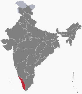
Kerala is situated between the Arabian Sea to the west and the Western Ghats to the east. Kerala's coast runs some 580 km in length, while the state itself varies between 35–120 km in width. Geologically, pre-Cambrian and Pleistocene formations comprise the bulk of Kerala's terrain. The topography consists of a hot and wet coastal plain gradually rising in elevation to the high hills and mountains of the Western Ghats. Kerala lies between northern latitude of 8°.17'.30" N and 12°. 47'.40" N and east longitudes 74°.27'.47" E and 77°.37'.12" E. Kerala's climate is mainly wet and maritime tropical, heavily influenced by the seasonal heavy rains brought up by the monsoon.

Corinda is a suburb in the City of Brisbane, Queensland, Australia. In the 2016 census, Corinda had a population of 5,064 people.

Sherwood is a suburb in the City of Brisbane, Queensland, Australia. In the 2016 census, Sherwood had a population of 5,313 people.
There have been known various classifications of landslides. Broad definitions include forms of mass movement that narrower definitions exclude. For example, the McGraw-Hill Encyclopedia of Science and Technology distinguishes the following types of landslides:

The 1893 Brisbane flood, occasionally referred to as the Great Flood of 1893 or the Black February flood, occurred in 1893 in Brisbane, Queensland, Australia. The Brisbane River burst its banks on three occasions in February 1893. It was the occurrence of three major floods in the same month that saw the period named "Black February". There was also a fourth flood event later in the same year in June. The river runs through the centre of Brisbane with much of the population living in areas beside the river. It was flooded in the first flood on 6 February due to a deluge associated with a tropical cyclone, called "Buninyong".

On 8 August 1979, a major landslip occurred in the Dunedin, New Zealand suburb of Abbotsford. It was the largest landslide in a built-up area in New Zealand's history, resulting in the destruction of 69 houses – around one sixth of the suburb – but no fatalities.

The 1973–74 Australian region cyclone season was the third most active tropical cyclone season in the Australian Region.

The 2012 Great Britain and Ireland floods were a series of weather events that affected parts of Great Britain and Ireland periodically during the course of 2012 and on through the winter into 2013. The beginning of 2012 saw much of the United Kingdom experiencing droughts and a heat wave in March. A series of low pressure systems steered by the jet stream brought the wettest April in 100 years, and flooding across Britain and Ireland. Continuing through May and leading to the wettest beginning to June in 150 years, with flooding and extreme events occurring periodically throughout Britain and parts of Atlantic Europe.

Australian east coast lows are extratropical cyclones. The most intense of these systems have many of the characteristics of subtropical cyclones. They develop between 25˚ south and 40˚ south and within 5˚ of the Australian coastline, typically during the winter months, but may occur in autumn and spring as well. Each year there are about ten "significant impact" maritime lows.

The Shire of Sherwood is a former local government area of Queensland, Australia, located in south-western Brisbane in and around the suburb of Sherwood.
The June 2008 Hong Kong Rainstorm was a rainstorm in Hong Kong on 7 June 2008 that caused flooding and landslides. It resulted in 2 deaths and 16 injuries. The Hong Kong Observatory recorded 145.5mm of precipitation at its headquarters between 08:00 to 09:00, setting the highest one-hour precipitation record. A total of 307.1mm of precipitation was recorded during that day.

Severe Tropical Cyclone Tessi was a small but potent tropical cyclone that caused extensive damage along the coast of North Queensland in early April 2000. The ninth cyclone and fourth severe tropical cyclone of the 1999–2000 Australian region cyclone season, Tessi developed on 1 April from a persistent trough of low pressure in the Coral Sea and slowly tracked west-southwestward. Tessi was an unusually compact storm that strengthened rapidly just before landfall, peaking as a Category 3 severe tropical cyclone on the Australian tropical cyclone intensity scale with 10-minute average maximum winds of 140 km/h. Around 22:00 UTC on 2 April, Tessi moved ashore about 75 km northwest of Townsville and rapidly diminished as it progressed inland. At the height of the storm, Magnetic Island experienced sustained winds of 109 km/h (68 mph), while gusts as high as 130 km/h (81 mph) were recorded in Townsville.
During the heavy rainfall over the monsoon period from 1 June to 18 August 2020, all 14 districts in Kerala were affected with 104 dead and 40 injured. Five districts in Kerala were flooded on 7 August 2020. Major reported incidents in relation to flooding include a landslide in Idukki district on 6 August, claiming 66 lives and an Air India plane crash that caused the death of 21 people. The 2020 flood in Kerala marked the third year in a row of severe monsoon flooding.

The 2022 Eastern Australia floods is an ongoing flood disaster occurring in South East Queensland, Wide Bay–Burnett and parts of coastal New South Wales. The city of Brisbane suffered major flooding, along with the cities of Maryborough, Gympie, the Sunshine Coast, Caboolture, Toowoomba, Ipswich, Logan City, the Gold Coast, Murwillumbah, Grafton, Lismore, the Central Coast and some parts of Sydney.
References
- 1 2 3 Hayne, M.; Michael-Leiba, M.; Gordon, D.; Lacey, R.; and Granger, K. (2000) Chapter 7: Landslide Risks. In: K. Granger and M. Hayne (eds.) Natural Hazards and the Risks They Pose to South-East Queensland. Canberra: AGSO and Bureau of Meteorology.
- 1 2 3 Geoscience Australia, cited in Holt, J.; Westerman, S. (2005), Redland Landslide Hazard Assessment. Report #33529 for Redland Shire Council, Brisbane: SMEC Australia, p. 35 (Attachment)
- 1 2 3 'Landslips Force Evacuation in Brisbane: Hundreds of Homes, High School in Danger'. Sydney Morning Herald. 21 March 1974; at p. 13.
- 1 2 Granger, K. and Hayne, M., (2000) 'Introduction', in K. Granger and M. Hayne. (eds.) Natural Hazards and the Risks They Pose to South-East Queensland. Canberra: AGSO and Bureau of Meteorology, at p. 16.
- ↑ Brisbane City Council (2011) Flood Flag Map: http://www.brisbane.qld.gov.au/community/community-safety/disasters-and-emergencies/types-of-disasters/flooding/understanding-your-flood-risk/flood-flag-map/index.htm Archived 19 April 2012 at the Wayback Machine , accessed 19/4/12.
- ↑ CSIRO (2012) State of the Climate 2012: http://www.csiro.au/Outcomes/Climate/Understanding/~/media/8E59FBA4F8A94FE4B84F01E271226316.pdf, accessed 20/4/12.
Coordinates: 27°32′55″S152°58′31″E / 27.54854°S 152.97535°E