Taree is a city on the Mid North Coast, New South Wales, Australia. It and nearby Cundletown were settled in 1831 by William Wynter. Since then it has grown to a population of 26,381, and commands a significant agricultural district. Situated on a floodplain by the Manning River, it is 16 km from the Tasman Sea coast, and 317 km north of Sydney.

Forbes is a town in the Central West region of New South Wales, Australia, located on the Newell Highway between Parkes and West Wyalong. According to the 2021 census, Forbes has a population of 9, 319. Forbes is probably named after Sir Francis Forbes, first Chief Justice of NSW.

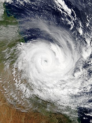
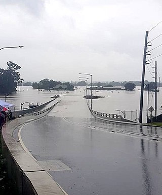
Severe storms in Australia refers to the storms, including cyclones, which have caused severe damage in Australia.
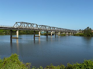
Coopernook is a small town in mid-north New South Wales, Australia. It is located 24 kilometres north of Taree and 11 kilometres west of Harrington and is administered by Mid-Coast Council. At the 2021 census, Coopernook and the surrounding area had a population of 625 people, while the town itself had 430 inhabitants. It was formerly situated on the Pacific Highway, until 22 March 2006, when the Coopernook Bypass was opened. The old highway crossed the Lansdowne River on a narrow iron girder bridge.
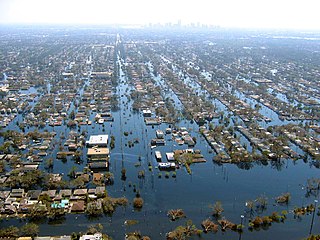
Floods in the United States (2000–present) is a list of flood events which were of significant impact to the country during the 21st century, since 2000. Floods are generally caused by excessive rainfall, excessive snowmelt, storm surge from hurricanes, and dam failure.

Australia has had over 160,708 floods in the last 10 years, many of which have taken out homes, wildlife and many habitats.
The 2010 Victorian floods were a widespread series of flood events across the state of Victoria, Australia. The floods, which followed heavy rain across southeastern Australia in early September 2010, caused the inundation of about 250 homes, hundreds of evacuations and millions of dollars of damage. Weather warnings were initially issued for Victoria on Thursday 2 September and rain began to fall on the Friday, continuing through the weekend to Tuesday. Heavy rain fell in most regions of the state, particularly at higher altitudes in the state's west and northeast, flooding the upper reaches of many of Victoria's major rivers. A state of emergency was declared with State Emergency Service crews arriving from Queensland, South Australia and Tasmania. The floods proceeded an extensive drought period that had effected the entirety of Australia.

A series of floods hit Queensland, Australia, beginning in December 2010. The floods forced the evacuation of thousands of people from towns and cities. At least 90 towns and over 200,000 people were affected. Damage initially was estimated at A$1 billion before it was raised to $2.38 billion. The estimated reduction in Australia's GDP is about A$30 billion. As of March 2012, there were 33 deaths attributed to the floods, with a further three people still missing.
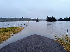
Australian rivers have been subject to devastating floods in New South Wales, recorded since colonisation. Flooding in New South Wales has predominately been caused by excessive flows into rivers located in New South Wales and, to a lesser extent, excessive flows into rivers located in Queensland and Victoria. Floods can devastate local communities and impact the entire local economy.

The 2010 Gascoyne River flood was regarded as the most severe flood to take place along the Gascoyne River in Western Australia on record. Triggered by record-breaking rainfall, amounting to over 6,000 percent of the monthly mean, 313.6 mm (12.35 in) and 5 mm (0.20 in) respectively, in just four days, the floods caused widespread damage in the region. By 17 December, the river began to rise in response to the heavy rains, eventually exceeding its banks within two days. Water levels reached record values at three stations along the river, cresting at 15.53 m (51.0 ft) near Fishy Pool. Evacuation orders were issued for several towns affected by rising waters. The most substantial impact was felt in Carnarvon where entire homes were washed away. Following the disaster, emergency supplies and funds were distributed to affected residents to aid them in restoring their livelihoods. Though no people died in the event, an estimated two thousand head of cattle perished and damage was estimated at A$100 million.

Tropical Cyclone Oswald was a tropical cyclone that passed over parts of Queensland and New South Wales, Australia over a number of days, causing widespread impact including severe storms, flooding, and water spouts. Coastal regions of Queensland were the most impacted with Mundubbera, Eidsvold, Gayndah and Bundaberg in the Wide Bay–Burnett hit severely. In many places the rainfall total for January set new records. Across the affected region, damage from severe weather and flooding amounted to at least A$2.4 billion.

Australian east coast lows are extratropical cyclones or low-pressure systems on the coast of southeastern Australia that may be caused by both mid-latitude and tropical influences over a variety of levels in the atmosphere. These storms should not be confused with Australian region tropical cyclones which typically affect the northern half of the continent.
Severe Tropical Cyclone Debbie in 2017 was the strongest tropical cyclone to strike Queensland since Marcia in 2015, and was the costliest tropical cyclone in Australia since Yasi in 2011. Forming as a tropical low on 23 March, the low gradually intensified into a named tropical cyclone on 25 March. After steadily strengthening offshore to a Category 4 system, Debbie eventually made landfall near Airlie Beach, at 12:40 AEST on 28 March. Afterwards, Debbie rapidly weakened into a tropical low by late 28 March, but continued to travel south, causing significant damage and flooding in the populous areas of South East Queensland and Northern Rivers. In total, the storm caused A$3.5 billion (US$2.67 billion) in damage and fourteen deaths across Australia, primarily as a result of extreme flooding. This makes Debbie the deadliest cyclone to hit Australia since Fifi in 1991.

A black nor'easter is a persistent and potentially violent north-easterly storm that occurs on the east coast of Australia, particularly from southeastern Queensland to southern New South Wales, usually between late spring and early autumn, about two days a year.

Severe weather events or extreme weather events in Sydney, Australia, include hailstorms, thunderstorms, gale, bushfires, heatwaves, drought, and flash flooding. Sydney is rarely affected by cyclones, although remnants of cyclones do affect the city.
Extreme rainfall on the east coast of Australia beginning on 18 March 2021 led to widespread flooding in New South Wales, affecting regions from the North Coast to the Sydney metropolitan area in the south. Suburbs of Sydney experienced the worst flooding in 60 years, and the events were described by NSW Premier Gladys Berejiklian as "one in 100-year" flooding. Far-southeast communities in Queensland were also affected by flooding and heavy rainfall, though to a lesser extent than those in New South Wales.

The 2022 eastern Australia floods were one of the nation's worst recorded flood disasters with a series of floods that occurred from late February to early May in South East Queensland, the Wide Bay–Burnett and parts of coastal New South Wales. Brisbane suffered major flooding, along with the cities of Maryborough, Gympie, the Sunshine Coast, Caboolture, Toowoomba, Gatton, Ipswich, Logan City, the Gold Coast, Murwillumbah, Mullumbimby, Grafton, Byron Bay, Ballina, Lismore, the Central Coast and parts of Sydney.

Beginning on July 24, 2022, and lasting for a week, many flash flooding events hit several areas of the United States. These areas included parts of Missouri and Illinois, especially Greater St. Louis, Eastern Kentucky, Southwest Virginia, parts of West Virginia, and the Las Vegas Valley. Several rounds of severe thunderstorms began in Missouri on July 24, culminating during July 25 and 26, when St. Louis broke its previous 1915 record for the most rainfall in a span of 24 hours. Governor Mike Parson declared a state of emergency on July 26. Over one hundred people were rescued from floods, and two people were killed. Late on July 27 and into July 28, historic flooding began in central Appalachia, particularly in Kentucky, where a state of emergency was declared. A total of 38 people were killed in Kentucky as a direct result of flooding, with a 39th fatality occurring days later during cleanup efforts and a 40th coming in September during cleanup efforts in Pike County.
The 2022 south eastern Australia floods are a series of floods that have occurred in south-eastern Australia since October 2022. Some towns experienced the highest river peaks in decades, and many places saw rivers peak multiple times. The floods were attributed to excess torrential rain caused by La Niña and a negative Indian Ocean Dipole.
2022 was an extremely wet year for Australia, coming out of a back-to-back La Niña in the summer of 2021-22, a Negative Indian Ocean Dipole developing over the winter and a third back-to-back La Niña in the spring of 2022.