Related Research Articles

Hurricane Dennis caused flooding in North Carolina and the Mid-Atlantic states in early September 1999, which would later be compounded by Hurricane Floyd. The fifth tropical cyclone of the season, Dennis developed from a tropical wave to the north of Puerto Rico on August 24. Originally a tropical depression, the system moved west-northwestward and strengthened into a tropical storm despite unfavorable wind shear. The storm became a hurricane by August 26. After striking the Abaco Islands, conditions improved, allowing for Dennis to strengthen into a Category 2 on the Saffir–Simpson scale by August 28. Around this time, Dennis began to move parallel to the Southeastern United States. Early on August 30, the storm peaked with winds of 105 mph (165 km/h). By the following day, steering currents collapsed and the storm interacted with a cold front, causing Dennis to move erratically offshore North Carolina. Wind shear and cold air associated with the front weakened Dennis to a tropical storm on September 1 and removed some of its tropical characteristics. Eventually, warmer ocean temperatures caused some re-strengthening. By September 4, Dennis turned northwestward and made landfall in Cape Lookout, North Carolina, as a strong tropical storm. The storm slowly weakened inland, before transitioning into an extratropical cyclone over western New York on September 7.
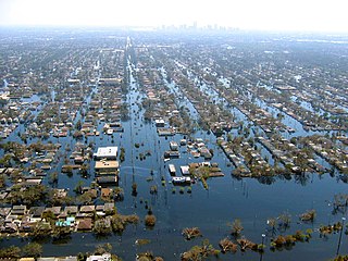
Floods in the United States (2000–present) is a list of flood events which were of significant impact to the country during the 21st century, since 2000. Floods are generally caused by excessive rainfall, excessive snowmelt, storm surge from hurricanes, and dam failure.

A series of large floods occurred in parts of the United Kingdom during the summer of 2007. The worst of the flooding occurred across parts of Northern Ireland and Scotland on 14 June; East Yorkshire and the Midlands on 15 June; Yorkshire, the Midlands, Gloucestershire, Herefordshire and Worcestershire on 25 June; and Gloucestershire, Herefordshire, Worcestershire, Oxfordshire, Berkshire and South Wales on 28 July 2007.
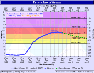
The 2008 Tanana Valley flood or the 2008 Fairbanks flood was a flood in late July and early August 2008 that affected several rivers in the central portion of the American state of Alaska. The city of Fairbanks, Alaska saw high water levels, while the towns of Nenana, Salcha, and Old Minto received heavy damage. The Salcha River and Tanana River reached their second-highest levels since record-keeping began, while the Chena River, which bisects Fairbanks, was kept below flood stage by the use of the Chena River Lakes Flood Control Project.
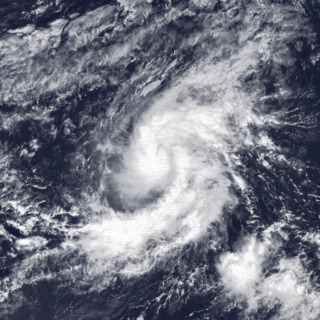
Tropical Storm Octave was considered the worst tropical cyclone in the history of Arizona. The nineteenth tropical cyclone and fifteenth named storm of the 1983 Pacific hurricane season, the origins of Tropical Storm Octave were from a tropical disturbance that formed south of the Gulf of Tehuantepec on September 23, 1983. Steered by a deep layer high over Mexico, the disturbance moved west for four days before becoming a tropical depression on September 27 off the southwest coast of Mexico. Over an area of warm sea surface temperatures, it was able to quickly strengthen to peak winds of 50 mph (85 km/h), through wind shear prevented much further development. By September 30, Octave was accelerating to the northeast, steadily weakening due to cooler waters. That day it weakened to tropical depression status, and on October 2, Octave dissipated.
The 2010 Victorian floods were a widespread series of flood events across the state of Victoria, Australia. The floods, which followed heavy rain across southeastern Australia in early September 2010, caused the inundation of about 250 homes, hundreds of evacuations and millions of dollars of damage. Weather warnings were initially issued for Victoria on Thursday 2 September and rain began to fall on the Friday, continuing through the weekend to Tuesday. Heavy rain fell in most regions of the state, particularly at higher altitudes in the state's west and northeast, flooding the upper reaches of many of Victoria's major rivers. A state of emergency was declared with State Emergency Service crews arriving from Queensland, South Australia and Tasmania. The floods proceeded an extensive drought period that had effected the entirety of Australia.

Tropical Cyclone Oswald was a tropical cyclone that passed over parts of Queensland and New South Wales, Australia over a number of days, causing widespread impact including severe storms, flooding, and water spouts. Coastal regions of Queensland were the most impacted with Mundubbera, Eidsvold, Gayndah and Bundaberg in the Wide Bay–Burnett hit severely. In many places the rainfall total for January set new records. Across the affected region, damage from severe weather and flooding amounted to at least A$2.4 billion.

Australian east coast lows are extratropical cyclones or low-pressure systems on the coast of southeastern Australia that may be caused by both mid-latitude and tropical influences over a variety of levels in the atmosphere. These storms should not be confused with Australian region tropical cyclones which typically affect the northern half of the continent.
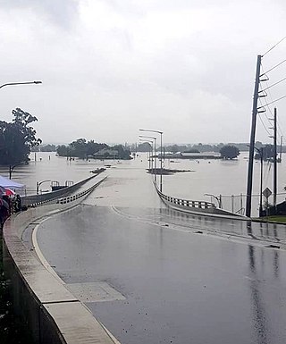
Extreme rainfall on the east coast of Australia beginning on 18 March 2021 led to widespread flooding in New South Wales, affecting regions from the North Coast to the Sydney metropolitan area in the south. Suburbs of Sydney experienced the worst flooding in 60 years, and the events were described by NSW Premier Gladys Berejiklian as "one in 100-year" flooding. Far-southeast communities in Queensland were also affected by flooding and heavy rainfall, though to a lesser extent than those in New South Wales.
The 2021 central New Zealand floods were the result of a torrential rainstorm that affected central New Zealand between 17 and 18 July 2021. This storm led to flooding in the West Coast's Buller District, the Tasman District, and the Marlborough Region in the South Island, prompting the evacuations of residents and the declaration of a state of emergency. Flooding also impacted the Wellington region.

The 2022 eastern Australia floods were one of the nation's worst recorded flood disasters with a series of floods that occurred from late February to early May in South East Queensland, the Wide Bay–Burnett and parts of coastal New South Wales. Brisbane suffered major flooding, along with the cities of Maryborough, Gympie, the Sunshine Coast, Caboolture, Toowoomba, Gatton, Ipswich, Logan City, the Gold Coast, Murwillumbah, Mullumbimby, Grafton, Byron Bay, Ballina, Lismore, the Central Coast and parts of Sydney.

Severe Tropical Cyclone Dovi was a powerful tropical cyclone across the Southern Pacific in February 2022. The system became the third named tropical cyclone of the 2021–22 South Pacific cyclone season. The storm first formed in the Australian basin on February 4 before crossing over into the South Pacific. The storm caused one death in New Caledonia, and several mudslides occurred in New Caledonia and Vanuatu. Dovi also caused flight cancellations and damage out of New Zealand.

Beginning on July 24, 2022, and lasting for a week, many flash flooding events hit several areas of the United States. These areas included parts of Missouri and Illinois, especially Greater St. Louis, Eastern Kentucky, Southwest Virginia, parts of West Virginia, and the Las Vegas Valley. Several rounds of severe thunderstorms began in Missouri on July 24, culminating during July 25 and 26, when St. Louis broke its previous 1915 record for the most rainfall in a span of 24 hours. Governor Mike Parson declared a state of emergency on July 26. Over one hundred people were rescued from floods, and two people were killed. Late on July 27 and into July 28, historic flooding began in central Appalachia, particularly in Kentucky, where a state of emergency was declared. A total of 38 people were killed in Kentucky as a direct result of flooding, with a 39th fatality occurring days later during cleanup efforts and a 40th coming in September during cleanup efforts in Pike County.
The 2022 south eastern Australia floods are a series of floods that have occurred in south-eastern Australia since October 2022. Some towns experienced the highest river peaks in decades, and many places saw rivers peak multiple times. The floods were attributed to excess torrential rain caused by La Niña and a negative Indian Ocean Dipole.

Beginning on Friday, 27 January 2023, regions across the upper North Island of New Zealand experienced widespread catastrophic floods caused by heavy rainfall, with Auckland being the most significantly affected as the Auckland Anniversary holiday weekend began.
On 3 June 2015, a low weather system brought heavy rain to the coastal Otago Region particularly South Dunedin. South Dunedin experienced heavy flooding, which was exacerbated by the area's high water table and the breakdown of the Portobello pumping station. 1,200 homes and businesses were damaged by flood damage. The Dunedin City Council (DCC) described the 3 June 2015 flood event as a "one in a 100 year" flood, with about 175mm of rain falling during a 24-hour period. The DCC subsequently drew criticism for the poor state of the city's storm water infrastructure.
In late June 2024, torrential rain led to flooding in the North Island's East Coast regions of Hawke's Bay and the Gisborne District. This flooding led to evacuations and local states of emergency being declared in Hastings and Wairoa. 400 properties were flooded in Wairoa. In response, Emergency Management and Recovery Minister Mark Mitchell announced that the New Zealand Government would contribute $300,000 to mayoral relief funds in Hastings, Wairoa and the Gisborne District. According to Mayor of Wairoa Craig Little, Wairoa sustained a loss of NZ$40 million.

In early October 2024, the Otago region of New Zealand's South Island experienced heavy rainfall and significant flooding and landslides. The weather event affected coastal areas in Otago including North Otago, Dunedin, and the Clutha District, which received an estimated two-months worth of rainfall between 2 and 4 October. On 3 October, a state of emergency was declared in Dunedin, with residents in some low-lying suburbs being told to evacuate. By 4 October, the Clutha District had also declared a state of emergency. By 6 October, the state of emergency in Dunedin and Clutha had been lifted due to improving weather conditions and floodwaters subsiding.

In late January 1984, the Southland and Fiordland regions of New Zealand's South Island experienced a strong north-westerly front and moist conditions, which led to heavy rainfall and flooding between 26 and 27 January. Several urban centres and towns in Southland including Invercargill, Riverton, Bluff, Otautau and Tuatapere experienced significant flooding. In response, the Mayor of Invercargill Eve Poole and Civil Defence authorities declared local states of emergency in Invercargill and much of Southland. The 1984 Southland floods caused significant damage to local housing, farms, infrastructure, and property, with insurance claims amounting to between $45.8 million and $55 million.
References
- 1 2 3 4 5 6 Corlett, Eva (19 August 2022). "New Zealand floods could take years to clean up, with 1,200 people displaced". The Guardian. ISSN 0261-3077 . Retrieved 31 August 2023.
- 1 2 3 4 5 6 7 "New Zealand floods: hundreds evacuate as 'atmospheric river' brings deluge". The Guardian. 18 August 2022. ISSN 0261-3077 . Retrieved 31 August 2023.
- ↑ "Cost of natural disasters". ICNZ | Insurance Council of New Zealand. Retrieved 1 September 2023.
- 1 2 3 4 "100 evacuations in Nelson overnight as heavy rain continues". 1 News. Retrieved 1 September 2023.
- 1 2 "'Unbelievable' wild weather – more homes evacuated overnight". NZ Herald. 1 September 2023. Retrieved 1 September 2023.
- ↑ "Weather-related claims in August hit $48m – Insurance Council". RNZ . 12 October 2022. Retrieved 1 September 2023.
- ↑ "Nelson floods: Government agrees to buyout deal with council". RNZ . 1 September 2023. Retrieved 31 August 2023.