
The Brisbane River is the longest river in South-East Queensland, Australia, and flows through the city of Brisbane, before emptying into Moreton Bay on the Coral Sea. John Oxley, the first European to explore the river, named it after the Governor of New South Wales, Sir Thomas Brisbane in 1823. The penal colony of Moreton Bay later adopted the same name, eventually becoming the present city of Brisbane. The river is a tidal estuary and the water is brackish from its mouth through the majority of the Brisbane metropolitan area westward to the Mount Crosby Weir. The river is wide and navigable throughout the Brisbane metropolitan area.

The Logan River is a perennial river located in the Scenic Rim, Logan and Gold Coast local government areas of the South East region of Queensland, Australia. The 184-kilometre (114 mi)-long river is one of the dominant waterways in South East Queensland that drains the southern ranges of the Scenic Rim and empties into Moreton Bay after navigating the City of Logan, a major suburban centre located south of Brisbane. The catchment is dominated by urban and agricultural land use. Near the river mouth are mangrove forests and a number of aquaculture farms.

Bulimba Creek, originally known as Doboy Creek or Doughboy Creek, ia a perennial stream that is a tributary of the Brisbane River, located in suburban Brisbane in the South East region of Queensland, Australia.

The Taylor Range or Herbert Taylor Range is a mountain range on the western edge of Brisbane, Queensland, Australia. It was first named The Glenmorrison Range by John Oxley during his exploration of the area in January 1824. In 1828, the colonial botanist Charles Fraser, whilst looking at the range from the Ipswich area, noted the bearings as Sir Herbert Taylor’s Range from which the current name derived.

The Bremer River is a river that is a tributary of the Brisbane River, located in the Scenic Rim and Brisbane regions of South East Queensland, Australia. The 100-kilometre (62 mi)-long Bremer River drains several Scenic Rim valleys in south-east Queensland, including the Fassifern Valley, with its catchment area covering approximately 2,032 square kilometres (785 sq mi). Most valleys within the catchment have extensive river terraces. The Bremer River system is extremely degraded.

Brisbane Forest Park, is located on parts of the D'Aguilar Range. The large nature reserve lies on the western boundary of City of Brisbane into the Moreton Bay Region, Queensland, Australia, in Enoggera Reservoir, adjacent to The Gap and between the Mount Coot-tha Reserve on the Taylor Range and higher peaks to the north. Brisbane Forest Park supports plants and animals and is essential to their survival. The main entrance is located in the suburb of The Gap although there are a number of other access points.

The Oxley Creek is a creek that is a tributary of the Brisbane River, located in suburban Brisbane in the South East region of Queensland, Australia.

The Lockyer Creek is a creek located in South East Queensland, Australia. A tributary of the Brisbane River, the creek is a major drainage system in the Lockyer Valley. Rising on the eastern slopes of the Great Dividing Range, the creek flows generally north-easterly for more than 100 kilometres (62 mi) before it reaches its confluence with the Brisbane River north-northeast of Lowood, and downstream from the Wivenhoe Dam. The creek is named after Edmund Lockyer.

Paddington is an inner suburb in the City of Brisbane, Queensland, Australia. In the 2016 census, Paddington had a population of 8,562 people.

Enoggera is a suburb of the City of Brisbane, in Queensland, Australia.

St Johns Wood is a neighbourhood within the suburb of Ashgrove in the City of Brisbane, Queensland, Australia.
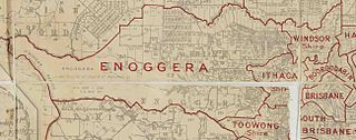
The Town of Ithaca is a former local government area of Queensland, Australia, located in inner western Brisbane.

The Enoggera Dam is a heritage-listed dam, which is located within the outer, western suburb of Enoggera Reservoir, in Brisbane, Queensland, Australia.

The Gold Creek Dam is an earth-fill embankment dam with an un-gated spillway across the Gold Creek that is located in the South East region of Queensland, Australia. The main purpose of the dam is for potable water supply of the Brisbane region. The resultant reservoir is called the Gold Creek Reservoir.

Moggill Creek is a creek in Brisbane, the largest city in Queensland, Australia. The creek rises on the Taylor Range and runs in a south-easterly direction from the southern edge of Brisbane Forest Park in Kholo and Pullenvale, flowing through Upper Brookfield, Brookfield and joining the Brisbane River at Kenmore. Before entering the Brisbane River the creek is crossed by Moggill Road and winds through Rafting Ground Reserve.

Norman Creek is a small tributary of the Brisbane River. The headwaters of the creek are located on the northern slopes of Toohey Mountain and Mount Gravatt in southern Brisbane. The name derives from a corruption of Gorman's Creek, after Lieutenant Gorman, of H. M. 8th Foot - the last commandant at Moreton Bay.

Robert Whyte is an Australian writer. He was a founding co-owner and director of the Brisbane-based multimedia firm ToadShow. After 2012 he participated in the Australian Government's new species exploration program Bush Blitz. His works include The Creek in Our Back Yard: a practical guide to creek restoration (2011) and A Field Guide to Spiders of Australia for CSIRO Publishing 2017.

Enoggera Creek is a creek which flows through the City of Brisbane in South-East Queensland, Australia.
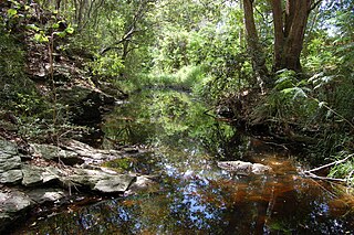
Ithaca Creek is a waterway in the Enoggera Creek catchment, in the western suburbs of Brisbane, Queensland, Australia. It arises in the Taylor Range at the Mount Coot-tha forest with two streams, one arising at J C Slaughter Falls, the other and stronger source being Simpson Falls, the western branch.

Ithaca War Memorial and Park is a heritage-listed memorial and park at Enoggera Terrace, Paddington, Queensland, Australia. The memorial was designed and built by Arthur Henry Thurlow between 1921 and 1925. The park was built and designed by Alexander Jolly. It is also known as Alexander Jolly Park. It was added to the Queensland Heritage Register on 21 October 1992.
