
Captain George Vancouver was a British Royal Navy officer best known for his 1791–1795 expedition, which explored and charted North America's northwestern Pacific Coast regions, including the coasts of what are now the Canadian province of British Columbia as well as the US states of Alaska, Washington, Oregon, and California. The expedition also explored the Hawaiian Islands and the southwest coast of Australia.

The maritime European exploration of Australia consisted of several waves of European seafarers who sailed the edges of the Australian continent. Dutch navigators were the first Europeans known to have explored and mapped the Australian coastline. The first documented encounter was that of Dutch navigator Willem Janszoon, in 1606. Dutch seafarers also visited the west and north coasts of the continent, as did French explorers.

Bass Strait is a strait separating the island state of Tasmania from the Australian mainland. The strait provides the most direct waterway between the Great Australian Bight and the Tasman Sea, and is also the only maritime route into the economically prominent Port Phillip Bay.

Admiral of the Fleet Richard Howe, 1st Earl Howe,, was a British naval officer. After serving throughout the War of the Austrian Succession, he gained a reputation for his role in amphibious operations against the French coast as part of Britain's policy of naval descents during the Seven Years' War. He also took part, as a naval captain, in the decisive British naval victory at the Battle of Quiberon Bay in November 1759.

George Bass was a British naval surgeon and explorer of Australia.
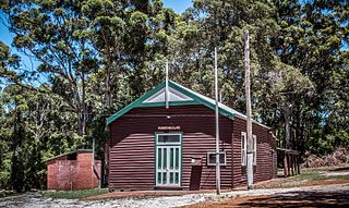
Torbay is a small town and a bay in the Great Southern region of Western Australia, 20 kilometres (12 mi) west of Albany. Torbay is within the City of Albany local government area. The Torbay townsite was gazetted in 1910.

King George Sound is a sound on the south coast of Western Australia. Named King George the Third's Sound in 1791, it was referred to as King George's Sound from 1805. The name "King George Sound" gradually came into use from about 1934, prompted by new Admiralty charts supporting the intention to eliminate the possessive 's' from geographical names.

Cape Leeuwin is the most south-westerly mainland point of the Australian continent, in the state of Western Australia.

Augusta is a town on the south-west coast of Western Australia, where the Blackwood River flows into Flinders Bay. It is the nearest town to Cape Leeuwin, on the furthest southwest corner of the Australian continent. In the 2001 census it had a population of 1,091; by 2016 the population of the town was 1,109.

His Majesty's Armed Survey Vessel Lady Nelson was commissioned in 1799 to survey the coast of Australia. At the time large parts of the Australian coast were unmapped and Britain had claimed only part of the continent. The British Government were concerned that, in the event of settlers of another European power becoming established in Australia, any future conflict in Europe would lead to a widening of the conflict into the southern hemisphere to the detriment of the trade that Britain sought to develop. It was against this background that Lady Nelson was chosen to survey and establish sovereignty over strategic parts of the continent.
St Alouarn Islands are a group of islands and rocks south-east of Cape Leeuwin in Western Australia, approximately 11 km south of Augusta in Flinders Bay.
Point Hicks, is a coastal headland in the East Gippsland region of Victoria, Australia, located within the Croajingolong National Park. The point is marked by the Point Hicks Lighthouse that faces the Tasman Sea.

Captain Matthew Flinders was a British navigator and cartographer who led the first inshore circumnavigation of mainland Australia, then called New Holland. He is also credited as being the first person to utilise the name Australia to describe the entirety of that continent including Van Diemen's Land, a title he regarded as being "more agreeable to the ear" than previous names such as Terra Australis.
The Baudin expedition of 1800 to 1803 was a French expedition to map the coast of New Holland. Nicolas Baudin was selected as leader in October 1800. The expedition started with two ships, Géographe, captained by Baudin, and Naturaliste captained by Jacques Hamelin, and was accompanied by nine zoologists and botanists, including Jean-Baptiste Leschenault de la Tour, François Péron and Charles-Alexandre Lesueur as well as the geographer Pierre Faure.

Tryal Rocks, sometimes spelled Trial Rocks or Tryall Rocks, formerly known as Ritchie's Reef or Greyhound's Shoal, is a reef of rock located in the Indian Ocean off the northwest coast of Australia, 14 kilometres (8.7 mi) northwest of the outer edge of the Montebello Islands group. It is named for the Tryall, the first known shipwreck in Australian waters, which sank after striking the then-uncharted rocks in 1622. Described as "the theme and dread of every voyager to the eastern islands", their location was sought for over three centuries before finally being determined in 1969.

Cape Spencer is a headland in the Australian state of South Australia located on the south west tip of Yorke Peninsula in the gazetted locality of Inneston. It was named after George Spencer, 2nd Earl Spencer by Matthew Flinders during March 1802. It has been the site of an operating navigation aid since 1950 and has been located within the Innes National Park since 1970.

The Backstairs Passage is a strait in South Australia lying between Fleurieu Peninsula on the Australian mainland and Dudley Peninsula on the eastern end of Kangaroo Island. The western edge of the passage is a line from Cape Jervis on Fleurieu Peninsula to Kangaroo Head on Kangaroo Island. The Pages, a group of islets, lie in the eastern entrance to the strait. About 14 km wide at its narrowest, it was formed by the rising sea around 13,000 years ago, at the end of the Pleistocene era, when it submerged the land connecting what is now Kangaroo Island with the Fleurieu Peninsula. Backstairs Passage was named by Matthew Flinders whilst he and his crew on HMS Investigator were exploring and mapping the coastline of South Australia in 1802.

HMS Investigator was the mercantile Fram, launched in 1795, which the Royal Navy purchased in 1798 and renamed HMS Xenophon, and then in 1801 converted to a survey ship under the name HMS Investigator. In 1802, under the command of Matthew Flinders, she was the first ship to circumnavigate Australia. The Navy sold her in 1810 and she returned to mercantile service under the name Xenophon. She was probably broken up c.1872.
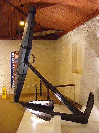
The HMS Investigator Anchors are the two anchors that jettisoned from HMS Investigator on the morning of Saturday, 21 May 1803, by her commander, Matthew Flinders, in order to avoid running aground on Middle Island in the Archipelago of the Recherche on the south coast of New Holland. In 1973, the anchors were located and recovered by members of the Underwater Explorers Club of South Australia (UEC). The recovered anchors became the subject of an ownership dispute between various governments, particularly those of South Australia and Western Australia due to their historic significance as artefacts of a major voyage of European exploration. The dispute was resolved with the ownership of the anchors going to the Australian Government who subsequently gifted one of the anchors to the South Australian Government. The pair of artefacts is also known as Flinders' Anchors.
Cape Wiles is a headland located on the west side of the southern tip of Eyre Peninsula in South Australia about 27 kilometres south west of the city of Port Lincoln. The cape is described by one source as being the south east extremity of “a broad promontory” of which Cape Carnot is the south west extremity at a distance of 3 nautical miles to the west. The cape also is the western extremity of Sleaford Bay.
